焼額山Yakebitaiyama

雪場資訊Resort info

燒額山以針葉林間長線與便於反覆滑行的纜車配置見長,官方亦介紹粉雪區及不同程度路線,適合重視完整轉彎節奏的旅客。少量近期顧客評價具體稱讚整理品質、可由高處一氣滑下的多條路線與景色,支持其巡航練習優勢。它同時是志賀高原的一部分,不能把全山共通票與局部票混為一談;早場、跨區連接及春季範圍應另查。Yakebitaiyama is distinguished by long runs through conifer forest and a gondola-based layout suited to repeated top-to-bottom skiing. Official information also describes powder sectors and terrain for different abilities. A few recent customer reviews specifically praise grooming, scenery and the choice of continuous descents, supporting its appeal for focused cruising and technique work. It remains one sector of Shiga Kogen, not the whole network. Pass validity, early-morning sessions, inter-area links and the actual spring operating footprint should be checked separately.
- 縣/地區Prefecture / area
- 長野縣 · 山之內町Yamanouchi · Nagano
- 標高/落差Elevation / vertical
- 山腳 1,555 m・山頂 2,000 m・垂直 440 mBase 1,555 m · top 2,000 m · vertical 440 m來源source
- 纜車Lifts
- 5 座5來源source
- 最長滑道Longest run
- 2.4 km來源source
- 2026-27 開放日2026-27 opening
- 2026-12-042026-12-04來源source
- 地形公園Terrain park
- 有:官網設有「スノーパーク」頁面Yes: The official site has a snow park page來源source
- 票價Lift prices
大人Adult シニアSenior 兒童Child 1 日券(1日券(大人))1-day (1日券(大人)) ¥7,000 — — 2026-27 大人 1 日券,日圓。JAPANSNOWLINE 於 10/19 對照官網確認;長者與兒童票價未整理,請以官網為準。2026-27 adult 1-day ticket in yen, checked against the official site by JAPANSNOWLINE on 10/19. Senior and child prices not yet compiled; check the official site.
來源source
雪道圖Trail map
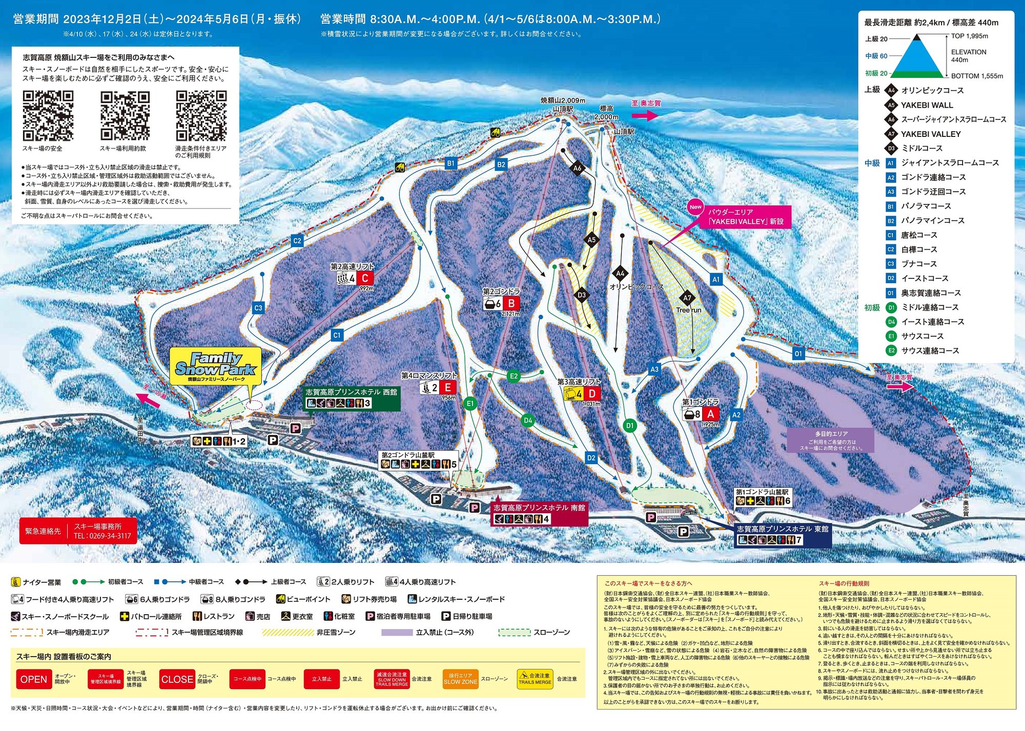 點圖看大圖Tap to enlarge
圖片來源:Snowline(snowline.jp)Image source: Snowline (snowline.jp) · 著作權屬各雪場,本站僅縮小轉載供參考。Copyright belongs to the resort; shown reduced for reference only.
3D 雪場地圖3D map
全螢幕 / 新分頁開啟Full screen / new tab拖曳旋轉、滾輪或雙指縮放。3D 地圖為非官方,地形來自 Mapterhorn,底圖為 OpenFreeMap,可切換國土地理院空拍圖,雪道與纜車來自 OpenStreetMap,收錄在「中部 3D 雪場地圖版本庫」(3DChubu-0010)。手機上有定位按鈕。Drag to rotate, scroll or pinch to zoom. Unofficial 3D map: terrain from Mapterhorn, OpenFreeMap basemap with a GSI aerial photo toggle, runs and lifts from OpenStreetMap, published in the Chubu 3D library (3DChubu-0010). On phones there is a locate button. chubu-3d.pages.dev
出典:国土地理院(加工)・© OpenStreetMap contributors(ODbL)Source: Geospatial Information Authority of Japan (processed) · © OpenStreetMap contributors (ODbL)