栂池高原Hakuba Tsugaike

雪場資訊Resort info

栂池高原以山腳極寬緩坡最具代表性,官方同時提供高處、長線與更具挑戰路線,讓親子練習和進階探索可分開安排。少量顧客評價特別肯定雪道寬度、路線多樣及新雪體驗,也有人在天晴日享受從容周轉。這不代表全區永遠少人或全部適合新手;近年官方曾公布設備安全與局部復駛資訊,出發前應看當季地圖及運行狀態。Tsugaike is especially distinctive for its exceptionally broad lower beginner terrain, while official information also covers higher slopes, long descents and stronger challenges. That separation helps families practise without making the entire mountain a beginner-only proposition. A few visitors praise the piste width, route variety and fresh snow, with another enjoying little waiting on a particular clear day. Those experiences are not universal crowd forecasts. Recent official safety and reopening notices make checking current lift operation and the latest map particularly worthwhile.
- 縣/地區Prefecture / area
- 長野縣 · 小谷村Otari · Nagano
- 標高/落差Elevation / vertical
- 山腳 800 m・山頂 1,704 m・垂直 900 mBase 800 m · top 1,704 m · vertical 900 m來源source
- 纜車Lifts
- 18 座18來源source
- 最長滑道Longest run
- 4.9 km來源source
- 2026-27 開放日2026-27 opening
- 12/1 開放(官方公布,視降雪而定)Opens 12/1 (official, snow permitting)來源source
- 地形公園Terrain park
- 有:TG Parks(榛の木高速雙人吊椅旁);另有需登記的 Tsugaike Powder DBD 區。Yes: TG Parks by the Han-no-ki pair lift; gated Tsugaike Powder DBD areas.來源source
- 票價Lift prices
大人Adult 長者Senior 兒童Child 1 日券1-day ¥9,800 ¥8,000 ¥7,000 2026-27 雪季 1 日券,日圓,取自 SnowJapan(整理自官網)。原文分級:Adult: 9,800 yen;Child (elementary): 7,000 yen;Senior (ages 60 and above): 8,000 yen。2026-27 1-day ticket in yen, from SnowJapan (compiled from the official site). Categories as listed: Adult: 9,800 yen; Child (elementary): 7,000 yen; Senior (ages 60 and above): 8,000 yen.
來源source
雪道圖Trail map
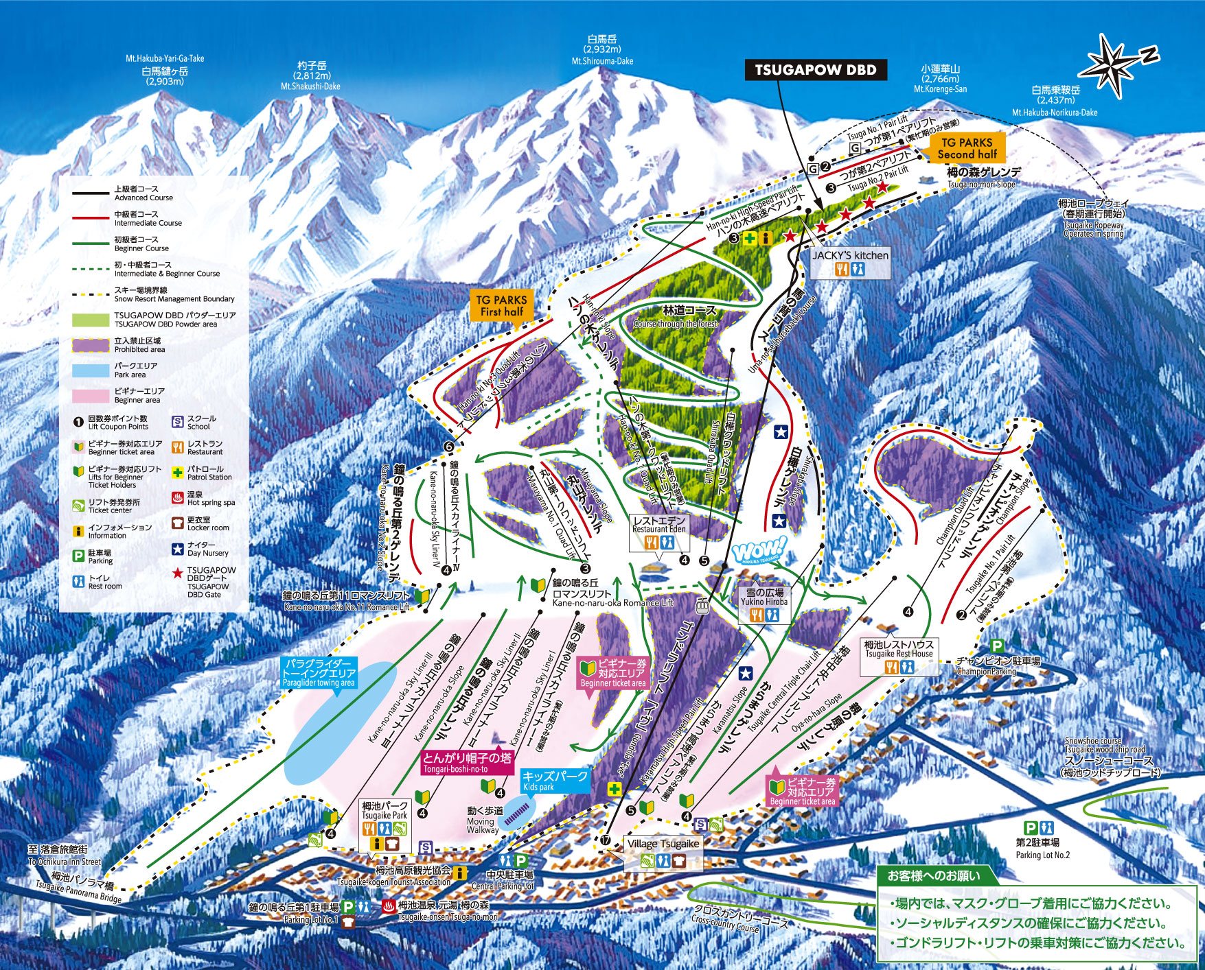 點圖看大圖Tap to enlarge
圖片來源:Snowline(snowline.jp)Image source: Snowline (snowline.jp) · 著作權屬各雪場,本站僅縮小轉載供參考。Copyright belongs to the resort; shown reduced for reference only.
3D 雪場地圖3D map
全螢幕 / 新分頁開啟Full screen / new tab拖曳旋轉、滾輪或雙指縮放。3D 地圖為非官方,地形來自 Mapterhorn,底圖為 OpenFreeMap,可切換國土地理院空拍圖,雪道與纜車來自 OpenStreetMap,收錄在「中部 3D 雪場地圖版本庫」(3DChubu-0010)。手機上有定位按鈕。Drag to rotate, scroll or pinch to zoom. Unofficial 3D map: terrain from Mapterhorn, OpenFreeMap basemap with a GSI aerial photo toggle, runs and lifts from OpenStreetMap, published in the Chubu 3D library (3DChubu-0010). On phones there is a locate button. chubu-3d.pages.dev
出典:国土地理院(加工)・© OpenStreetMap contributors(ODbL)Source: Geospatial Information Authority of Japan (processed) · © OpenStreetMap contributors (ODbL)