白馬乘鞍Hakuba Norikura Onsen

雪場資訊Resort info

白馬乘鞍以寬坡、較陡挑戰與溫泉酒店相互配合,官方路線包含家庭坡、林間線及技術地形,適合希望在白馬北部安排多樣滑行的人。可讀顧客評價對餐飲有具體好感,但也記錄過連接 Cortina 的吊椅故障,提醒跨區移動不能只看地圖。其優勢是地形與山腳配套的組合;較高山岳觀光吊椅不等於普通巡邏雪道通行保證。Hakuba Norikura combines broad slopes, steeper challenges and a hot-spring hotel base in northern Hakuba Valley. Official course information includes family terrain, forest routes and more technical skiing. The limited customer sample offers specific praise for food but also records a lift failure that complicated travel back from Cortina. That is an important counterweight to the apparent convenience of linked areas. Its attraction is the overall terrain-and-base combination; the higher mountain sightseeing lift should not be confused with guaranteed access to ordinary patrolled pistes.
- 縣/地區Prefecture / area
- 長野縣 · 小谷村Otari · Nagano
- 標高/落差Elevation / vertical
- 山腳 700 m・山頂 1,300 m・垂直 600 mBase 700 m · top 1,300 m · vertical 600 m來源source
- 纜車Lifts
- 9 座9來源source
- 最長滑道Longest run
- 2.5 km來源source
- 2026-27 開放日2026-27 opening
- 2026-12-12(官方預定)2026-12-12 (official, planned)來源source
- 地形公園Terrain park
- 有:主滑道「若慄中央ゲレンデ」設有雪地公園;第 5 高速雙人吊椅旁另有 Cross 滑道。Yes: Snow park on the main Wakaguri Chuo slope; cross course beside No. 5 pair lift.來源source
- 票價Lift prices
大人Adult 長者Senior 兒童Child 1 日券1-day ¥6,500 — ¥3,800 2026-27 雪季 1 日券,日圓,取自 SnowJapan(整理自官網)。原文分級:Adult: 6,500 yen;Child: 3,800 yen。未列出的票種請以官網為準。2026-27 1-day ticket in yen, from SnowJapan (compiled from the official site). Categories as listed: Adult: 6,500 yen; Child: 3,800 yen.
來源source
雪道圖Trail map
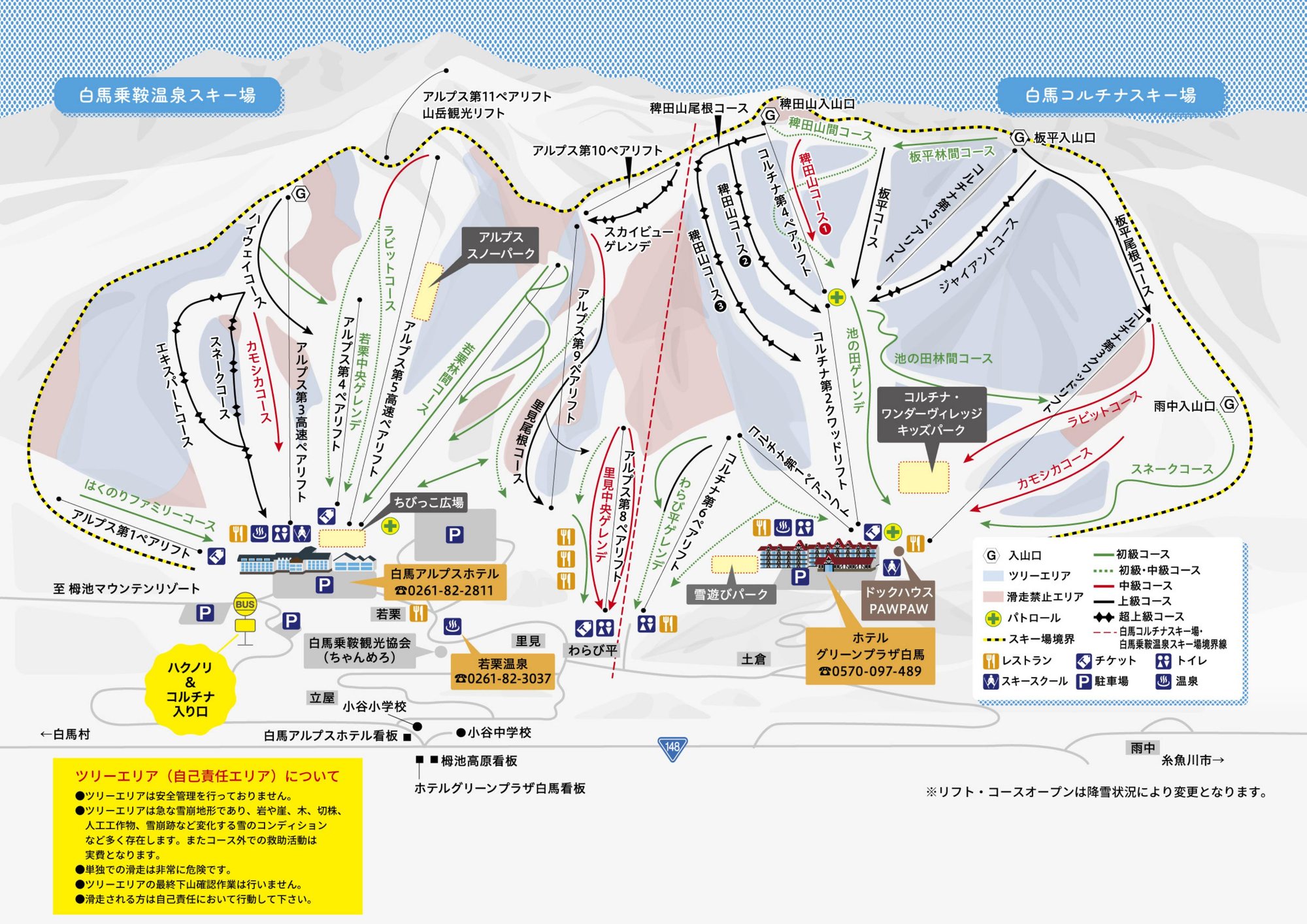 點圖看大圖Tap to enlarge
官方 PDF 轉成圖片。Converted from the official PDF.
圖片來源:雪場官方Image source: official ski field · 著作權屬各雪場,本站僅縮小轉載供參考。Copyright belongs to the resort; shown reduced for reference only.
3D 雪場地圖3D map
全螢幕 / 新分頁開啟Full screen / new tab拖曳旋轉、滾輪或雙指縮放。3D 地圖為非官方,地形來自 Mapterhorn,底圖為 OpenFreeMap,可切換國土地理院空拍圖,雪道與纜車來自 OpenStreetMap,收錄在「中部 3D 雪場地圖版本庫」(3DChubu-0010)。手機上有定位按鈕。Drag to rotate, scroll or pinch to zoom. Unofficial 3D map: terrain from Mapterhorn, OpenFreeMap basemap with a GSI aerial photo toggle, runs and lifts from OpenStreetMap, published in the Chubu 3D library (3DChubu-0010). On phones there is a locate button. chubu-3d.pages.dev
出典:国土地理院(加工)・© OpenStreetMap contributors(ODbL)Source: Geospatial Information Authority of Japan (processed) · © OpenStreetMap contributors (ODbL)