戶隱Togakushi

雪場資訊Resort info

戶隱以正面山岳景觀與兩座山麓間多變地形取勝,官方雪道從家庭緩坡到饅頭、非壓雪均有安排,並可結合神社、蕎麥麵與地方住宿。少量顧客評價喜歡硬實整理雪面的轉彎感,也指出看似陡峭的正面之外仍有不少緩坡。適合兼顧技術練習與文化行程的人;晴景、雪質與巴士安排各有條件,不應從一張山景照推定全山難度。Togakushi pairs striking mountain views with terrain spread across two mountainsides. Official information ranges from family slopes to moguls and ungroomed challenges, while the surrounding shrine and soba culture gives a visit a strong local identity. A few customers enjoy firm prepared surfaces and point out that the intimidating-looking front face does not represent all the available terrain. It suits a trip combining technique and regional culture, with weather, transport and route choice determining the day's experience more than a single scenic photograph.
- 縣/地區Prefecture / area
- 長野縣 · 長野市Nagano
- 標高/落差Elevation / vertical
- 山腳 1,220 m・山頂 1,748 m・垂直 448 mBase 1,220 m · top 1,748 m · vertical 448 m來源source
- 纜車Lifts
- 7 座7來源source
- 最長滑道Longest run
- 3 km來源source
- 2026-27 開放日2026-27 opening
- 2026-12-12 至 2027-03-31(官網)2026-12-12 to 2027-03-31 (official site)來源source
- 地形公園Terrain park
- 有:有戶隱 Wave Park、戶隱雪板 Park,另有兒童用的忍者雪道與 Kids ParkYes: Togakushi Wave Park and Yukiita (snow-deck) Park, plus the Ninja Slope and a kids park來源source
- 營業時間Hours
- 8:30–16:158:30–16:15來源source
- 夜間滑雪Night skiing
- 無None來源source
- 定休日Closing days
- 未整理Not compiled yet
- 票價Lift prices
大人Adult 長者Senior 兒童Child 1 日券1 day ¥7,000 ¥6,000 ¥4,500 2 日券2 days ¥13,000 ¥11,000 ¥8,200 SnowJapan 2026-27 季價格;年齡分級依雪場規定,部分雪場另有高中生等票種,請以官網為準。SnowJapan 2026-27 prices. Age bands follow each resort; some resorts have extra categories such as high-school tickets. Check the official site.
來源source
雪道圖Trail map
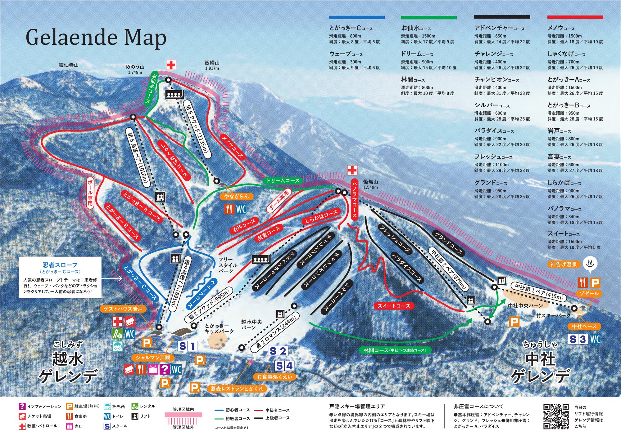 點圖看大圖Tap to enlarge
官網雪道圖 PDF(2022 年版)第 1 頁轉成圖片。Page 1 of the official gelände map PDF (2022 edition), rasterised.
圖片來源:雪場官方Image source: official ski field · 著作權屬各雪場,本站僅縮小轉載供參考。Copyright belongs to the resort; shown reduced for reference only.
3D 雪場地圖3D map
全螢幕 / 新分頁開啟Full screen / new tab拖曳旋轉、滾輪或雙指縮放。3D 地圖為非官方,地形來自 Mapterhorn,底圖為 OpenFreeMap,可切換國土地理院空拍圖,雪道與纜車來自 OpenStreetMap,收錄在「中部 3D 雪場地圖版本庫」(3DChubu-0010)。手機上有定位按鈕。Drag to rotate, scroll or pinch to zoom. Unofficial 3D map: terrain from Mapterhorn, OpenFreeMap basemap with a GSI aerial photo toggle, runs and lifts from OpenStreetMap, published in the Chubu 3D library (3DChubu-0010). On phones there is a locate button. chubu-3d.pages.dev
出典:国土地理院(加工)・© OpenStreetMap contributors(ODbL)Source: Geospatial Information Authority of Japan (processed) · © OpenStreetMap contributors (ODbL)