飯綱 Iizuna ResortIizuna Resort

雪場資訊Resort info

飯綱 Iizuna Resort 把長線、寬坡與夜滑結合,官方並有獨立兒童區,讓家庭與技術練習可各取所需。少量顧客評價覺得雪道方向容易理解,也有人在新雪後享受良好坡面;但上部吊椅未開及饅頭坡難度亦被提及。其優點是近郊時段彈性與多種坡面,而非所有路線都平緩;須分清雪場、餐廳的營業日與當季夜滑安排。Iizuna Resort combines longer runs, broad prepared slopes and evening skiing, with an officially separate children's area. That gives families and technique-minded skiers different ways to use the same mountain. A few visitors find the layout easy to follow and enjoy good surfaces after snowfall, while others encounter an unavailable upper lift or challenging moguls. Its strength is flexible local skiing rather than uniformly gentle terrain. Confirm mountain, restaurant and evening schedules separately, since their operating arrangements are not necessarily identical.
- 縣/地區Prefecture / area
- 長野縣 · 上水內郡飯綱町大字川上2755-209Nagano
- 標高/落差Elevation / vertical
- 山腳 900 m・山頂 1,500 m・垂直 600 mBase 900 m · top 1,500 m · vertical 600 m來源source
- 纜車Lifts
- 3 座3來源source
- 最長滑道Longest run
- 2.5 km來源source
- 2026-27 開放日2026-27 opening
- 2026-12-24 至 2027-03-22(預定;官網)2026-12-24 to 2027-03-22 (planned; official site)來源source
- 地形公園Terrain park
- SnowJapan 與官網只提到兒童用的 Kids Park Land,未提到地形公園SnowJapan and the official site list only the Kids Park Land, no terrain park來源source
- 營業時間Hours
- 日間 8:30–16:00;山頂第 4 雙人吊椅平日不一定運行Daytime 8:30–16:00; the top No. 4 pair lift does not run every weekday來源source
- 夜間滑雪Night skiing
- 有:18:00–22:00,2026-12-25 起,並非每天(日期見官網)Yes: 18:00–22:00 from 25 Dec 2026, not every day (dates on the official site)來源source
- 定休日Closing days
- 未整理Not compiled yet
- 票價Lift prices
大人Adult 長者Senior 兒童Child 日間 1 日券Day 1 day ¥4,800 ¥4,300 ¥2,800 夜間 4 小時券Night 4 hours ¥4,100 ¥4,100 ¥2,200 官網 2026-27 季價格(週末假日同價)。Official 2026-27 prices (same on weekends and holidays).
來源source
雪道圖Trail map
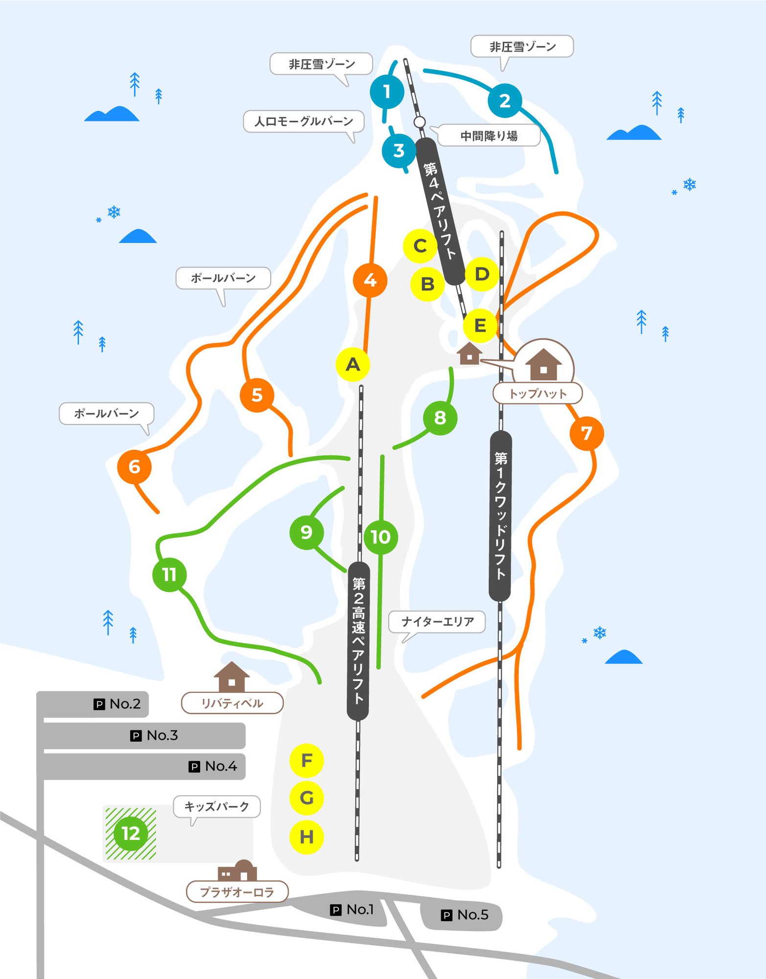 點圖看大圖Tap to enlarge
圖片來源:Snowline(snowline.jp)Image source: Snowline (snowline.jp) · 著作權屬各雪場,本站僅縮小轉載供參考。Copyright belongs to the resort; shown reduced for reference only.
3D 雪場地圖3D map
全螢幕 / 新分頁開啟Full screen / new tab拖曳旋轉、滾輪或雙指縮放。3D 地圖為非官方,地形來自 Mapterhorn,底圖為 OpenFreeMap,可切換國土地理院空拍圖,雪道與纜車來自 OpenStreetMap,收錄在「中部 3D 雪場地圖版本庫」(3DChubu-0010)。手機上有定位按鈕。Drag to rotate, scroll or pinch to zoom. Unofficial 3D map: terrain from Mapterhorn, OpenFreeMap basemap with a GSI aerial photo toggle, runs and lifts from OpenStreetMap, published in the Chubu 3D library (3DChubu-0010). On phones there is a locate button. chubu-3d.pages.dev
出典:国土地理院(加工)・© OpenStreetMap contributors(ODbL)Source: Geospatial Information Authority of Japan (processed) · © OpenStreetMap contributors (ODbL)