白馬岩岳Hakuba Iwatake

雪場資訊Resort info

白馬岩岳的特色是獨立山體帶來的環視北阿爾卑斯景觀,以及向不同方向延伸的自然地形雪道,官方亦有景觀休憩與非滑雪選擇。有限顧客評價喜歡路線多樣與纜車,但對部分設施看法不一;較近紀錄即使欣賞山景,也遇上薄雪露土。它適合把滑行與風景同等看重的人,不能用觀光設施的熱度代替對雪況與路線開放的查核。Hakuba Iwatake's independent summit creates a distinctive panorama of the Northern Alps, with official terrain extending in several directions around the mountain. Scenic breaks and non-skiing options add to its appeal. The limited customer sample enjoys varied courses and the gondola but is mixed about other facilities; a recent log admires the views while encountering thin cover and exposed ground. It is particularly attractive when scenery matters as much as skiing, provided sightseeing popularity is not mistaken for reliable snow on every course.
- 縣/地區Prefecture / area
- 長野縣 · 白馬村Hakuba · Nagano
- 標高/落差Elevation / vertical
- 山腳 750 m・山頂 1,289 m・垂直 539 mBase 750 m · top 1,289 m · vertical 539 m來源source
- 纜車Lifts
- 8 座8來源source
- 最長滑道Longest run
- 3.8 km來源source
- 2026-27 開放日2026-27 opening
- 未整理Not compiled yet
- 地形公園Terrain park
- 有:冬季設有 DC PARK。Yes: DC PARK in winter.來源source
- 票價Lift prices
- 未整理Not compiled yet
雪道圖Trail map
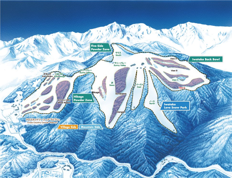 點圖看大圖Tap to enlarge
圖片來源:Snowline(snowline.jp)Image source: Snowline (snowline.jp) · 著作權屬各雪場,本站僅縮小轉載供參考。Copyright belongs to the resort; shown reduced for reference only.
3D 雪場地圖3D map
全螢幕 / 新分頁開啟Full screen / new tab拖曳旋轉、滾輪或雙指縮放。3D 地圖為非官方,地形來自 Mapterhorn,底圖為 OpenFreeMap,可切換國土地理院空拍圖,雪道與纜車來自 OpenStreetMap,收錄在「中部 3D 雪場地圖版本庫」(3DChubu-0010)。手機上有定位按鈕。Drag to rotate, scroll or pinch to zoom. Unofficial 3D map: terrain from Mapterhorn, OpenFreeMap basemap with a GSI aerial photo toggle, runs and lifts from OpenStreetMap, published in the Chubu 3D library (3DChubu-0010). On phones there is a locate button. chubu-3d.pages.dev
出典:国土地理院(加工)・© OpenStreetMap contributors(ODbL)Source: Geospatial Information Authority of Japan (processed) · © OpenStreetMap contributors (ODbL)