志賀高原全山Shiga Kogen (all mountain)

雪場資訊Resort info

志賀高原全山是一組分布高原的滑區,不應理解為單一山腳出發、全程無縫滑遍的雪場。官方強調多區雪道、高海拔與全山探索潛力,適合願意研究交通、票券及區域差異的旅客。可核實顧客評價只涵蓋部分區域,有人喜歡少候車與新雪,也有人遇到學校團體;不能外推成全山共同結論。其優勢在選擇廣,而非一次走遍所有地形。Shiga Kogen is a collection of highland ski sectors, not one simple mountain that can all be explored seamlessly from a single base. Official information emphasises its breadth, elevation and variety, rewarding skiers who study transport, passes and regional differences. The verified customer evidence here concerns selected sectors only: some visits enjoy little waiting and fresh snow, while another encounters substantial school-group traffic. Its strength is the range of choices across a larger destination, not a universal experience shared by every area.
- 縣/地區Prefecture / area
- 長野縣 · 山之內町Yamanouchi · Nagano
- 標高/落差Elevation / vertical
- 未整理Not compiled yet來源source
- 纜車Lifts
- 24 座24來源source
- 最長滑道Longest run
- 未整理Not compiled yet來源source
- 2026-27 開放日2026-27 opening
- 2026-12-05(聯票;各場區不同)2026-12-05 (joint ticket; areas vary)來源source
- 地形公園Terrain park
- 未整理Not compiled yet
- 票價Lift prices
大人Adult シニアSenior 兒童Child 1 日券(窓口)1-day (窓口) ¥9,500 — — 2026-27 大人 1 日券,日圓。JAPANSNOWLINE 於 10/19 對照官網確認;長者與兒童票價未整理,請以官網為準。2026-27 adult 1-day ticket in yen, checked against the official site by JAPANSNOWLINE on 10/19. Senior and child prices not yet compiled; check the official site.
來源source
雪道圖Trail map
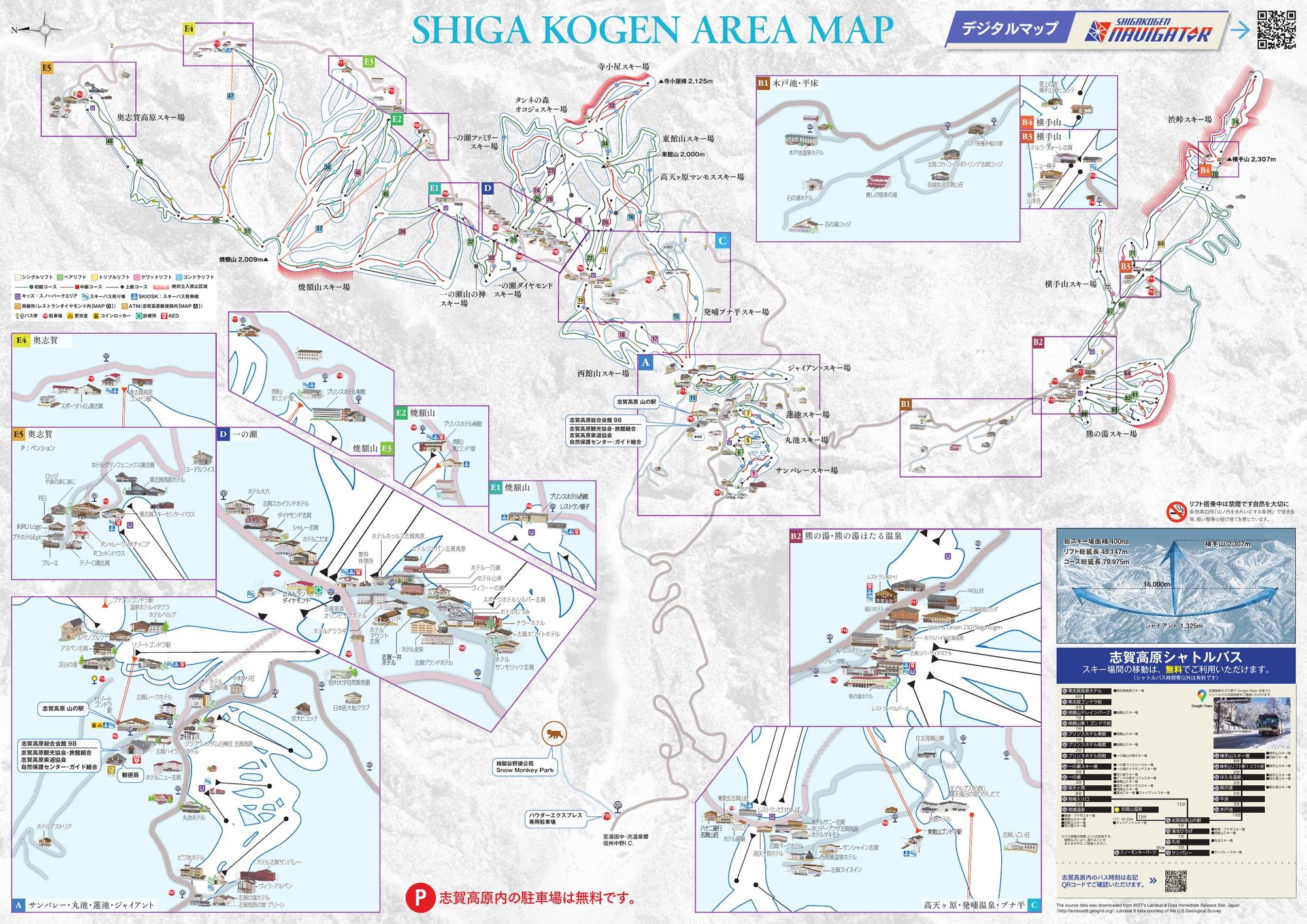 點圖看大圖Tap to enlarge
官方 PDF 轉成圖片。Converted from the official PDF.
圖片來源:雪場官方Image source: official ski field · 著作權屬各雪場,本站僅縮小轉載供參考。Copyright belongs to the resort; shown reduced for reference only.
3D 雪場地圖3D map
全螢幕 / 新分頁開啟Full screen / new tab拖曳旋轉、滾輪或雙指縮放。3D 地圖為非官方,地形來自 Mapterhorn,底圖為 OpenFreeMap,可切換國土地理院空拍圖,雪道與纜車來自 OpenStreetMap,收錄在「中部 3D 雪場地圖版本庫」(3DChubu-0010)。手機上有定位按鈕。Drag to rotate, scroll or pinch to zoom. Unofficial 3D map: terrain from Mapterhorn, OpenFreeMap basemap with a GSI aerial photo toggle, runs and lifts from OpenStreetMap, published in the Chubu 3D library (3DChubu-0010). On phones there is a locate button. chubu-3d.pages.dev
出典:国土地理院(加工)・© OpenStreetMap contributors(ODbL)Source: Geospatial Information Authority of Japan (processed) · © OpenStreetMap contributors (ODbL)