八方尾根Hakuba Happo-One

雪場資訊Resort info

八方尾根以北阿爾卑斯大景、長落差與經典饅頭坡形成鮮明個性,官方也保留較緩初級區,適合按程度分區而非籠統判斷全山。少量顧客評價肯定整理雪道與山上餐飲,同時提醒午後結冰及巴士抵達後轉乘時間。這裡尤其適合願意挑戰連續中坡、起伏與長線的滑雪者;初學者不宜只因有綠線,就假設任何山頂回程都容易。Happo-One combines major Northern Alps scenery with substantial vertical, classic moguls and long, sustained skiing. Official information also identifies gentler introductory areas, so the mountain deserves a sector-by-sector assessment rather than one blanket difficulty label. A few customers appreciate the grooming and mountain food, while others note afternoon refreezing or extra transfer time after arriving by bus. It is particularly compelling for confident skiers seeking continuous intermediate terrain and technical challenges; beginner facilities do not make every upper-mountain descent straightforward.
- 縣/地區Prefecture / area
- 長野縣 · 白馬村Hakuba · Nagano
- 標高/落差Elevation / vertical
- 山腳 760 m・山頂 1,831 m・垂直 1,071 mBase 760 m · top 1,831 m · vertical 1,071 m來源source
- 纜車Lifts
- 21 座21來源source
- 最長滑道Longest run
- 8 km來源source
- 2026-27 開放日2026-27 opening
- 2026-12-012026-12-01來源source
- 地形公園Terrain park
- 有:HAPPO PARKS(由 THE PARKS 營運的自由式公園)。Yes: HAPPO PARKS, run by THE PARKS.來源source
- 票價Lift prices
大人Adult 長者Senior 兒童Child 1 日券1-day ¥9,800 ¥9,500 ¥4,900 2026-27 雪季 1 日券,日圓,取自 SnowJapan(整理自官網)。原文分級:Adult: 9,800 yen;Child: 4,900 yen;Senior: 9,500 yen。2026-27 1-day ticket in yen, from SnowJapan (compiled from the official site). Categories as listed: Adult: 9,800 yen; Child: 4,900 yen; Senior: 9,500 yen.
來源source
雪道圖Trail map
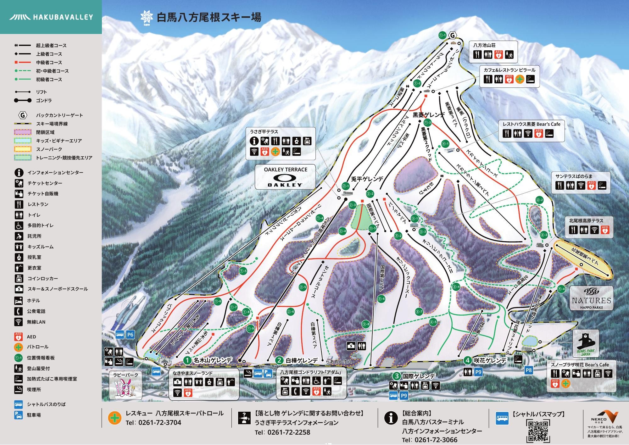 點圖看大圖Tap to enlarge
官方 PDF 轉成圖片。Converted from the official PDF.
圖片來源:雪場官方Image source: official ski field · 著作權屬各雪場,本站僅縮小轉載供參考。Copyright belongs to the resort; shown reduced for reference only.
3D 雪場地圖3D map
全螢幕 / 新分頁開啟Full screen / new tab拖曳旋轉、滾輪或雙指縮放。3D 地圖為非官方,地形來自 Mapterhorn,底圖為 OpenFreeMap,可切換國土地理院空拍圖,雪道與纜車來自 OpenStreetMap,收錄在「中部 3D 雪場地圖版本庫」(3DChubu-0010)。手機上有定位按鈕。Drag to rotate, scroll or pinch to zoom. Unofficial 3D map: terrain from Mapterhorn, OpenFreeMap basemap with a GSI aerial photo toggle, runs and lifts from OpenStreetMap, published in the Chubu 3D library (3DChubu-0010). On phones there is a locate button. chubu-3d.pages.dev
出典:国土地理院(加工)・© OpenStreetMap contributors(ODbL)Source: Geospatial Information Authority of Japan (processed) · © OpenStreetMap contributors (ODbL)