熊之湯Kumanoyu

雪場資訊Resort info
熊之湯的特色是高原環境中的集中式練習雪場,官方提供多種坡度與長雪季資訊,適合以固定區域累積技術而不急於跨越整個志賀。有限顧客分享喜歡新雪日及饅頭坡、旗門練習的組合,顯示小範圍也能有充實內容。這些經驗不等於每天粉雪;與橫手山的連接、早晚場及季末雪面須按當季公告確認,不能把全山票當作運輸保證。Kumanoyu offers concentrated practice skiing in Shiga Kogen's highland environment. Official information covers varied gradients and an extended seasonal offering, making it appealing to skiers happy to learn one area thoroughly. The limited visitor sample enjoys fresh-snow days and a combination of moguls, gate practice and forested runs. Its compact footprint can still provide a full session. Check links toward Yokoteyama and any early, late or spring arrangements separately; a wider-area pass does not guarantee that every connecting lift or route will operate.
- 縣/地區Prefecture / area
- 長野縣 · 山之內町Yamanouchi · Nagano
- 標高/落差Elevation / vertical
- 山腳 1,690 m・山頂 1,950 m・垂直 260 mBase 1,690 m · top 1,950 m · vertical 260 m來源source
- 纜車Lifts
- 5 座5來源source
- 最長滑道Longest run
- 1.3 km來源source
- 2026-27 開放日2026-27 opening
- 2026-11-142026-11-14來源source
- 地形公園Terrain park
- 未整理Not compiled yet
- 票價Lift prices
- 未整理Not compiled yet
雪道圖Trail map
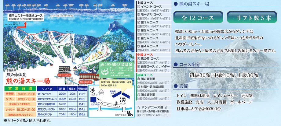 點圖看大圖Tap to enlarge
圖片來源:Snowline(snowline.jp)Image source: Snowline (snowline.jp) · 著作權屬各雪場,本站僅縮小轉載供參考。Copyright belongs to the resort; shown reduced for reference only.
3D 雪場地圖3D map
全螢幕 / 新分頁開啟Full screen / new tab拖曳旋轉、滾輪或雙指縮放。3D 地圖為非官方,地形來自 Mapterhorn,底圖為 OpenFreeMap,可切換國土地理院空拍圖,雪道與纜車來自 OpenStreetMap,收錄在「中部 3D 雪場地圖版本庫」(3DChubu-0010)。手機上有定位按鈕。Drag to rotate, scroll or pinch to zoom. Unofficial 3D map: terrain from Mapterhorn, OpenFreeMap basemap with a GSI aerial photo toggle, runs and lifts from OpenStreetMap, published in the Chubu 3D library (3DChubu-0010). On phones there is a locate button. chubu-3d.pages.dev
出典:国土地理院(加工)・© OpenStreetMap contributors(ODbL)Source: Geospatial Information Authority of Japan (processed) · © OpenStreetMap contributors (ODbL)