田澤湖Tazawako

雪場資訊Resort info

田澤湖雪場以面向深藍湖面的開闊景觀最具辨識度,官方雪道配置兼有寬坡、較陡路線與練習區,適合把風景與技術滑行結合。少量顧客評價特別喜歡寬廣坡面的刻滑感,也有近期訪客稱讚高處眺望田澤湖。這些優點仍需天氣配合;降雪視線不良與春季重雪也見於紀錄,不能只看晴日照片推定每日條件。Tazawako's defining feature is skiing above the striking blue lake, with official terrain information offering wide slopes, steeper courses and practice options. A few customer reviews particularly enjoy the open pistes for carving, and a recent visitor praises the lake outlook from higher terrain. That combination gives it a clear identity beyond simply being another snowy mountain. Heavy snowfall can obscure slope boundaries and views, while spring logs describe tiring wet snow, so the scenic promise remains weather-dependent.
- 縣/地區Prefecture / area
- 秋田縣 · 仙北市Semboku · Akita
- 標高/落差Elevation / vertical
- 山腳 578 m・山頂 1,186 m・垂直 608 mBase 578 m · top 1,186 m · vertical 608 m來源source
- 纜車Lifts
- 6 座6來源source
- 最長滑道Longest run
- 3 km來源source
- 2026-27 開放日2026-27 opening
- 2026-12-192026-12-19來源source
- 地形公園Terrain park
- 有:Snow Park有kicker等,另有 mini cross 賽道Yes: Snow park with kickers, plus mini-cross course來源source
- 票價Lift prices
大人Adult 長者Senior 兒童Child 1 日券1-day ¥5,800 ¥4,800 ¥1,900 2026-27 雪季 1 日券,日圓,取自 SnowJapan(整理自官網)。原文分級:Adult: 5,800 yen;Child (elementary): 1,900 yen;Child (high school): 3,600 yen;Senior (60+): 4,800 yen。2026-27 1-day ticket in yen, from SnowJapan (compiled from the official site). Categories as listed: Adult: 5,800 yen; Child (elementary): 1,900 yen; Child (high school): 3,600 yen; Senior (60+): 4,800 yen.
來源source
雪道圖Trail map
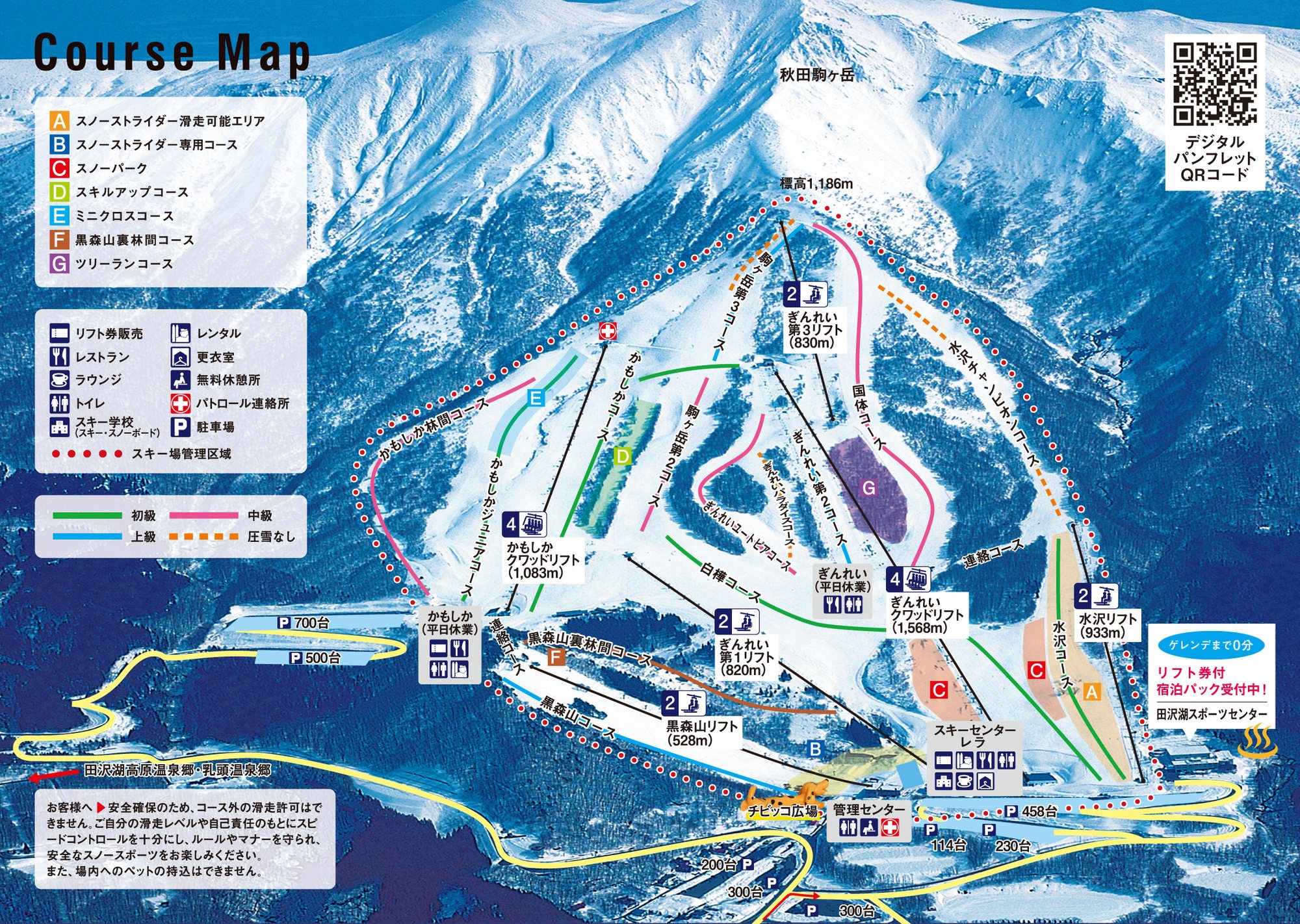 點圖看大圖Tap to enlarge
圖片來源:Snowline(snowline.jp)Image source: Snowline (snowline.jp) · 著作權屬各雪場,本站僅縮小轉載供參考。Copyright belongs to the resort; shown reduced for reference only.
3D 雪場地圖3D map
全螢幕 / 新分頁開啟Full screen / new tab拖曳旋轉、滾輪或雙指縮放。3D 地圖為非官方,地形來自 Mapterhorn,底圖為 OpenFreeMap,可切換國土地理院空拍圖,雪道與纜車來自 OpenStreetMap,收錄在「東北 3D 雪場地圖版本庫」(3DMap-0015)。手機上有定位按鈕。Drag to rotate, scroll or pinch to zoom. Unofficial 3D map: terrain from Mapterhorn, OpenFreeMap basemap with a GSI aerial photo toggle, runs and lifts from OpenStreetMap, published in the Tohoku 3D library (3DMap-0015). On phones there is a locate button. tohoku-3d.pages.dev
出典:国土地理院(加工)・© OpenStreetMap contributors(ODbL)Source: Geospatial Information Authority of Japan (processed) · © OpenStreetMap contributors (ODbL)
附近溫泉Nearby onsen
露天風呂 水澤溫泉Mizusawa Onsen Rotenburo
田澤湖高原乳白露天Milky outdoor bath on Tazawako plateau
橫手站前溫泉 Yuyu PlazaYokote Ekimae Onsen Yuyu Plaza
橫手站前溫泉與岩盤浴Onsen & stone spa by Yokote Station
餐廳Food
飛魚湯稻庭烏龍麵 古泉洞Kosendo
推薦Try 稻庭烏龍麵
角館飛魚湯底稻庭烏龍Inaniwa udon in flying-fish broth