栗駒 JeunesseJeunesse Kurikoma

雪場資訊Resort info

栗駒 Jeunesse 的特色是較開闊的中坡與反覆練習的滑行節奏,官方保留家庭用吊椅票與地方雪場配套。可讀的主要完整評價較舊,稱讚寬廣開放坡、舒適中坡及吊椅周轉;較新滑行紀錄則證實仍有人在此參與技術檢定或季末滑行。它值得以地形與地方氛圍認識,但舊評價的設施描述不能當作新季全面運作保證。Jeunesse Kurikoma is appealing for open-slope skiing and repeatable intermediate practice in a regional setting. Official information retains family-oriented ticket options and local resort facilities. The most descriptive readable review is older, praising broad open terrain, comfortable gradients and efficient lift laps. More recent ski logs document technique-related visits and late-season outings. Those sources support its practice-oriented character, but the older account should not be treated as confirmation that every lift or facility will operate unchanged in the coming winter.
- 縣/地區Prefecture / area
- 秋田縣 · 雄勝郡東成瀬村Akita
- 標高/落差Elevation / vertical
- 山腳 395 m・山頂 770 m・垂直 375 mBase 395 m · top 770 m · vertical 375 m來源source
- 纜車Lifts
- 3 座3來源source
- 最長滑道Longest run
- 2.5 km來源source
- 2026-27 開放日2026-27 opening
- 未整理Not compiled yet
- 地形公園Terrain park
- 沒有專門的地形公園;山腳附近有 wave 雪道,上段有幾處不壓雪的粉雪區No dedicated park; a wave course near the base and a few ungroomed powder zones higher up來源source
- 營業時間Hours
- 9:00–16:00(第 1 雙人吊椅通常只在週五、週末與假日運行)9:00–16:00 (No. 1 pair lift usually Fridays, weekends and holidays only)來源source
- 夜間滑雪Night skiing
- 無None來源source
- 定休日Closing days
- 無定休日(官網營業案內,2025-26 季)No regular closing days (official guide, 2025-26)
- 票價Lift prices
大人Adult 長者Senior 兒童Child 1 日券1 day ¥4,000 — ¥1,500 單次搭乘券1 lift coupon ¥600 — ¥400 SnowJapan 只有 2025-26 季的價格(2026-27 季尚未公布),僅供參考。年齡分級依雪場規定,部分雪場另有高中生等票種,請以官網為準。SnowJapan only lists 2025-26 prices (2026-27 not announced yet); for reference only. Age bands follow each resort; some resorts have extra categories such as high-school tickets. Check the official site.
來源source
雪道圖Trail map
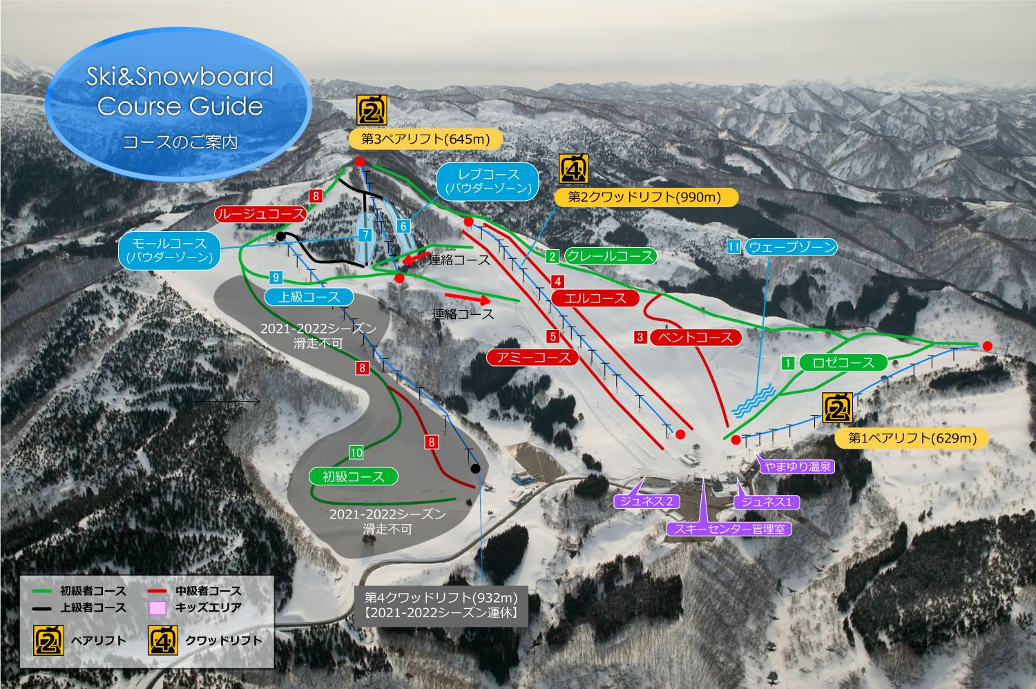 點圖看大圖Tap to enlarge
圖片來源:Snowline(snowline.jp)Image source: Snowline (snowline.jp) · 著作權屬各雪場,本站僅縮小轉載供參考。Copyright belongs to the resort; shown reduced for reference only.
3D 雪場地圖3D map
全螢幕 / 新分頁開啟Full screen / new tab拖曳旋轉、滾輪或雙指縮放。3D 地圖為非官方,地形來自 Mapterhorn,底圖為 OpenFreeMap,可切換國土地理院空拍圖,雪道與纜車來自 OpenStreetMap,收錄在「東北 3D 雪場地圖版本庫」(3DMap-0015)。手機上有定位按鈕。Drag to rotate, scroll or pinch to zoom. Unofficial 3D map: terrain from Mapterhorn, OpenFreeMap basemap with a GSI aerial photo toggle, runs and lifts from OpenStreetMap, published in the Tohoku 3D library (3DMap-0015). On phones there is a locate button. tohoku-3d.pages.dev
出典:国土地理院(加工)・© OpenStreetMap contributors(ODbL)Source: Geospatial Information Authority of Japan (processed) · © OpenStreetMap contributors (ODbL)