鬼首Onikobe

雪場資訊Resort info

鬼首的特色是山腳與高處不同風貌的路線,官方冬季資訊與山區配置,適合喜歡變化而不只重複單一大坡的人。少量顧客評價肯定雪道選擇與高處山景,也有人在新雪日享受到較高處的粉雪;但初級迂迴線可能狹窄、曲折。旅程應按程度分配路線,並注意冬季道路與纜車開放,不宜只看地圖便假設所有連接都容易。Onikobe's attraction is the contrast between its lower terrain and higher mountain skiing. Official winter information and the course layout provide a setting for a varied day rather than repeated laps on one broad face. A few visitors enjoy the different routes and upper-mountain scenery, with recent logs finding better fresh snow higher up. Some beginner detours are described as narrow and winding, however. Choose routes for the group's ability and verify winter road access and operating lifts before arrival.
- 縣/地區Prefecture / area
- 宮城縣大崎市Osaki · Miyagi
- 標高/落差Elevation / vertical
- 山腳 340 m・山頂 1,055 m・垂直 715 mBase 340 m · top 1,055 m · vertical 715 m來源source
- 纜車Lifts
- 6 座6來源source
- 最長滑道Longest run
- 3 km來源source
- 2026-27 開放日2026-27 opening
- 未公布Not announced來源source
- 地形公園Terrain park
- 有:設有公園:kicker、箱子Yes: Park with kickers and boxes來源source
- 票價Lift prices
- 未整理Not compiled yet
雪道圖Trail map
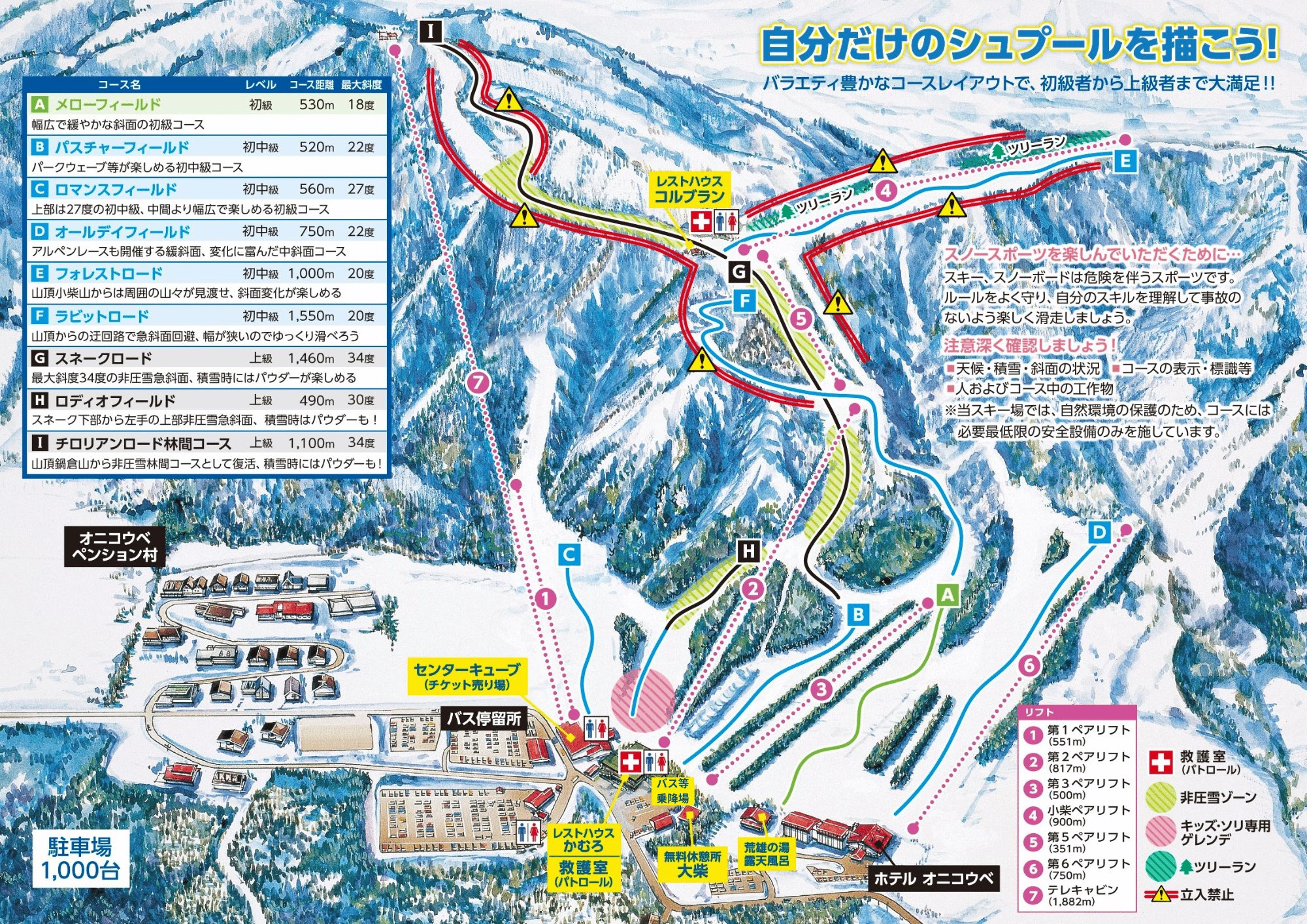 點圖看大圖Tap to enlarge
圖片來源:Snowline(snowline.jp)Image source: Snowline (snowline.jp) · 著作權屬各雪場,本站僅縮小轉載供參考。Copyright belongs to the resort; shown reduced for reference only.
3D 雪場地圖3D map
全螢幕 / 新分頁開啟Full screen / new tab拖曳旋轉、滾輪或雙指縮放。3D 地圖為非官方,地形來自 Mapterhorn,底圖為 OpenFreeMap,可切換國土地理院空拍圖,雪道與纜車來自 OpenStreetMap,收錄在「東北 3D 雪場地圖版本庫」(3DMap-0015)。手機上有定位按鈕。Drag to rotate, scroll or pinch to zoom. Unofficial 3D map: terrain from Mapterhorn, OpenFreeMap basemap with a GSI aerial photo toggle, runs and lifts from OpenStreetMap, published in the Tohoku 3D library (3DMap-0015). On phones there is a locate button. tohoku-3d.pages.dev
出典:国土地理院(加工)・© OpenStreetMap contributors(ODbL)Source: Geospatial Information Authority of Japan (processed) · © OpenStreetMap contributors (ODbL)
附近溫泉Nearby onsen
東根溫泉 小松之湯Higashine Onsen Komatsu-no-yu
東根日歸溫泉Day onsen in Higashine