森吉山阿仁Moriyoshi-zan Ani

雪場資訊Resort info

森吉山阿仁把滑雪與樹冰觀賞結合,官方介紹纜車山頂附近的樹冰區,讓晴好天氣下的山岳景觀成為重要主角。少量顧客評價喜歡滑累後轉換到樹冰欣賞,也有人在降雪日記下深雪體驗。其優點是自然景觀與滑行同時具備,不是龐大雪道數;部分連接路段可能平緩甚至需移動,風雪與能見度亦會影響體驗。Moriyoshi-zan Ani combines skiing with access to its distinctive rime-covered trees. Official information locates the viewing area near the upper gondola station, making scenery a substantial part of the outing. A few visitors appreciate switching from skiing to tree viewing, and recent logs record deep-snow days. Its strength is that blend of mountain atmosphere and skiing rather than an enormous piste count. Some connecting sections can require extra movement, while wind and visibility can determine how much of the scenery is actually enjoyed.
- 縣/地區Prefecture / area
- 秋田縣 · 北秋田市Kitaakita · Akita
- 標高/落差Elevation / vertical
- 山腳 537 m・山頂 1,200 m・垂直 663 mBase 537 m · top 1,200 m · vertical 663 m來源source
- 纜車Lifts
- 3 座3來源source
- 最長滑道Longest run
- 4.4 km來源source
- 2026-27 開放日2026-27 opening
- 12/12 開放(預定,視降雪而定)Opens 12/12 (planned, snow permitting)來源source
- 地形公園Terrain park
- 官方未見公園資訊,以樹冰為主No park info on official site; known for snow monsters來源source
- 票價Lift prices
大人Adult 長者Senior 兒童Child 1 日券1-day ¥5,000 ¥4,000 ¥2,000 2026-27 雪季 1 日券,日圓,取自 SnowJapan(整理自官網)。原文分級:Adult: 5,000 yen;Child: 2,000 yen;Senior: 4,000 yen。2026-27 1-day ticket in yen, from SnowJapan (compiled from the official site). Categories as listed: Adult: 5,000 yen; Child: 2,000 yen; Senior: 4,000 yen.
來源source
雪道圖Trail map
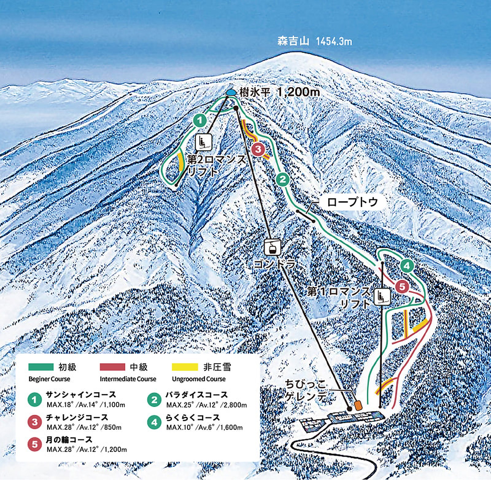 點圖看大圖Tap to enlarge
原圖解析度較低,已放大處理,細節可能略糊Low-res original, upscaled; fine detail may be soft
圖片來源:雪場官方Image source: official ski field · 著作權屬各雪場,本站僅縮小轉載供參考。Copyright belongs to the resort; shown reduced for reference only.
3D 雪場地圖3D map
全螢幕 / 新分頁開啟Full screen / new tab拖曳旋轉、滾輪或雙指縮放。3D 地圖為非官方,地形來自 Mapterhorn,底圖為 OpenFreeMap,可切換國土地理院空拍圖,雪道與纜車來自 OpenStreetMap,收錄在「東北 3D 雪場地圖版本庫」(3DMap-0015)。手機上有定位按鈕。Drag to rotate, scroll or pinch to zoom. Unofficial 3D map: terrain from Mapterhorn, OpenFreeMap basemap with a GSI aerial photo toggle, runs and lifts from OpenStreetMap, published in the Tohoku 3D library (3DMap-0015). On phones there is a locate button. tohoku-3d.pages.dev
出典:国土地理院(加工)・© OpenStreetMap contributors(ODbL)Source: Geospatial Information Authority of Japan (processed) · © OpenStreetMap contributors (ODbL)
附近溫泉Nearby onsen
打當溫泉 Matagi之湯Utto Onsen Matagi-no-yu
阿仁獵人之鄉的祕境溫泉Remote onsen in matagi-hunter country
餐廳Food
秋田比內屋 大館本店Akita Hinaiya Odate
推薦Try 比內地雞米棒鍋
比內地雞與米棒鍋Hinai chicken & kiritanpo
Matagi之湯 ShikariShikari at Matagi-no-yu
推薦Try 熊肉鍋/馬肉
阿仁獵人料理熊鍋Matagi-style bear hotpot