星野 NekomaHoshino Resorts Nekoma Mountain

雪場資訊Resort info

Nekoma Mountain 把南北兩區整合成較大的滑行世界,官方以多樣雪道、公園及擴充樹林區為特色,南北季節安排亦不同。少量可核實評價主要來自北區,喜歡整理雪道與春季饅頭坡,足以支持技術練習的吸引力,但不足以代表全山服務或人潮。適合想長時間探索、又願意留意跨區連接的人;季末不可假設南區仍與北區同時開放。Nekoma Mountain combines northern and southern sectors into a broad skiing destination, with official information emphasising varied courses, parks and expanded tree zones. The two sides have different planned operating seasons. The limited customer evidence reviewed here is mainly from the northern sector, praising prepared slopes and spring mogul practice rather than establishing a verdict on the entire mountain. It appeals to skiers who want room to explore and develop skills, provided they check inter-sector access and do not assume both sides remain open equally late.
- 縣/地區Prefecture / area
- 福島縣 · 耶麻郡磐梯町/北塩原村Fukushima
- 標高/落差Elevation / vertical
- 山腳 700 m・山頂 1,337 m・垂直 637 mBase 700 m · top 1,337 m · vertical 637 m來源source
- 纜車Lifts
- 13 座13來源source
- 最長滑道Longest run
- 3 km來源source
- 2026-27 開放日2026-27 opening
- 北區 2026-11-28 至 2027-05-09,南區 2026-12-12 至 2027-04-04(官網)North area 28 Nov 2026 – 9 May 2027, South area 12 Dec 2026 – 4 Apr 2027 (official site)來源source
- 地形公園Terrain park
- 有:有多個地形公園區Yes: Several snow park areas來源source
- 營業時間Hours
- 吊椅一般 8:30–15:30Lifts usually 8:30–15:30來源source
- 夜間滑雪Night skiing
- 有:只在南區,1/9、1/10、1/16、1/23、1/30、2/6、2/13、2/20、2/27、3/6 的 16:30–20:00Yes: South area only, 16:30–20:00 on 9, 10, 16, 23, 30 Jan, 6, 13, 20, 27 Feb and 6 Mar來源source
- 定休日Closing days
- 未整理Not compiled yet
- 票價Lift prices
大人Adult 長者Senior 兒童Child 1 日券1 day ¥6,500 ¥6,000 ¥3,000 午後券Afternoon ¥4,900 — ¥2,200 SnowJapan 2026-27 季價格;年齡分級依雪場規定,部分雪場另有高中生等票種,請以官網為準。SnowJapan 2026-27 prices. Age bands follow each resort; some resorts have extra categories such as high-school tickets. Check the official site.
來源source
雪道圖Trail map
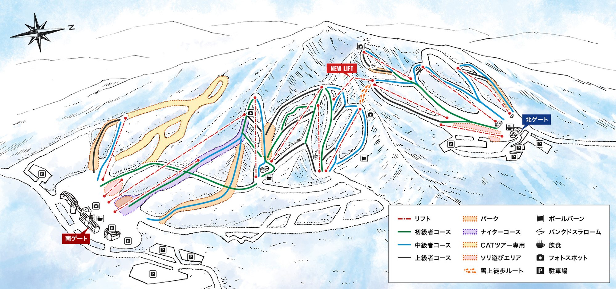 點圖看大圖Tap to enlarge
圖片來源:Snowline(snowline.jp)Image source: Snowline (snowline.jp) · 著作權屬各雪場,本站僅縮小轉載供參考。Copyright belongs to the resort; shown reduced for reference only.
3D 雪場地圖3D map
全螢幕 / 新分頁開啟Full screen / new tab拖曳旋轉、滾輪或雙指縮放。3D 地圖為非官方,地形來自 Mapterhorn,底圖為 OpenFreeMap,可切換國土地理院空拍圖,雪道與纜車來自 OpenStreetMap,收錄在「東北 3D 雪場地圖版本庫」(3DMap-0015)。手機上有定位按鈕。Drag to rotate, scroll or pinch to zoom. Unofficial 3D map: terrain from Mapterhorn, OpenFreeMap basemap with a GSI aerial photo toggle, runs and lifts from OpenStreetMap, published in the Tohoku 3D library (3DMap-0015). On phones there is a locate button. tohoku-3d.pages.dev
出典:国土地理院(加工)・© OpenStreetMap contributors(ODbL)Source: Geospatial Information Authority of Japan (processed) · © OpenStreetMap contributors (ODbL)