GrandecoGrandeco Snow Resort

雪場資訊Resort info

Grandeco 的特色是高處森林景觀與可連續滑行的長線,官方雪道包含較容易的 Main Street、樹林路線及更有挑戰的 Powder、The Rock。少量顧客評價稱讚旺季雪質,也喜歡有遮罩吊椅的舒適性;不過假期候車同樣被提及。適合想在較完整配套中兼顧進步與風景的人,仍應按程度選線,不能把全山長距離路線都當成初學坡。Grandeco pairs forested highland scenery with sustained skiing, and its official course guide distinguishes approachable Main Street from more demanding Powder and The Rock. A few customers praise midwinter snow and appreciate the shelter offered by hooded chairs. Holiday queues also feature in the same small sample. Its appeal is a combination of progression, scenery and practical resort facilities, rather than a uniformly easy mountain. Choose routes by their actual gradients and opening status, especially when moving beyond the main cruising terrain.
- 縣/地區Prefecture / area
- 福島縣 · 耶麻郡北塩原村Fukushima
- 標高/落差Elevation / vertical
- 山腳 580 m・山頂 1,590 m・垂直 1,010 mBase 580 m · top 1,590 m · vertical 1,010 m來源source
- 纜車Lifts
- 4 座4來源source
- 最長滑道Longest run
- 4.5 km來源source
- 2026-27 開放日2026-27 opening
- 2026-11-21 起預備季,12/12–2027-03-22 為主季,春季至 2027-04-11(官網)Pre-season from 21 Nov 2026, main season 12 Dec – 22 Mar 2027, spring season to 11 Apr 2027 (official site)來源source
- 地形公園Terrain park
- 有:有 Snow Surf Park、Free Ride Park 等五個區域Yes: Five areas including Snow Surf Park and Free Ride Park來源source
- 營業時間Hours
- 8:30–16:008:30–16:00來源source
- 夜間滑雪Night skiing
- 無None來源source
- 定休日Closing days
- 未整理Not compiled yet
- 票價Lift prices
大人Adult 長者Senior 兒童Child 1 日券(週末假日)1 day (weekends & holidays) ¥5,500 ¥4,800 ¥3,800 1 日券(平日)1 day (weekdays) ¥4,300 ¥3,800 ¥3,000 官網 2026-27 季價格。Official 2026-27 prices.
來源source
雪道圖Trail map
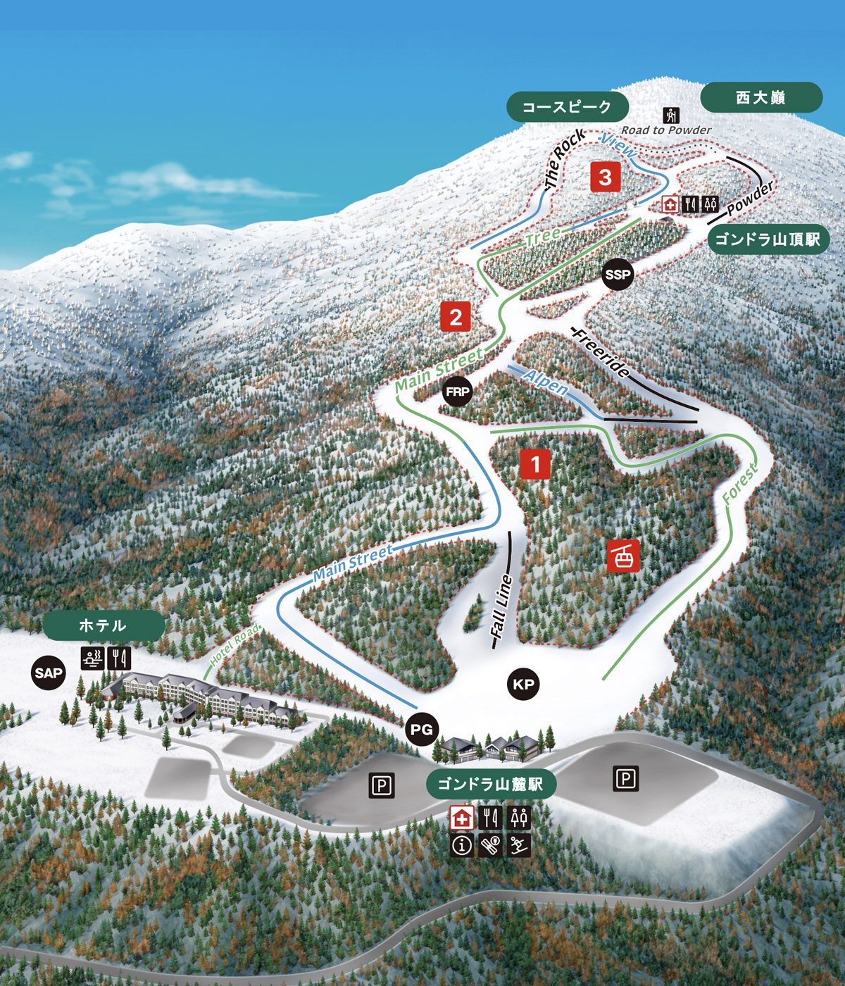 點圖看大圖Tap to enlarge
圖片來源:Snowline(snowline.jp)Image source: Snowline (snowline.jp) · 著作權屬各雪場,本站僅縮小轉載供參考。Copyright belongs to the resort; shown reduced for reference only.
3D 雪場地圖3D map
全螢幕 / 新分頁開啟Full screen / new tab拖曳旋轉、滾輪或雙指縮放。3D 地圖為非官方,地形來自 Mapterhorn,底圖為 OpenFreeMap,可切換國土地理院空拍圖,雪道與纜車來自 OpenStreetMap,收錄在「東北 3D 雪場地圖版本庫」(3DMap-0015)。手機上有定位按鈕。Drag to rotate, scroll or pinch to zoom. Unofficial 3D map: terrain from Mapterhorn, OpenFreeMap basemap with a GSI aerial photo toggle, runs and lifts from OpenStreetMap, published in the Tohoku 3D library (3DMap-0015). On phones there is a locate button. tohoku-3d.pages.dev
出典:国土地理院(加工)・© OpenStreetMap contributors(ODbL)Source: Geospatial Information Authority of Japan (processed) · © OpenStreetMap contributors (ODbL)