豬苗代Inawashiro

雪場資訊Resort info

豬苗代以俯瞰湖面的景觀與寬廣山坡滑行形成特色,官方亦提供影像紀錄、親子服務及夜間活動等度假選擇。少量顧客評價提及優惠制度帶來的彈性,也提醒硬雪時初學者較難控制、賽事會限制路線。其優點是湖景與完整日遊內容,不宜把促銷當成永久無條件免費;加入資格、日期與當季規則,以及實際開放區域都須先查。Inawashiro combines lake-facing skiing with an unusually extensive set of official photo, family and evening experiences. It is a scenic day out as well as a place to ski. A few customers value the flexibility created by promotional lift arrangements, while others encounter icy control problems or race-related restrictions. The distinctive benefit is the combination of outlook and activities, not permanently unconditional free skiing. Check membership requirements, applicable dates and the current season's rules, together with which sectors are actually available.
- 縣/地區Prefecture / area
- 福島縣 · 耶麻郡豬苗代町Fukushima
- 標高/落差Elevation / vertical
- 山腳 675 m・山頂 1,255 m・垂直 555 mBase 675 m · top 1,255 m · vertical 555 m來源source
- 纜車Lifts
- 9 座9來源source
- 最長滑道Longest run
- 3.1 km來源source
- 2026-27 開放日2026-27 opening
- 2026-12-18 至 2027-03-22(官網)2026-12-18 to 2027-03-22 (official site)來源source
- 地形公園Terrain park
- 有:有 Sky Park 和 Base Park 兩個公園Yes: Two parks: Sky Park and Base Park來源source
- 營業時間Hours
- 8:30–16:30(部分吊椅至 15:30–16:00)8:30–16:30 (some lifts until 15:30–16:00)來源source
- 夜間滑雪Night skiing
- 有:2026-12-19 至 2027-03-13 的週六,另加 12/30、12/31、1/1、1/10;16:00–22:00,第 1 四人吊椅Yes: Saturdays 19 Dec 2026 – 13 Mar 2027, plus 30–31 Dec, 1 and 10 Jan; 16:00–22:00 on the No. 1 quad來源source
- 定休日Closing days
- 未整理Not compiled yet
- 票價Lift prices
大人Adult 長者Senior 兒童Child 1 日券(一般)1 day (visitor) ¥6,600 — ¥3,200 週末 1 日券(Inaski 會員)1 day weekend (Inaski member) ¥3,300 — ¥1,600 SnowJapan 2026-27 季價格;年齡分級依雪場規定,部分雪場另有高中生等票種,請以官網為準。SnowJapan 2026-27 prices. Age bands follow each resort; some resorts have extra categories such as high-school tickets. Check the official site.
來源source
雪道圖Trail map
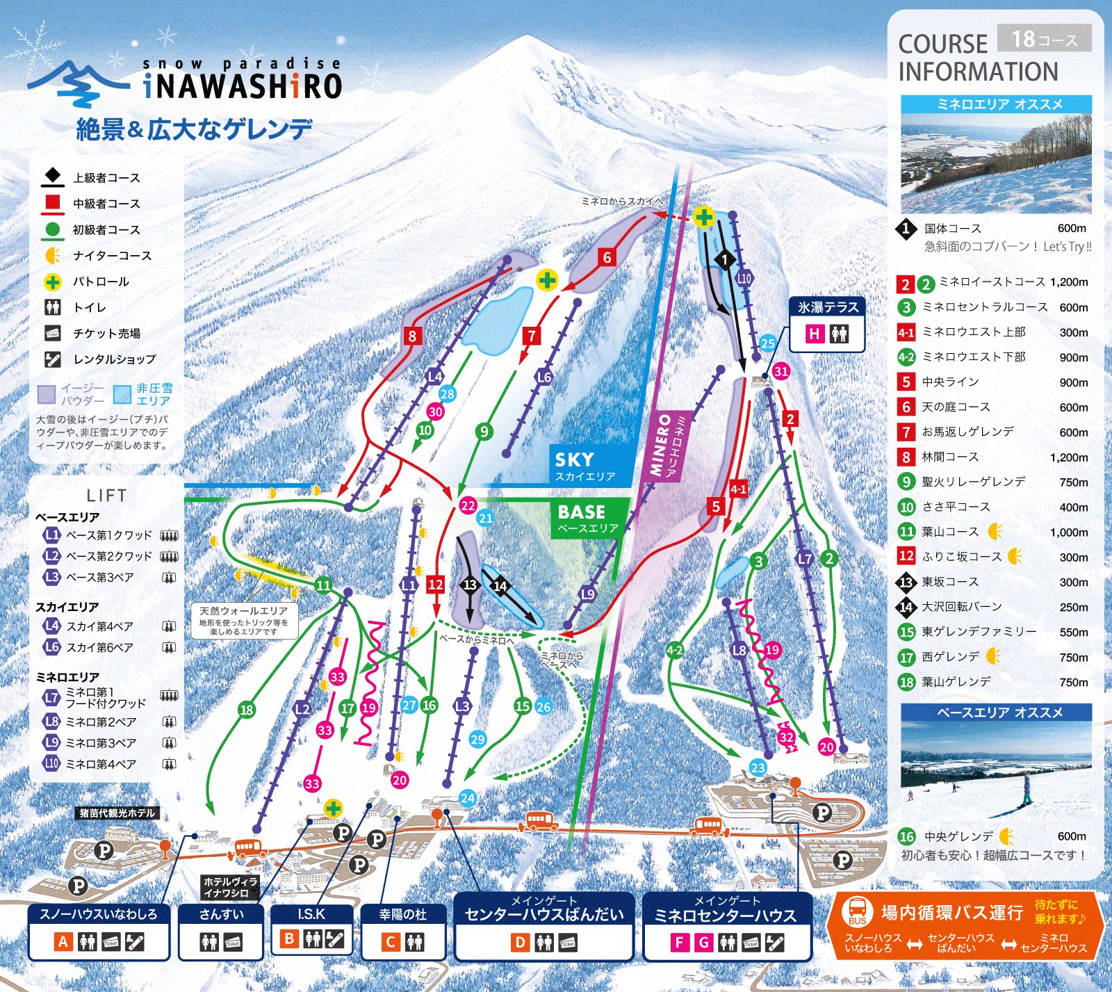 點圖看大圖Tap to enlarge
官網雪道圖(動態 GIF 的第一格)。Official gelände map (first frame of the animated GIF).
圖片來源:雪場官方Image source: official ski field · 著作權屬各雪場,本站僅縮小轉載供參考。Copyright belongs to the resort; shown reduced for reference only.
3D 雪場地圖3D map
全螢幕 / 新分頁開啟Full screen / new tab拖曳旋轉、滾輪或雙指縮放。3D 地圖為非官方,地形來自 Mapterhorn,底圖為 OpenFreeMap,可切換國土地理院空拍圖,雪道與纜車來自 OpenStreetMap,收錄在「東北 3D 雪場地圖版本庫」(3DMap-0015)。手機上有定位按鈕。Drag to rotate, scroll or pinch to zoom. Unofficial 3D map: terrain from Mapterhorn, OpenFreeMap basemap with a GSI aerial photo toggle, runs and lifts from OpenStreetMap, published in the Tohoku 3D library (3DMap-0015). On phones there is a locate button. tohoku-3d.pages.dev
出典:国土地理院(加工)・© OpenStreetMap contributors(ODbL)Source: Geospatial Information Authority of Japan (processed) · © OpenStreetMap contributors (ODbL)