Muika 滑雪度假村Muika Snow Resort

雪場資訊Resort info

Muika 以寬廣主坡與眺望南魚沼、八海山的景觀取勝,官方同時配置初學區、起伏遊戲線及上方非壓雪地形,讓練習有多種層次。少量顧客評價尤其肯定開放緩坡對家庭與基礎訓練的用途,也喜歡城市景色。其上部徒步區與申請制山岳路線並非普通新手雪道;想探索粉雪者應先理解管理界線、登記及積雪開放條件。Muika's broad main slopes look over Minamiuonuma toward Hakkaisan, giving everyday practice a distinctive setting. Official facilities include beginner areas, playful rolling features and upper ungroomed terrain. A few customers particularly appreciate the open gentle slopes for families and basic technique, alongside the town views. The upper hiking zone and application-based mountain route are a different proposition from ordinary beginner skiing. Powder-minded visitors should understand the management boundaries, registration requirements and snow-dependent opening conditions before exploring beyond the main pistes.
- 縣/地區Prefecture / area
- 新潟縣 · 南魚沼市Minamiuonuma · Niigata
- 標高/落差Elevation / vertical
- 山腳 348 m・山頂 748 m・垂直 400 mBase 348 m · top 748 m · vertical 400 m來源source
- 纜車Lifts
- 4 座4來源source
- 最長滑道Longest run
- 2.8 km來源source
- 2026-27 開放日2026-27 opening
- 2026-12-24(官方預定,至 2027-03-28)2026-12-24 (official, planned; to 28 Mar 2027)來源source
- 地形公園Terrain park
- 未整理Not compiled yet
- 票價Lift prices
大人Adult 長者Senior 兒童Child 1 日券1-day ¥5,600 — ¥2,900 2026-27 雪季 1 日券,日圓,取自 SnowJapan(整理自官網)。原文分級:Adult: 5,600 yen;Child (high school): 4,300 yen;Child (elementary): 2,900 yen。未列出的票種請以官網為準。2026-27 1-day ticket in yen, from SnowJapan (compiled from the official site). Categories as listed: Adult: 5,600 yen; Child (high school): 4,300 yen; Child (elementary): 2,900 yen.
來源source
雪道圖Trail map
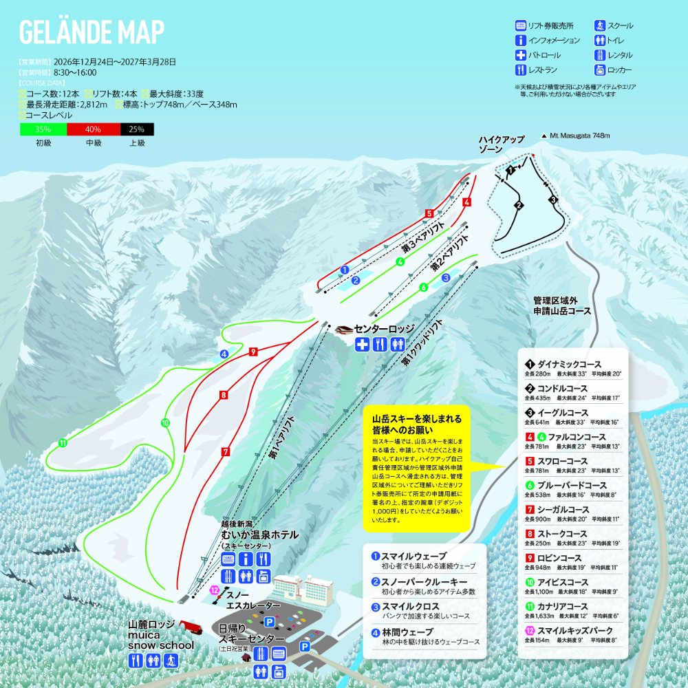 點圖看大圖Tap to enlarge
官網 2026-27 ゲレンデマップ(標示營業期間 2026-12-24~2027-03-28)。The official 2026-27 gelände map (shows the season 24 Dec 2026 – 28 Mar 2027).
圖片來源:雪場官方Image source: official ski field · 著作權屬各雪場,本站僅縮小轉載供參考。Copyright belongs to the resort; shown reduced for reference only.
3D 雪場地圖3D map
全螢幕 / 新分頁開啟Full screen / new tab拖曳旋轉、滾輪或雙指縮放。3D 地圖為非官方,地形來自 Mapterhorn,底圖為 OpenFreeMap,可切換國土地理院空拍圖,雪道與纜車來自 OpenStreetMap,收錄在「中部 3D 雪場地圖版本庫」(3DChubu-0010)。手機上有定位按鈕。Drag to rotate, scroll or pinch to zoom. Unofficial 3D map: terrain from Mapterhorn, OpenFreeMap basemap with a GSI aerial photo toggle, runs and lifts from OpenStreetMap, published in the Chubu 3D library (3DChubu-0010). On phones there is a locate button. chubu-3d.pages.dev
出典:国土地理院(加工)・© OpenStreetMap contributors(ODbL)Source: Geospatial Information Authority of Japan (processed) · © OpenStreetMap contributors (ODbL)