Chateau 鹽澤滑雪場Chateau Shiozawa
雪場資訊Resort info

Chateau 鹽澤以酒店旁的地方雪場尺度、可分區探索的雪道與南魚沼景觀見長,官方列出一本杉、吉里等不同坡面。有限顧客評價喜歡能依自己節奏滑行,也有新雪紀錄,但學校團體與濕重深雪同樣出現。它較適合不以熱門大型設施為目標、願意細看小山地形的人;「較清靜」屬個別經驗,深雪時亦需相應技術,不能因規模小就低估難度。Chateau Shiozawa offers a hotel-linked local mountain with separate slope areas and views across Minamiuonuma. Official information identifies sectors such as Ipponsugi and Yoshizato rather than presenting one uniform face. The limited customer sample enjoys skiing at a personal pace and includes fresh-snow outings, but also mentions school groups and heavy deep snow. Its appeal is exploring a less showy mountain, not an assurance of solitude. Small scale should not be confused with easy conditions when snowfall becomes deep or wet.
- 縣/地區Prefecture / area
- 新潟縣 · 南魚沼市Minamiuonuma · Niigata
- 標高/落差Elevation / vertical
- 山腳 210 m・山頂 579 m・垂直 369 mBase 210 m · top 579 m · vertical 369 m來源source
- 纜車Lifts
- 4 座4來源source
- 最長滑道Longest run
- 3 km來源source
- 2026-27 開放日2026-27 opening
- 未公布Not announced來源source
- 地形公園Terrain park
- 未整理Not compiled yet
- 票價Lift prices
大人Adult 長者Senior 兒童Child 1 日券1-day ¥4,800 ¥3,500 ¥2,500 2026-27 雪季 1 日券,日圓,取自 SnowJapan(整理自官網)。原文分級:Adult: 4,800 yen;Child (elementary school): 2,500 yen;Senior (60+): 3,500 yen。2026-27 1-day ticket in yen, from SnowJapan (compiled from the official site). Categories as listed: Adult: 4,800 yen; Child (elementary school): 2,500 yen; Senior (60+): 3,500 yen.
來源source
雪道圖Trail map
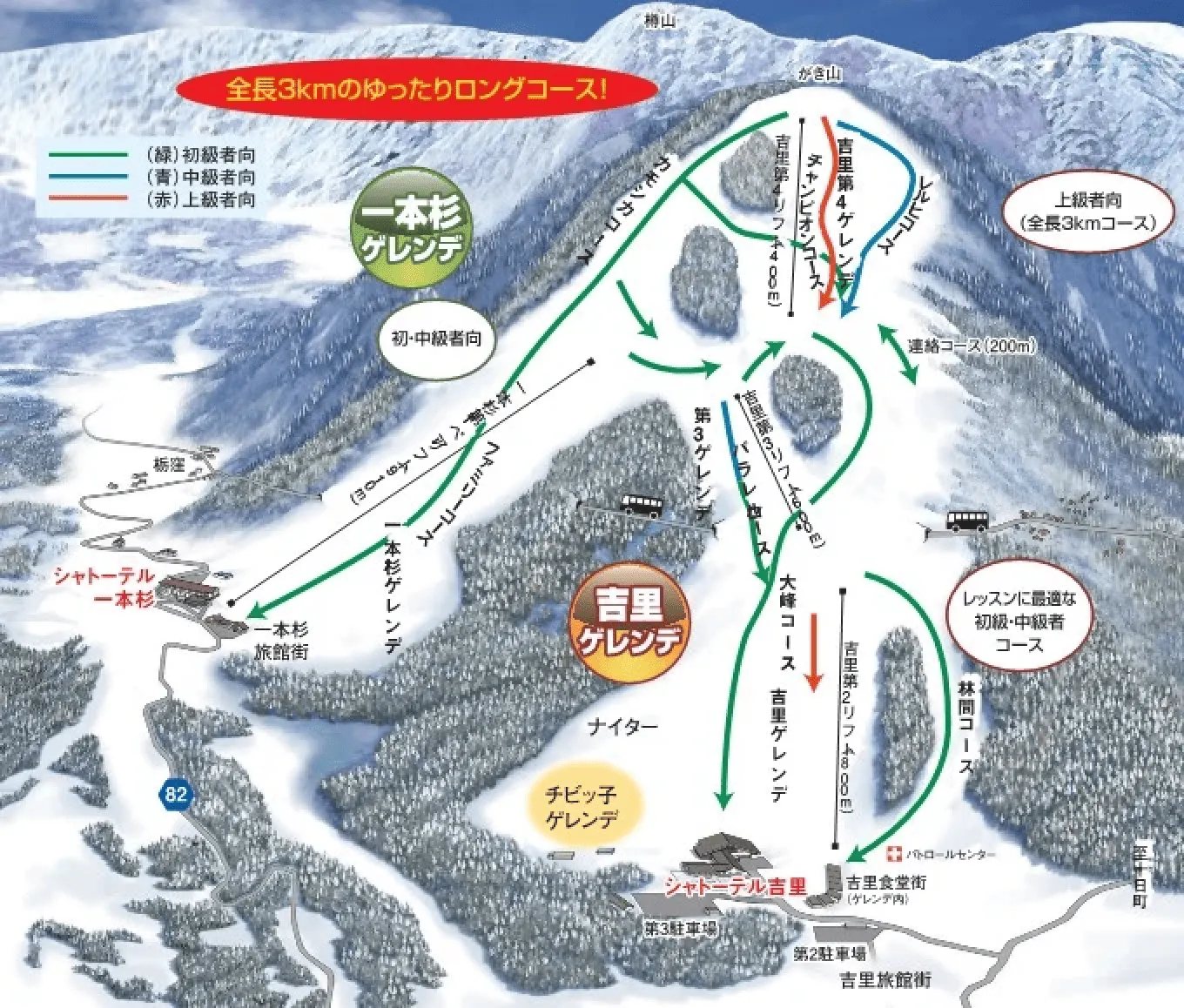 點圖看大圖Tap to enlarge
官網ゲレンデマップ(原圖為 WebP,轉成 JPEG)。Official gelände map (original WebP converted to JPEG).
圖片來源:雪場官方Image source: official ski field · 著作權屬各雪場,本站僅縮小轉載供參考。Copyright belongs to the resort; shown reduced for reference only.
3D 雪場地圖3D map
全螢幕 / 新分頁開啟Full screen / new tab拖曳旋轉、滾輪或雙指縮放。3D 地圖為非官方,地形來自 Mapterhorn,底圖為 OpenFreeMap,可切換國土地理院空拍圖,雪道與纜車來自 OpenStreetMap,收錄在「中部 3D 雪場地圖版本庫」(3DChubu-0010)。手機上有定位按鈕。Drag to rotate, scroll or pinch to zoom. Unofficial 3D map: terrain from Mapterhorn, OpenFreeMap basemap with a GSI aerial photo toggle, runs and lifts from OpenStreetMap, published in the Chubu 3D library (3DChubu-0010). On phones there is a locate button. chubu-3d.pages.dev
出典:国土地理院(加工)・© OpenStreetMap contributors(ODbL)Source: Geospatial Information Authority of Japan (processed) · © OpenStreetMap contributors (ODbL)