六日町八海山滑雪場Muikamachi Hakkaisan

雪場資訊Resort info

六日町八海山以空中纜車快速進入長落差滑行、饅頭坡與深雪地形為特色,官方定位比一般家庭緩坡雪場更偏重滑行挑戰。少量顧客評價曾享受較少人與雪道邊新雪,但也指出日照後雪面迅速改變。它適合希望長線反覆練習的有經驗滑雪者,不能把清靜個案當成固定人潮預報;與八海山麓是兩個雪場,選路、交通與票券需分開理解。Muikamachi Hakkaisan is distinguished by ropeway access to sustained vertical, moguls and deep-snow terrain. Official information presents a mountain with more technical emphasis than a simple family practice hill. A few customers enjoy quiet skiing or fresh snow at the edges, while another notes how quickly that snow changes in sunshine. It is attractive for experienced skiers seeking repeated long runs, not a guarantee of empty slopes. Keep it separate from Hakkaisan Sanroku when checking routes, access and tickets.
- 縣/地區Prefecture / area
- 新潟縣 · 南魚沼市Minamiuonuma · Niigata
- 標高/落差Elevation / vertical
- 山腳 355 m・山頂 1,175 m・垂直 820 mBase 355 m · top 1,175 m · vertical 820 m來源source
- 纜車Lifts
- 4 座4來源source
- 最長滑道Longest run
- 5.3 km來源source
- 2026-27 開放日2026-27 opening
- 2026-12-19(官方預定,至 2027-03-28)2026-12-19 (official, planned; to 28 Mar 2027)來源source
- 地形公園Terrain park
- 未整理Not compiled yet
- 票價Lift prices
大人Adult シニアSenior 兒童Child 1 日券(通常料金(12/19〜3/28))1-day (通常料金(12/19〜3/28)) ¥7,000 — — 2026-27 大人 1 日券,日圓。JAPANSNOWLINE 於 10/19 對照官網確認;長者與兒童票價未整理,請以官網為準。2026-27 adult 1-day ticket in yen, checked against the official site by JAPANSNOWLINE on 10/19. Senior and child prices not yet compiled; check the official site.
來源source
雪道圖Trail map
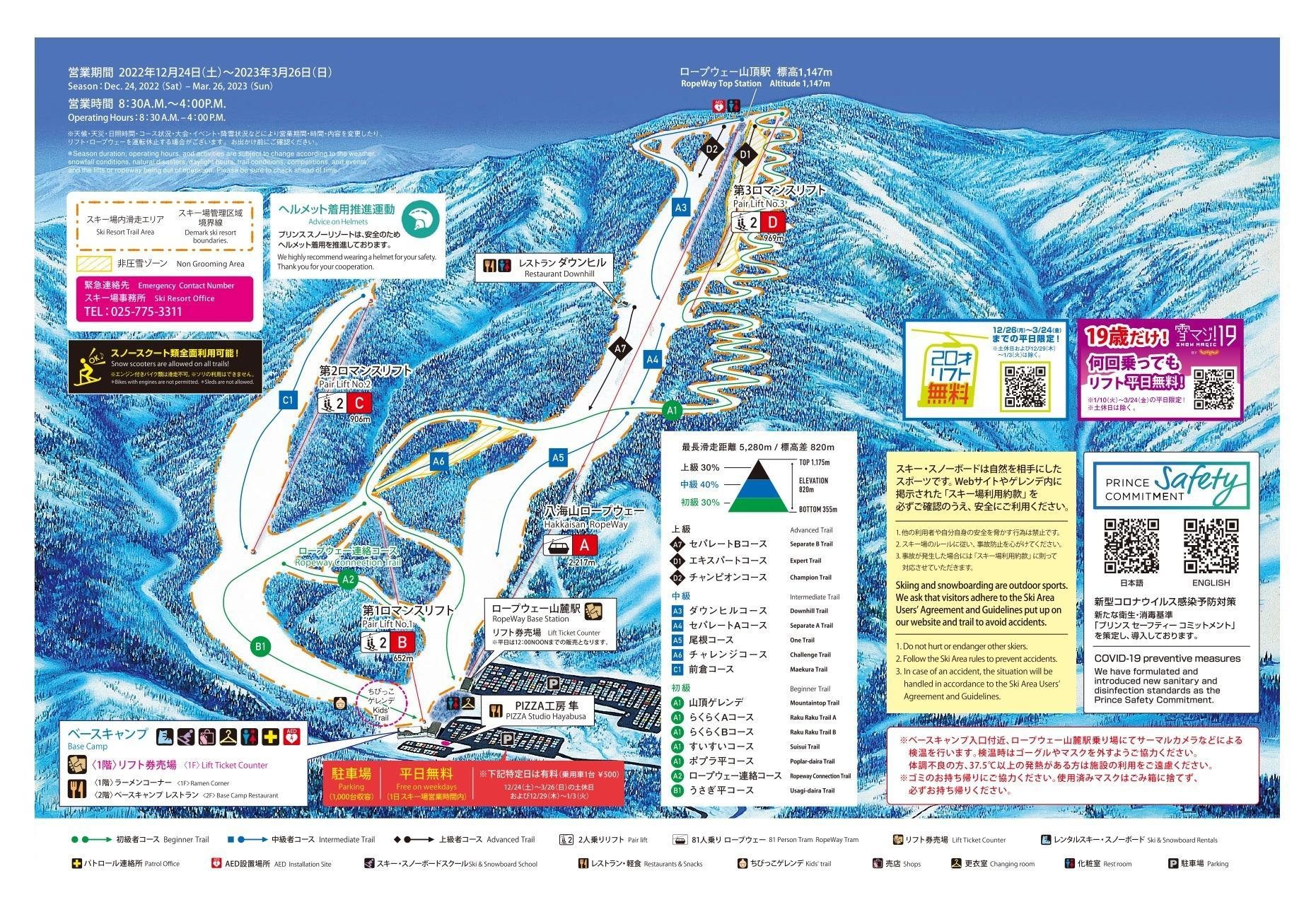 點圖看大圖Tap to enlarge
圖片來源:Snowline(snowline.jp)Image source: Snowline (snowline.jp) · 著作權屬各雪場,本站僅縮小轉載供參考。Copyright belongs to the resort; shown reduced for reference only.
3D 雪場地圖3D map
全螢幕 / 新分頁開啟Full screen / new tab拖曳旋轉、滾輪或雙指縮放。3D 地圖為非官方,地形來自 Mapterhorn,底圖為 OpenFreeMap,可切換國土地理院空拍圖,雪道與纜車來自 OpenStreetMap,收錄在「中部 3D 雪場地圖版本庫」(3DChubu-0010)。手機上有定位按鈕。Drag to rotate, scroll or pinch to zoom. Unofficial 3D map: terrain from Mapterhorn, OpenFreeMap basemap with a GSI aerial photo toggle, runs and lifts from OpenStreetMap, published in the Chubu 3D library (3DChubu-0010). On phones there is a locate button. chubu-3d.pages.dev
出典:国土地理院(加工)・© OpenStreetMap contributors(ODbL)Source: Geospatial Information Authority of Japan (processed) · © OpenStreetMap contributors (ODbL)