宮城藏王 SumikawaMiyagi Zao Sumikawa

雪場資訊Resort info

宮城藏王 Sumikawa 的特色是較高海拔的山林風景,以及滑雪、樹冰雪車行程等不同接近山岳的方式。官方強調標高與自然雪環境,少量顧客評價則欣賞高山樹木與景觀,也有人喜歡跳台;上部地形較適合已有技術者。另有訪客提醒雪路駕駛不易,因此它更適合把自然環境放在首位的行程,而非把小型雪場等同交通簡單或全山平緩。Miyagi Zao Sumikawa offers a higher-mountain atmosphere, with official information emphasising elevation, natural snow and snowcat-based experiences alongside skiing. A few visitors especially appreciate the alpine trees and scenery, while one recent log enjoys the jump features. Upper terrain is described as more suitable for competent skiers, and another review finds winter road access demanding. Its strength is the mountain environment and variety of ways to experience it, not a claim that a small resort must be easy to reach or uniformly gentle.
- 縣/地區Prefecture / area
- 宮城縣藏王町Zao · Miyagi
- 標高/落差Elevation / vertical
- 山腳 1,100 m・山頂 1,400 m・垂直 300 mBase 1,100 m · top 1,400 m · vertical 300 m來源source
- 纜車Lifts
- 3 座3來源source
- 最長滑道Longest run
- 3 km來源source
- 2026-27 開放日2026-27 opening
- 2026-12-152026-12-15來源source
- 地形公園Terrain park
- 名字有「Snow Park」但官方未見跳臺/鐵桿資訊'Snow park' is the resort name; no park features confirmed來源source
- 票價Lift prices
- 未整理Not compiled yet
雪道圖Trail map
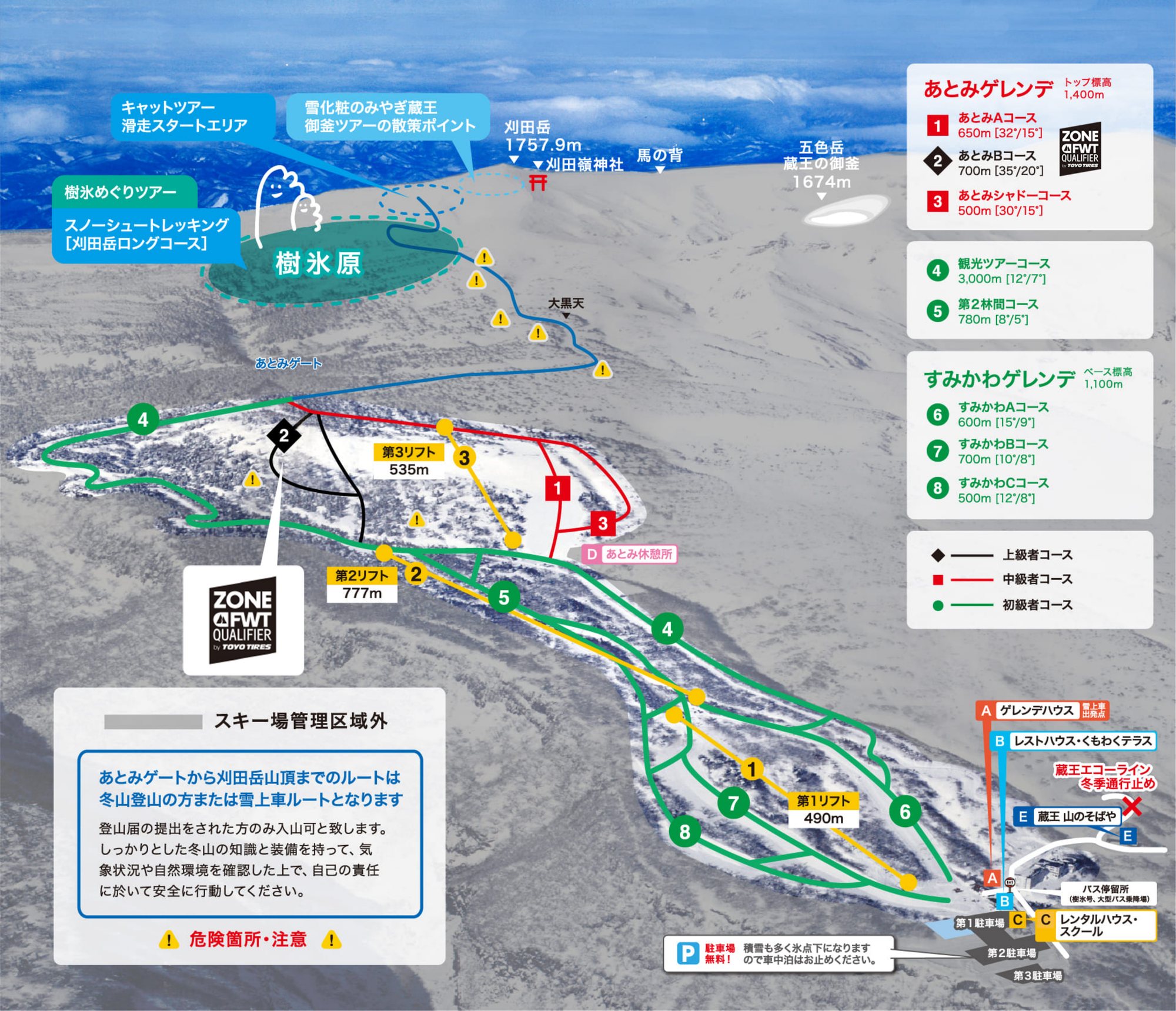 點圖看大圖Tap to enlarge
圖片來源:雪場官方Image source: official ski field · 著作權屬各雪場,本站僅縮小轉載供參考。Copyright belongs to the resort; shown reduced for reference only.
3D 雪場地圖3D map
全螢幕 / 新分頁開啟Full screen / new tab拖曳旋轉、滾輪或雙指縮放。3D 地圖為非官方,地形來自 Mapterhorn,底圖為 OpenFreeMap,可切換國土地理院空拍圖,雪道與纜車來自 OpenStreetMap,收錄在「東北 3D 雪場地圖版本庫」(3DMap-0015)。手機上有定位按鈕。Drag to rotate, scroll or pinch to zoom. Unofficial 3D map: terrain from Mapterhorn, OpenFreeMap basemap with a GSI aerial photo toggle, runs and lifts from OpenStreetMap, published in the Tohoku 3D library (3DMap-0015). On phones there is a locate button. tohoku-3d.pages.dev
出典:国土地理院(加工)・© OpenStreetMap contributors(ODbL)Source: Geospatial Information Authority of Japan (processed) · © OpenStreetMap contributors (ODbL)
附近溫泉Nearby onsen
遠刈田溫泉 神之湯Togatta Onsen Kami-no-yu
遠刈田溫泉街公共浴場Public bath in Togatta Onsen town