宮城藏王 EboshiMiyagi Zao Eboshi

雪場資訊Resort info

宮城藏王 Eboshi 把較長距離滑行與遠刈田溫泉一帶的旅遊配套結合,官方提供多種路線與不同雪上用具的區域規則。少量顧客曾在午後高處開放後享受粉雪,也有紀錄顯示纜車排隊、個別吊椅停駛會改變行程。適合希望兼顧巡航、山景與溫泉的人,但不應把過往滑行範圍照搬至新季;出發前宜確認纜車及用具限制。Miyagi Zao Eboshi combines longer cruising opportunities with the wider Togatta Onsen area. Official information includes course choices and rules distinguishing where different snow equipment may be used. A few visitors enjoy fresh snow after upper terrain opens, while other accounts mention gondola queues and an unavailable lift. It suits a trip balancing skiing, mountain scenery and a hot-spring stop, but past access should not be assumed unchanged. Check current lift operation and equipment restrictions before deciding which routes to explore.
- 縣/地區Prefecture / area
- 宮城縣藏王町Zao · Miyagi
- 標高/落差Elevation / vertical
- 山腳 650 m・山頂 1,350 m・垂直 700 mBase 650 m · top 1,350 m · vertical 700 m來源source
- 纜車Lifts
- 6 座6來源source
- 最長滑道Longest run
- 4.3 km來源source
- 2026-27 開放日2026-27 opening
- 2026-12-012026-12-01來源source
- 地形公園Terrain park
- 有:石子公園:kicker、table top、waveYes: Ishiko Park: kickers, table tops, waves來源source
- 票價Lift prices
- 未整理Not compiled yet
雪道圖Trail map
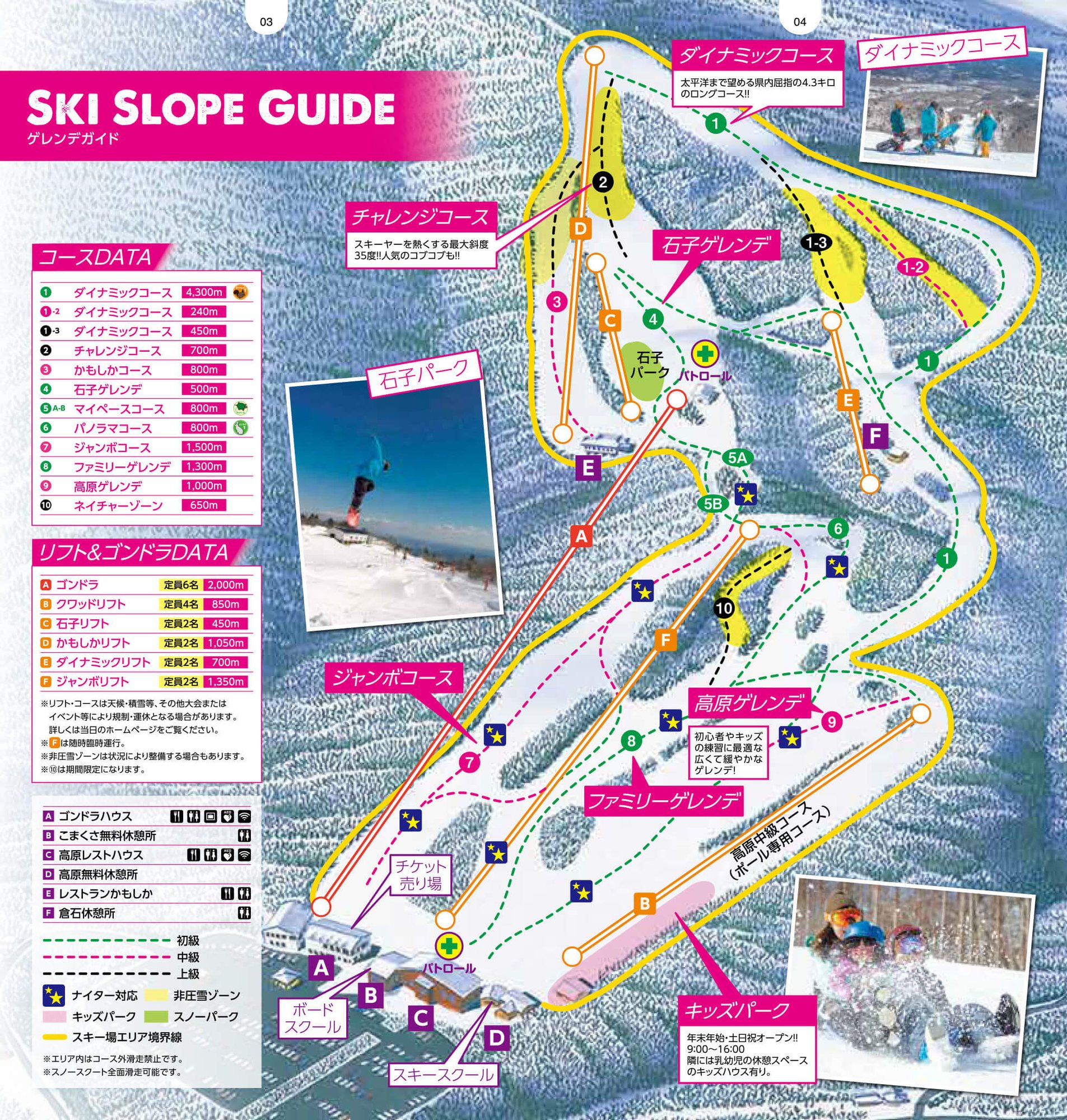 點圖看大圖Tap to enlarge
圖片來源:雪場官方Image source: official ski field · 著作權屬各雪場,本站僅縮小轉載供參考。Copyright belongs to the resort; shown reduced for reference only.
3D 雪場地圖3D map
全螢幕 / 新分頁開啟Full screen / new tab拖曳旋轉、滾輪或雙指縮放。3D 地圖為非官方,地形來自 Mapterhorn,底圖為 OpenFreeMap,可切換國土地理院空拍圖,雪道與纜車來自 OpenStreetMap,收錄在「東北 3D 雪場地圖版本庫」(3DMap-0015)。手機上有定位按鈕。Drag to rotate, scroll or pinch to zoom. Unofficial 3D map: terrain from Mapterhorn, OpenFreeMap basemap with a GSI aerial photo toggle, runs and lifts from OpenStreetMap, published in the Tohoku 3D library (3DMap-0015). On phones there is a locate button. tohoku-3d.pages.dev
出典:国土地理院(加工)・© OpenStreetMap contributors(ODbL)Source: Geospatial Information Authority of Japan (processed) · © OpenStreetMap contributors (ODbL)
附近溫泉Nearby onsen
遠刈田溫泉 壽之湯Togatta Onsen Kotobuki-no-yu
週末開放的公共浴場Weekend-only public bath