Snow Cruise ONZESnow Cruise ONZE

雪場資訊Resort info

Snow Cruise ONZE 以面向石狩灣的滑行視野及夜滑氣氛見長,適合把小樽、札幌觀光與較短的滑雪時段結合。官方雪道表包括多條初級線與較陡選擇;有限顧客評價指出,連初級雪道也能欣賞海景,這是其鮮明優點。不過早季人工造雪開放範圍可能有限,夜間或融凍後亦會出現硬雪,不能只憑海景推定容易滑。Snow Cruise ONZE offers a coastal twist on skiing near Otaru and Sapporo, with Ishikari Bay views and an established evening-skiing identity. Its official course list includes several easier routes alongside steeper options. One visitor specifically notes that the sea view is available from beginner terrain, making scenery part of the skiing rather than just a summit photo. Other accounts describe crowded early-season artificial-snow pistes and firm evening surfaces, so the attractive outlook does not guarantee easy conditions.
- 縣/地區Prefecture / area
- 北海道 · 小樽市春香町Hokkaido
- 標高/落差Elevation / vertical
- 山腳 100 m・山頂 308 m・垂直 208 mBase 100 m · top 308 m · vertical 208 m來源source
- 纜車Lifts
- 2 座2來源source
- 最長滑道Longest run
- 1 km來源source
- 2026-27 開放日2026-27 opening
- 2026 年 12 月中旬至 2027-03-28Mid-December 2026 to 28 Mar 2027來源source
- 地形公園Terrain park
- 未整理Not compiled yet
- 營業時間Hours
- 主季約 9:00–23:00Main season about 9:00–23:00來源source
- 夜間滑雪Night skiing
- 有:主季至 23:00Yes: until 23:00 in the main season來源source
- 定休日Closing days
- 未整理Not compiled yet
- 票價Lift prices
- 未整理Not compiled yet
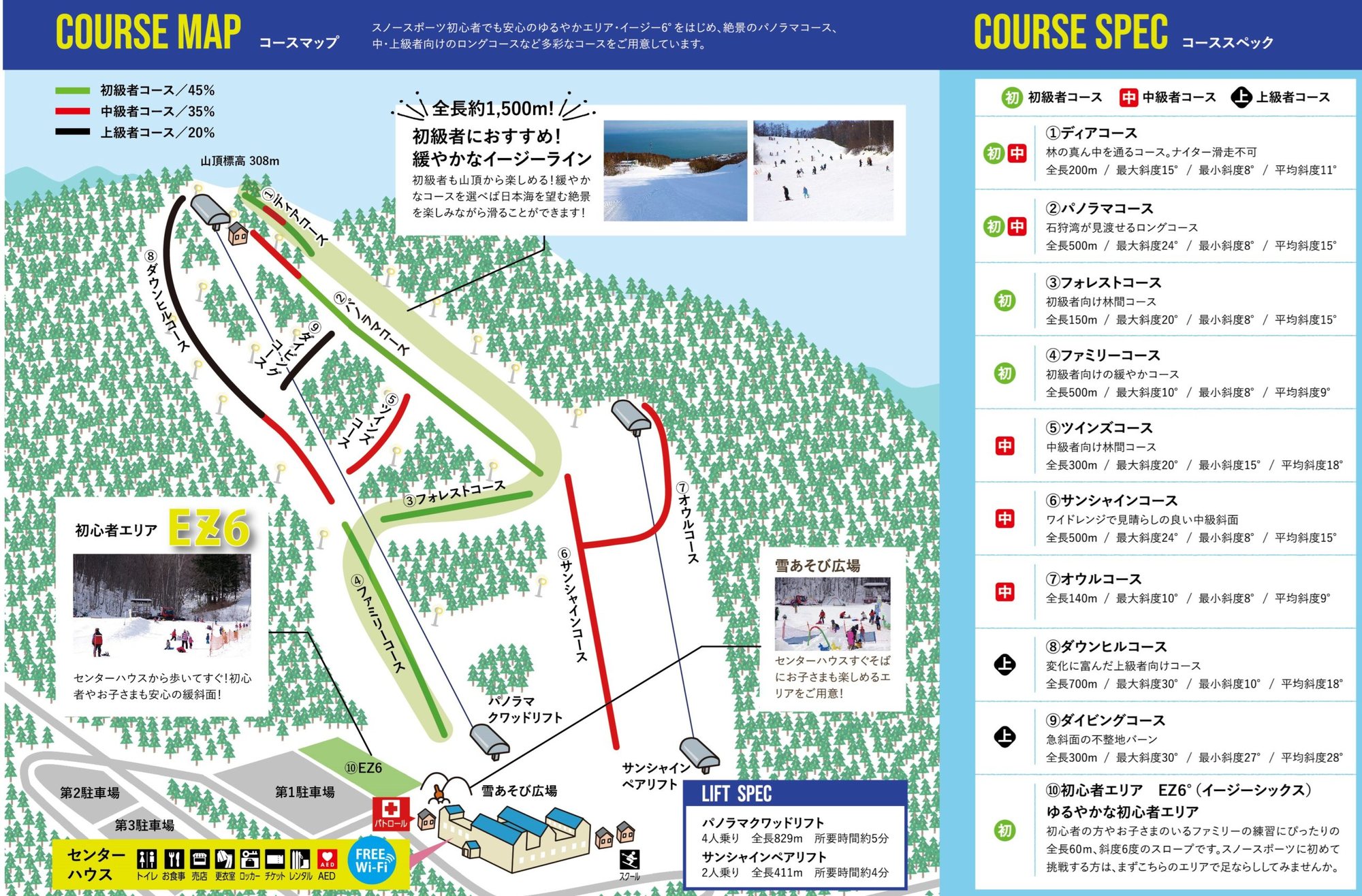
雪道圖Trail map
 點圖看大圖Tap to enlarge
官網コース頁雪道圖(2024 年上傳)。Official course-page map (uploaded 2024).
圖片來源:雪場官方Image source: official ski field · 著作權屬各雪場,本站僅縮小轉載供參考。Copyright belongs to the resort; shown reduced for reference only.
3D 雪場地圖3D map
全螢幕 / 新分頁開啟Full screen / new tab拖曳旋轉、滾輪或雙指縮放。3D 地圖為非官方,地形來自 Mapterhorn,底圖為 OpenFreeMap,可切換國土地理院空拍圖,雪道與纜車來自 OpenStreetMap,收錄在「北海道 3D 雪場地圖版本庫」(3DHokkaido-0007)。手機上有定位按鈕。Drag to rotate, scroll or pinch to zoom. Unofficial 3D map: terrain from Mapterhorn, OpenFreeMap basemap with a GSI aerial photo toggle, runs and lifts from OpenStreetMap, published in the Hokkaido 3D library (3DHokkaido-0007). On phones there is a locate button. hokkaido-3d.pages.dev
出典:国土地理院(加工)・© OpenStreetMap contributors(ODbL)Source: Geospatial Information Authority of Japan (processed) · © OpenStreetMap contributors (ODbL)