朝里川溫泉Asarigawa Onsen Ski Resort (ASARI SKI RESORT)

雪場資訊Resort info

朝里川溫泉雪場以小樽近郊的海景與溫泉地位置形成特色,官方亦提供多種吊椅、學校及租借服務,便於安排滑雪與泡湯的一日行程。可讀到的少量顧客評價多談餐飲、觀光人潮及過往吊椅故障,未足以支持「服務一致出色」的說法。因此它的亮點應放在山海景觀與地點,而非把有限評價美化;選擇雪道前宜確認當天運行。Asarigawa Onsen stands out for its coastal outlook near Otaru and its position in a hot-spring district. Official facilities include several lifts, lessons and rentals, making skiing and an onsen visit a natural combination. The limited readable customer sample is less glowing about practical details, discussing food, sightseeing traffic and a past lift breakdown. Its strongest supported selling points are setting and location, rather than uniformly excellent service; check the day's operating lifts before deciding how much terrain to expect.
- 縣/地區Prefecture / area
- 北海道 · 小樽市朝里川溫泉Hokkaido
- 標高/落差Elevation / vertical
- 山腳 140 m・山頂 680 m・垂直 540 mBase 140 m · top 680 m · vertical 540 m來源source
- 纜車Lifts
- 4 座4來源source
- 最長滑道Longest run
- 3 km來源source
- 2026-27 開放日2026-27 opening
- 2026 年 12 月上旬至 2027 年 4 月上旬Early December 2026 to early April 2027來源source
- 地形公園Terrain park
- 未整理Not compiled yet
- 營業時間Hours
- 日間約至 16:00Daytime until about 16:00來源source
- 夜間滑雪Night skiing
- 無No來源source
- 定休日Closing days
- 未整理Not compiled yet
- 票價Lift prices
- 未整理Not compiled yet
雪道圖Trail map
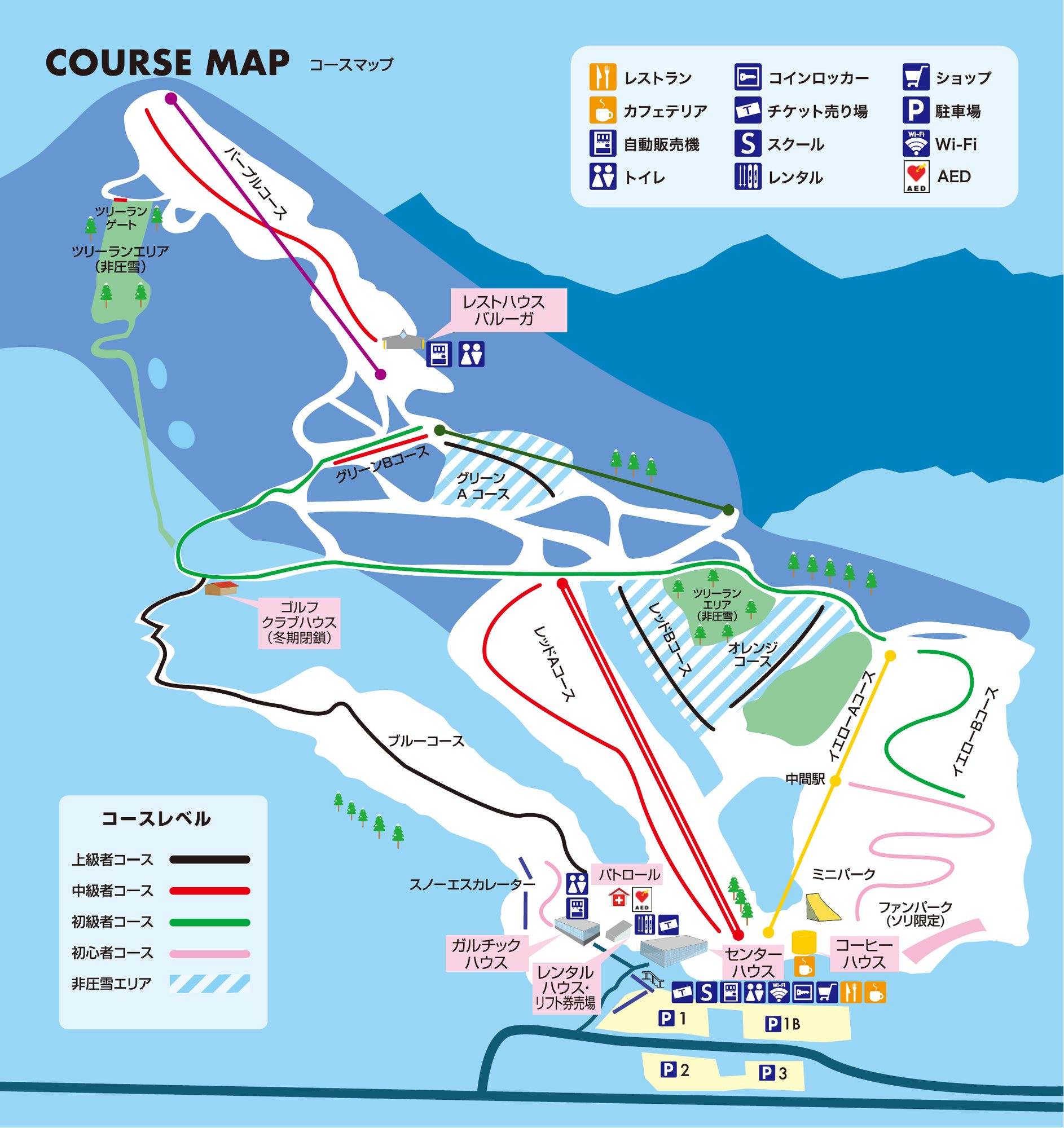 點圖看大圖Tap to enlarge
官網雪道圖 PDF 第 1 頁轉圖(另有英、韓、簡中、繁中版 PDF)。Official slope map PDF, page 1 rasterised (EN/KO/ZH PDFs also offered).
圖片來源:雪場官方Image source: official ski field · 著作權屬各雪場,本站僅縮小轉載供參考。Copyright belongs to the resort; shown reduced for reference only.
3D 雪場地圖3D map
全螢幕 / 新分頁開啟Full screen / new tab拖曳旋轉、滾輪或雙指縮放。3D 地圖為非官方,地形來自 Mapterhorn,底圖為 OpenFreeMap,可切換國土地理院空拍圖,雪道與纜車來自 OpenStreetMap,收錄在「北海道 3D 雪場地圖版本庫」(3DHokkaido-0007)。手機上有定位按鈕。Drag to rotate, scroll or pinch to zoom. Unofficial 3D map: terrain from Mapterhorn, OpenFreeMap basemap with a GSI aerial photo toggle, runs and lifts from OpenStreetMap, published in the Hokkaido 3D library (3DHokkaido-0007). On phones there is a locate button. hokkaido-3d.pages.dev
出典:国土地理院(加工)・© OpenStreetMap contributors(ODbL)Source: Geospatial Information Authority of Japan (processed) · © OpenStreetMap contributors (ODbL)