岩手高原Iwate Kogen

雪場資訊Resort info

岩手高原以具變化的山坡滑行與近郊日遊用途見長,不必靠極多雪道才有趣。官方目前主要公布新季票券資訊,雪場詳細頁仍待更新;少量顧客評價則肯定坡度轉折與西側中級路線的滑行感受,也有人喜歡餐飲配套。相同來源記錄過融雪再結冰的硬面,因此介紹其地形優勢時,不宜把冬季雪況當作不變條件,當季配置應再確認。Iwate Kogen's appeal is varied slope character rather than an exceptionally large number of pistes. The official website is currently focused on season-pass information ahead of a winter-site update. A few recent customers nevertheless describe interesting changes in gradient, enjoyable intermediate skiing on the west side and useful dining options. Another log records hard refrozen surfaces after warm weather. It is a promising regional day-ski choice, but detailed coming-season terrain arrangements and actual snow conditions need separate confirmation.
- 縣/地區Prefecture / area
- 岩手縣Iwate
- 標高/落差Elevation / vertical
- 山腳 630 m・山頂 1,213 m・垂直 583 mBase 630 m · top 1,213 m · vertical 583 m來源source
- 纜車Lifts
- 7 座7來源source
- 最長滑道Longest run
- 2.6 km來源source
- 2026-27 開放日2026-27 opening
- 2026-12-122026-12-12來源source
- 地形公園Terrain park
- 有:E4公園:kicker、jib道具,部分夜間可用Yes: E4 park: kickers and jibs, some lit at night來源source
- 票價Lift prices
- 未整理Not compiled yet
雪道圖Trail map
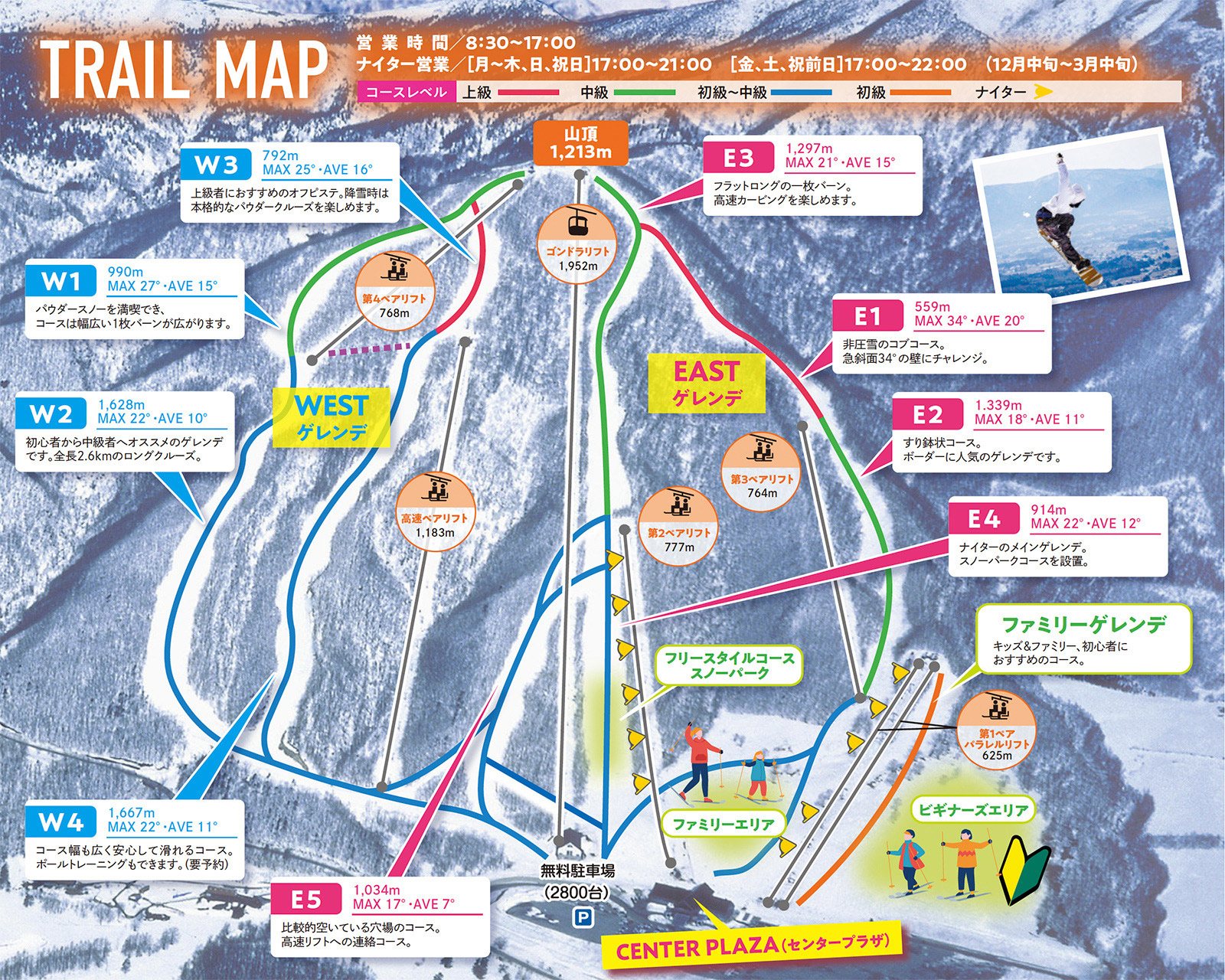 點圖看大圖Tap to enlarge
圖片來源:Snowline(snowline.jp)Image source: Snowline (snowline.jp) · 著作權屬各雪場,本站僅縮小轉載供參考。Copyright belongs to the resort; shown reduced for reference only.
3D 雪場地圖3D map
全螢幕 / 新分頁開啟Full screen / new tab拖曳旋轉、滾輪或雙指縮放。3D 地圖為非官方,地形來自 Mapterhorn,底圖為 OpenFreeMap,可切換國土地理院空拍圖,雪道與纜車來自 OpenStreetMap,收錄在「東北 3D 雪場地圖版本庫」(3DMap-0015)。手機上有定位按鈕。Drag to rotate, scroll or pinch to zoom. Unofficial 3D map: terrain from Mapterhorn, OpenFreeMap basemap with a GSI aerial photo toggle, runs and lifts from OpenStreetMap, published in the Tohoku 3D library (3DMap-0015). On phones there is a locate button. tohoku-3d.pages.dev
出典:国土地理院(加工)・© OpenStreetMap contributors(ODbL)Source: Geospatial Information Authority of Japan (processed) · © OpenStreetMap contributors (ODbL)
附近溫泉Nearby onsen
玄武溫泉 Lodge TachibanaGenbu Onsen Lodge Tachibana
雫石源泉放流小溫泉Small free-flowing onsen in Shizukuishi