網張溫泉Amihari Onsen
雪場資訊Resort info
網張溫泉把岩手山麓的森林雪道與休暇村溫泉住宿結合,官方路線兼有緩坡、中坡及較陡挑戰,適合喜歡山林氣氛的人。少量顧客分享在新雪日享受粉雪,也有人在春天利用變軟的饅頭坡練習,顯示其趣味不只一種雪況。相對地,雨天黏雪同樣見於紀錄;應按季節與技術選線,而不是把自然雪場視為全年一致的粉雪目的地。Amihari Onsen combines forested skiing beneath Mount Iwate with the accommodation and hot springs of a Kyukamura resort. Official course information includes gentle routes, intermediate skiing and steeper challenges. The limited visitor sample captures two different pleasures: fresh snow on a powder day and softer spring moguls for practice. Rain and sticky snow also appear in the accounts. Its distinctive strength is a mountain-and-onsen experience with varied skiing, rather than a single snow condition that can be expected every day.
- 縣/地區Prefecture / area
- 岩手縣 · 雫石町Shizukuishi · Iwate
- 標高/落差Elevation / vertical
- 山腳 640 m・山頂 1,350 m・垂直 710 mBase 640 m · top 1,350 m · vertical 710 m來源source
- 纜車Lifts
- 4 座4來源source
- 最長滑道Longest run
- 3 km來源source
- 2026-27 開放日2026-27 opening
- 2026-12-192026-12-19來源source
- 地形公園Terrain park
- 無專用公園,有貓跳道No dedicated park; has a mogul course來源source
- 票價Lift prices
- 未整理Not compiled yet
雪道圖Trail map
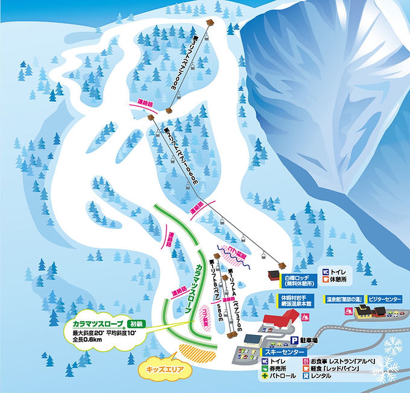 點圖看大圖Tap to enlarge
原圖解析度較低,已放大處理,細節可能略糊Low-res original, upscaled; fine detail may be soft
圖片來源:Snowline(snowline.jp)Image source: Snowline (snowline.jp) · 著作權屬各雪場,本站僅縮小轉載供參考。Copyright belongs to the resort; shown reduced for reference only.
3D 雪場地圖3D map
全螢幕 / 新分頁開啟Full screen / new tab拖曳旋轉、滾輪或雙指縮放。3D 地圖為非官方,地形來自 Mapterhorn,底圖為 OpenFreeMap,可切換國土地理院空拍圖,雪道與纜車來自 OpenStreetMap,收錄在「東北 3D 雪場地圖版本庫」(3DMap-0015)。手機上有定位按鈕。Drag to rotate, scroll or pinch to zoom. Unofficial 3D map: terrain from Mapterhorn, OpenFreeMap basemap with a GSI aerial photo toggle, runs and lifts from OpenStreetMap, published in the Tohoku 3D library (3DMap-0015). On phones there is a locate button. tohoku-3d.pages.dev
出典:国土地理院(加工)・© OpenStreetMap contributors(ODbL)Source: Geospatial Information Authority of Japan (processed) · © OpenStreetMap contributors (ODbL)
附近溫泉Nearby onsen
網張溫泉 藥師之湯Amihari Onsen Yakushi-no-yu
雪場旁乳白硫磺泉Milky sulphur bath by the slopes