藏王溫泉Zao Onsen

雪場資訊Resort info

藏王溫泉的特色是樹冰景觀、分散而廣大的雪道網絡與溫泉街,官方把滑行與冬季山岳觀賞連成完整目的地。可讀的少量近期評價並非一面倒讚美,反而提醒融凍硬雪、租借與指示問題;這有助理解名景之外的實際安排。適合願意研究路線、兼顧滑雪與泡湯的人,樹冰能否形成及高處能見度須看天候,不能只憑宣傳照片期待。Zao Onsen combines rime-covered trees, an extensive spread of ski sectors and a traditional hot-spring town. Official information makes scenery and skiing part of the same winter destination. The small readable recent review sample is notably mixed, raising refrozen surfaces, rental problems and unclear guidance rather than offering unqualified praise. It suits visitors willing to study routes and balance mountain time with the town below. Tree formation and visibility depend on weather, so iconic photographs should not be treated as a guaranteed daily experience.
- 縣/地區Prefecture / area
- 山形縣 · 山形市Yamagata
- 標高/落差Elevation / vertical
- 山腳 780 m・山頂 1,661 m・垂直 881 mBase 780 m · top 1,661 m · vertical 881 m來源source
- 纜車Lifts
- 32 座32來源source
- 最長滑道Longest run
- 10 km來源source
- 2026-27 開放日2026-27 opening
- 2026-12-12(預定,視積雪而定;官網)2026-12-12 (planned, snow permitting; official site)來源source
- 地形公園Terrain park
- 有:中森和中央區有公園Yes: Park areas in the Nakamori and Chuo areas來源source
- 營業時間Hours
- 日間纜車 8:30–17:00Daytime lifts 8:30–17:00來源source
- 夜間滑雪Night skiing
- 有:上の台區 17:00–21:00,2026-12-19 至 2027-02-28 每天,另加 3/6、3/7Yes: Uwanodai area 17:00–21:00, daily 19 Dec 2026 – 28 Feb 2027, plus 6–7 Mar來源source
- 定休日Closing days
- 未整理Not compiled yet
- 票價Lift prices
大人Adult 長者Senior 兒童Child 全山共通 1 日券(一般期)All-mountain 1 day (regular) ¥8,000 — — 全山共通 1 日券(旺季)All-mountain 1 day (peak) ¥9,000 — — 夜間券Night ¥3,000 — ¥1,500 官網 2026-27 季價格;長者與兒童日券未整理。Official 2026-27 prices; senior and child day prices not compiled.
來源source
雪道圖Trail map
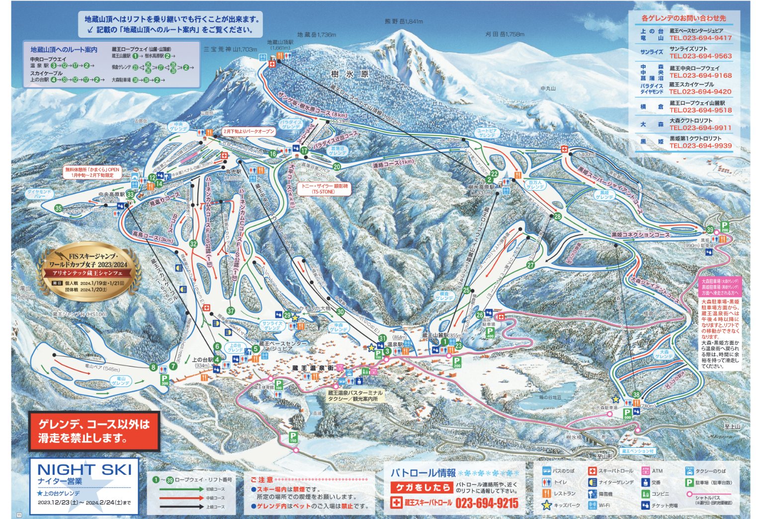 點圖看大圖Tap to enlarge
圖片來源:Snowline(snowline.jp)Image source: Snowline (snowline.jp) · 著作權屬各雪場,本站僅縮小轉載供參考。Copyright belongs to the resort; shown reduced for reference only.
3D 雪場地圖3D map
全螢幕 / 新分頁開啟Full screen / new tab拖曳旋轉、滾輪或雙指縮放。3D 地圖為非官方,地形來自 Mapterhorn,底圖為 OpenFreeMap,可切換國土地理院空拍圖,雪道與纜車來自 OpenStreetMap,收錄在「東北 3D 雪場地圖版本庫」(3DMap-0015)。手機上有定位按鈕。Drag to rotate, scroll or pinch to zoom. Unofficial 3D map: terrain from Mapterhorn, OpenFreeMap basemap with a GSI aerial photo toggle, runs and lifts from OpenStreetMap, published in the Tohoku 3D library (3DMap-0015). On phones there is a locate button. tohoku-3d.pages.dev
出典:国土地理院(加工)・© OpenStreetMap contributors(ODbL)Source: Geospatial Information Authority of Japan (processed) · © OpenStreetMap contributors (ODbL)