湯殿山Yudonosan

雪場資訊Resort info

湯殿山以多雪山區中的緊湊雪場見長,官方提供雪道、訓練與滑行設施資訊,適合喜歡反覆練習與自然地形變化的人。有限顧客文字提到雪量、跳躍地形及春季饅頭坡練習,顯示並非只有平順壓雪一種玩法。也有人遇上暖天後雪面被滑出深坑,因此其優勢是地形與雪季潛力,不應把多雪名聲解讀為任何時候都容易滑或天氣穩定。Yudonosan is a compact mountain in a snowy part of Yamagata, with official information covering its skiing and training facilities. The limited customer evidence mentions substantial snow, playful terrain features and spring mogul practice, suggesting more variety than simple groomed laps alone. Another account encounters deeply rutted surfaces during warm weather. Its appeal is the opportunity to practise and explore natural changes in terrain, not a guarantee that heavy snowfall produces easy skiing or clear weather on every visit.
- 縣/地區Prefecture / area
- 山形縣 · 鶴岡市Yamagata
- 標高/落差Elevation / vertical
- 山腳 530 m・山頂 700 m・垂直 170 mBase 530 m · top 700 m · vertical 170 m來源source
- 纜車Lifts
- 2 座2來源source
- 最長滑道Longest run
- 2 km來源source
- 2026-27 開放日2026-27 opening
- 2026-12-05(預定;鶴岡市觀光 Navi)2026-12-05 (planned; Tsuruoka tourism site)來源source
- 地形公園Terrain park
- 有:有 Snow Park,通常 1 月初起另有半管Yes: Snow Park, usually with a half pipe from early January來源source
- 營業時間Hours
- 吊椅 8:45–16:30(依日落時間調整)Lifts 8:45–16:30 (varies with sunset)來源source
- 夜間滑雪Night skiing
- 無None來源source
- 定休日Closing days
- 未整理Not compiled yet
- 票價Lift prices
大人Adult 長者Senior 兒童Child 1 日券1 day ¥4,300 — — 4 小時券4 hours ¥3,800 — — 2026-27 季調整後的大人價格(鶴岡市公告);其他票種未整理。Adult prices after the 2026-27 revision (Tsuruoka city notice); other categories not compiled.
來源source
雪道圖Trail map
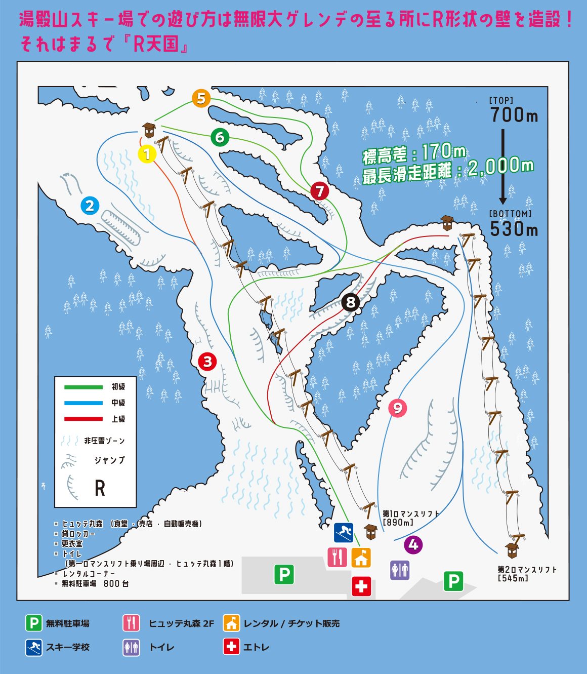 點圖看大圖Tap to enlarge
圖片來源:Snowline(snowline.jp)Image source: Snowline (snowline.jp) · 著作權屬各雪場,本站僅縮小轉載供參考。Copyright belongs to the resort; shown reduced for reference only.
3D 雪場地圖3D map
全螢幕 / 新分頁開啟Full screen / new tab拖曳旋轉、滾輪或雙指縮放。3D 地圖為非官方,地形來自 Mapterhorn,底圖為 OpenFreeMap,可切換國土地理院空拍圖,雪道與纜車來自 OpenStreetMap,收錄在「東北 3D 雪場地圖版本庫」(3DMap-0015)。手機上有定位按鈕。Drag to rotate, scroll or pinch to zoom. Unofficial 3D map: terrain from Mapterhorn, OpenFreeMap basemap with a GSI aerial photo toggle, runs and lifts from OpenStreetMap, published in the Tohoku 3D library (3DMap-0015). On phones there is a locate button. tohoku-3d.pages.dev
出典:国土地理院(加工)・© OpenStreetMap contributors(ODbL)Source: Geospatial Information Authority of Japan (processed) · © OpenStreetMap contributors (ODbL)