Asama 2000(高峰 Mountain Park)Asama 2000 (Takamine Mountain Park)

雪場資訊Resort info

高峰 Mountain Park,舊稱 Asama 2000,以約兩千公尺高原與清楚分工的雪道見長,官方介紹寬廣單面坡 DIVING、起伏巡航 CENTRAL 及獨立初學區。少量顧客特別喜歡整片坡面的刻滑與雪況,也有人認為上越天氣差時這邊可能較晴朗,但不能外推成晴天保證。適合想集中磨練轉彎的人;雪道分階段開放,開季不等於所有路線同時可滑。Takamine Mountain Park, formerly Asama 2000, combines a roughly 2,000-metre highland setting with clearly differentiated courses. Official descriptions distinguish the broad DIVING face, rolling CENTRAL cruising and a separate beginner area. A few visitors especially enjoy the carving surface and snow, while one reports clearer weather than in Joetsu on a particular trip. That is not a climate guarantee. It is appealing for concentrated technique work, with staged course openings meaning an early-season visit may offer only part of the mountain.
- 縣/地區Prefecture / area
- 長野縣 · 小諸市Komoro · Nagano
- 標高/落差Elevation / vertical
- 山腳 1,880 m・山頂 2,073 m・垂直 193 mBase 1,880 m · top 2,073 m · vertical 193 m來源source
- 纜車Lifts
- 4 座4來源source
- 最長滑道Longest run
- 900 m來源source
- 2026-27 開放日2026-27 opening
- 2026-11-212026-11-21來源source
- 地形公園Terrain park
- 未整理Not compiled yet
- 票價Lift prices
大人Adult 長者Senior 兒童Child 1 日券1-day ¥5,500 ¥4,800 ¥3,500 2026-27 雪季 1 日券,日圓,取自 SnowJapan(整理自官網)。原文分級:Adult: 5,500 yen;Child (elementary): 3,500 yen;Child (high school): 4,300 yen;Senior: 4,800 yen。2026-27 1-day ticket in yen, from SnowJapan (compiled from the official site). Categories as listed: Adult: 5,500 yen; Child (elementary): 3,500 yen; Child (high school): 4,300 yen; Senior: 4,800 yen.
來源source
雪道圖Trail map
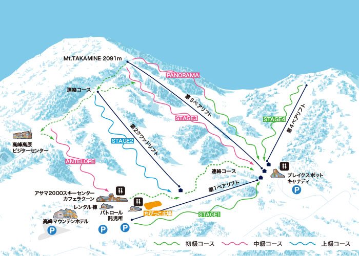 點圖看大圖Tap to enlarge
圖片來源:Snowline(snowline.jp)Image source: Snowline (snowline.jp) · 著作權屬各雪場,本站僅縮小轉載供參考。Copyright belongs to the resort; shown reduced for reference only.
3D 雪場地圖3D map
全螢幕 / 新分頁開啟Full screen / new tab拖曳旋轉、滾輪或雙指縮放。3D 地圖為非官方,地形來自 Mapterhorn,底圖為 OpenFreeMap,可切換國土地理院空拍圖,雪道與纜車來自 OpenStreetMap,收錄在「中部 3D 雪場地圖版本庫」(3DChubu-0010)。手機上有定位按鈕。Drag to rotate, scroll or pinch to zoom. Unofficial 3D map: terrain from Mapterhorn, OpenFreeMap basemap with a GSI aerial photo toggle, runs and lifts from OpenStreetMap, published in the Chubu 3D library (3DChubu-0010). On phones there is a locate button. chubu-3d.pages.dev
出典:国土地理院(加工)・© OpenStreetMap contributors(ODbL)Source: Geospatial Information Authority of Japan (processed) · © OpenStreetMap contributors (ODbL)