妙高杉之原Myoko Suginohara

雪場資訊Resort info

妙高杉之原以長距離滑行與大落差最具辨識度,官方也配置緩中坡、公園與較陡挑戰,適合希望把轉彎連成長節奏的人。少量顧客紀錄喜歡旺季雪況或較從容的滑行,但不足以代表每日人潮。另須留意新季官方已公告停車容量大幅減少並全日收費,不能沿用昔日停車便利印象;其優勢仍在山上長線,交通安排需更審慎。Myoko Suginohara is defined by long descents and substantial vertical, with official terrain also offering gentler cruising, parks and steeper challenges. It appeals to skiers who enjoy linking turns into a sustained mountain run. Limited customer accounts appreciate midwinter snow or a quieter visit, without establishing a daily crowd pattern. An important current change is the official reduction in parking capacity and introduction of paid parking on all days. The skiing remains the attraction, but arrival planning should not rely on older descriptions of plentiful parking.
- 縣/地區Prefecture / area
- 新潟縣 · 妙高市Myoko · Niigata
- 標高/落差Elevation / vertical
- 山腳 731 m・山頂 1,855 m・垂直 1,124 mBase 731 m · top 1,855 m · vertical 1,124 m來源source
- 纜車Lifts
- 5 座5來源source
- 最長滑道Longest run
- 8.5 km來源source
- 2026-27 開放日2026-27 opening
- 2026-12-192026-12-19來源source
- 地形公園Terrain park
- 有:Sugi Park 1st、2nd、3rd。Yes: Sugi Park 1st, 2nd and 3rd.來源source
- 票價Lift prices
大人Adult 長者Senior 兒童Child 1 日券1-day ¥9,000 ¥8,400 — 2026-27 雪季 1 日券,日圓,取自 SnowJapan(整理自官網)。原文分級:Adult: 9,000 yen;Child (high school): 8,400 yen;Senior (55+): 8,400 yen。未列出的票種請以官網為準。2026-27 1-day ticket in yen, from SnowJapan (compiled from the official site). Categories as listed: Adult: 9,000 yen; Child (high school): 8,400 yen; Senior (55+): 8,400 yen.
來源source
雪道圖Trail map
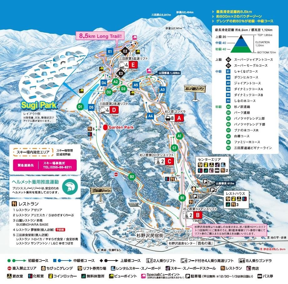 點圖看大圖Tap to enlarge
圖片來源:Snowline(snowline.jp)Image source: Snowline (snowline.jp) · 著作權屬各雪場,本站僅縮小轉載供參考。Copyright belongs to the resort; shown reduced for reference only.
3D 雪場地圖3D map
全螢幕 / 新分頁開啟Full screen / new tab拖曳旋轉、滾輪或雙指縮放。3D 地圖為非官方,地形來自 Mapterhorn,底圖為 OpenFreeMap,可切換國土地理院空拍圖,雪道與纜車來自 OpenStreetMap,收錄在「中部 3D 雪場地圖版本庫」(3DChubu-0010)。手機上有定位按鈕。Drag to rotate, scroll or pinch to zoom. Unofficial 3D map: terrain from Mapterhorn, OpenFreeMap basemap with a GSI aerial photo toggle, runs and lifts from OpenStreetMap, published in the Chubu 3D library (3DChubu-0010). On phones there is a locate button. chubu-3d.pages.dev
出典:国土地理院(加工)・© OpenStreetMap contributors(ODbL)Source: Geospatial Information Authority of Japan (processed) · © OpenStreetMap contributors (ODbL)