菅平高原Sugadaira Kogen
雪場資訊Resort info

菅平高原以多區雪道與濃厚訓練、競賽氣氛見長,官方把 Pine Beak、太郎與 Davos 等區域清楚列出,適合目的明確的技術練習。有限顧客評價也反覆提到賽事、旗門及包場限制,顯示這既是特色,也是一般客需規劃的條件。它不只是追逐粉雪的目的地;想自由巡航者應先查看雪道管制與停車安排,避免把龐大名目雪道數當成全部可用。Sugadaira Kogen's identity is its extensive multi-sector terrain and strong training-and-racing culture. Official information distinguishes Pine Beak, Taro and Davos, supporting purposeful technique sessions rather than powder chasing alone. The limited customer sample repeatedly mentions competitions, gate lanes and reserved slopes. Those are both part of its character and a practical constraint for recreational visitors. Check course restrictions and parking before choosing a base, because a large advertised network does not mean every piste is freely available on a competition day.
- 縣/地區Prefecture / area
- 長野縣 · 上田市Ueda · Nagano
- 標高/落差Elevation / vertical
- 山腳 1,250 m・山頂 1,650 m・垂直 400 mBase 1,250 m · top 1,650 m · vertical 400 m來源source
- 纜車Lifts
- 19 座19來源source
- 最長滑道Longest run
- 2.2 km來源source
- 2026-27 開放日2026-27 opening
- 11/28 開放(預定,視降雪而定)Opens 11/28 (planned, snow permitting)來源source
- 地形公園Terrain park
- 有:各區設有多處雪地公園;Davos 區另有雪貓之旅。Yes: Various park areas across the slopes; cat tours in the Davos area.來源source
- 票價Lift prices
- 未整理Not compiled yet
雪道圖Trail map
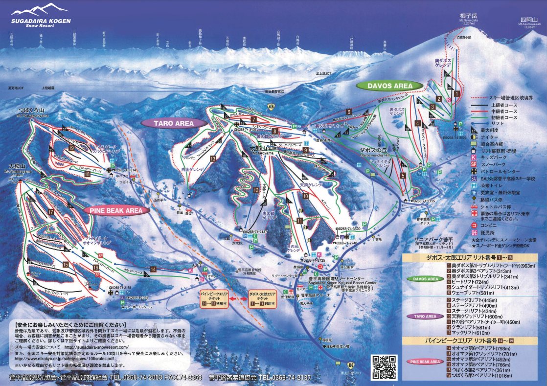 點圖看大圖Tap to enlarge
圖片來源:Snowline(snowline.jp)Image source: Snowline (snowline.jp) · 著作權屬各雪場,本站僅縮小轉載供參考。Copyright belongs to the resort; shown reduced for reference only.
3D 雪場地圖3D map
全螢幕 / 新分頁開啟Full screen / new tab拖曳旋轉、滾輪或雙指縮放。3D 地圖為非官方,地形來自 Mapterhorn,底圖為 OpenFreeMap,可切換國土地理院空拍圖,雪道與纜車來自 OpenStreetMap,收錄在「中部 3D 雪場地圖版本庫」(3DChubu-0010)。手機上有定位按鈕。Drag to rotate, scroll or pinch to zoom. Unofficial 3D map: terrain from Mapterhorn, OpenFreeMap basemap with a GSI aerial photo toggle, runs and lifts from OpenStreetMap, published in the Chubu 3D library (3DChubu-0010). On phones there is a locate button. chubu-3d.pages.dev
出典:国土地理院(加工)・© OpenStreetMap contributors(ODbL)Source: Geospatial Information Authority of Japan (processed) · © OpenStreetMap contributors (ODbL)