龍王滑雪公園Ryuoo Ski Park

雪場資訊Resort info

龍王滑雪公園以高低山區反差最具特色:官方介紹寬平主坡、高處緩坡,以及要求技術與裝備的木落 Bowl,並有 SORA terrace 山景。少量顧客評價喜歡公園練習與地形起伏,也提醒學生假期人潮及春季上下雪質差異。它能同時吸引新手與進階者,但不能把高處緩坡等同可輕鬆滑下全山;公園配置已公告新季變更,須查新版地圖。Ryuoo Ski Park's defining feature is contrast: broad lower slopes and gentle upper terrain sit alongside the demanding Kiotoshi Bowl, with SORA terrace adding a scenic dimension. Official guidance distinguishes those experiences and their equipment requirements. A few customers enjoy park practice and rolling terrain but also mention student-holiday crowds and different spring conditions above and below. Beginners should not assume that easy upper slopes imply an easy continuous descent. The park layout is changing for the coming season, making a current map essential.
- 縣/地區Prefecture / area
- 長野縣 · 山之內町Yamanouchi · Nagano
- 標高/落差Elevation / vertical
- 山腳 850 m・山頂 1,930 m・垂直 1,080 mBase 850 m · top 1,930 m · vertical 1,080 m來源source
- 纜車Lifts
- 8 座8來源source
- 最長滑道Longest run
- 6 km來源source
- 2026-27 開放日2026-27 opening
- 2026-12-05(官方預定)2026-12-05 (official, planned)來源source
- 地形公園Terrain park
- 有:有:Blue & Green park、Wavy LinesYes: Yes: Blue & Green park and Wavy Lines來源source
- 票價Lift prices
大人Adult 長者Senior 兒童Child 一般期 1 日券(週末假日)Regular 1-day (weekend/holiday) ¥6,200 — ¥3,200 一般期 1 日券(平日)Regular 1-day (weekday) ¥6,000 — ¥3,000 官網票價,日圓;一般期 2026/12/19–2027/3/22。大人為國中以上,兒童為 4 歲以上;長者價未列。另需 IC 卡押金 ¥500。Official prices in yen; regular period 19 Dec 2026–22 Mar 2027. Adult = junior high+, child = 4+; no senior price listed. ¥500 IC card deposit.
來源source
雪道圖Trail map
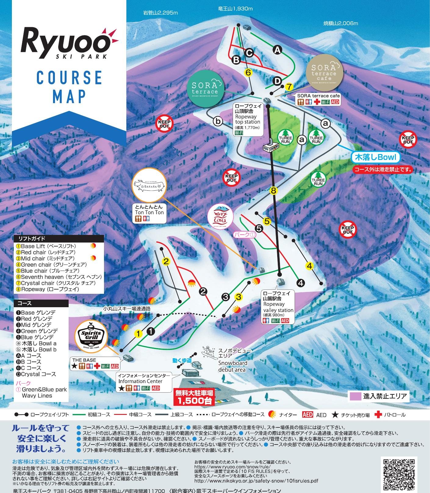 點圖看大圖Tap to enlarge
官方 PDF 第 1 頁(裁掉下方宣傳圖)轉成圖片。Page 1 of the official PDF (promo banner cropped off) converted to an image.
圖片來源:雪場官方Image source: official ski field · 著作權屬各雪場,本站僅縮小轉載供參考。Copyright belongs to the resort; shown reduced for reference only.
3D 雪場地圖3D map
全螢幕 / 新分頁開啟Full screen / new tab拖曳旋轉、滾輪或雙指縮放。3D 地圖為非官方,地形來自 Mapterhorn,底圖為 OpenFreeMap,可切換國土地理院空拍圖,雪道與纜車來自 OpenStreetMap,收錄在「中部 3D 雪場地圖版本庫」(3DChubu-0010)。手機上有定位按鈕。Drag to rotate, scroll or pinch to zoom. Unofficial 3D map: terrain from Mapterhorn, OpenFreeMap basemap with a GSI aerial photo toggle, runs and lifts from OpenStreetMap, published in the Chubu 3D library (3DChubu-0010). On phones there is a locate button. chubu-3d.pages.dev
出典:国土地理院(加工)・© OpenStreetMap contributors(ODbL)Source: Geospatial Information Authority of Japan (processed) · © OpenStreetMap contributors (ODbL)