比布 PippuPippu

雪場資訊Resort info
比布 Pippu 的優勢是面向上川盆地的開闊視野,以及可讓不同程度滑雪者選擇的多樣雪道。官方以大雪山連峰為背景介紹其地形;少量顧客評價尤其喜歡整理良好的中坡,也有人認為規模與滑行長度比預期充實。相較觀光型大型度假村,這裡更適合安排踏實的練習日;但學校活動、人潮與融凍後的硬雪仍會改變當天感受。Pippu pairs open views across the Kamikawa basin with a varied local mountain backed by the Daisetsuzan range. Official information presents courses for different ability levels, while the small review sample particularly values its groomed intermediate slopes. One visitor found more length and variety than expected; another appreciated a quiet day. This makes it an appealing practice-oriented stop rather than a resort built around nightlife, with school groups and freeze-thaw conditions still capable of changing the experience.
- 縣/地區Prefecture / area
- 北海道 · 上川郡比布町Hokkaido
- 標高/落差Elevation / vertical
- 山腳 250 m・山頂 580 m・垂直 330 mBase 250 m · top 580 m · vertical 330 m來源source
- 纜車Lifts
- 4 座4來源source
- 最長滑道Longest run
- 2.2 km來源source
- 2026-27 開放日2026-27 opening
- 2026 年 12 月中旬至 2027-03-22(預定)Mid-December 2026 to 22 Mar 2027 (planned)來源source
- 地形公園Terrain park
- 有:Snow Park 在上段第 2 初級雪道旁Yes: Snow Park on the upper area by the No. 2 beginner course來源source
- 營業時間Hours
- 日間每天 9:00–16:00(12/31 至 16:00,1/1 10:00 起)Daytime 9:00–16:00 daily (31 Dec until 16:00; 1 Jan from 10:00)來源source
- 夜間滑雪Night skiing
- 有:16:00–20:30,到 2 月底Yes: 16:00–20:30 until the end of February來源source
- 定休日Closing days
- 無定休日(白天每天營業;SnowJapan)No regular closing days (open every day in the daytime; SnowJapan)
- 票價Lift prices
大人Adult 長者Senior 兒童Child 1 日券1 day ¥3,800 — ¥2,800 4 小時券4 hours ¥3,000 — ¥2,300 SnowJapan 2026-27 季價格;年齡分級依雪場規定,部分雪場另有高中生等票種,請以官網為準。SnowJapan 2026-27 prices. Age bands follow each resort; some resorts have extra categories such as high-school tickets. Check the official site.
來源source
雪道圖Trail map
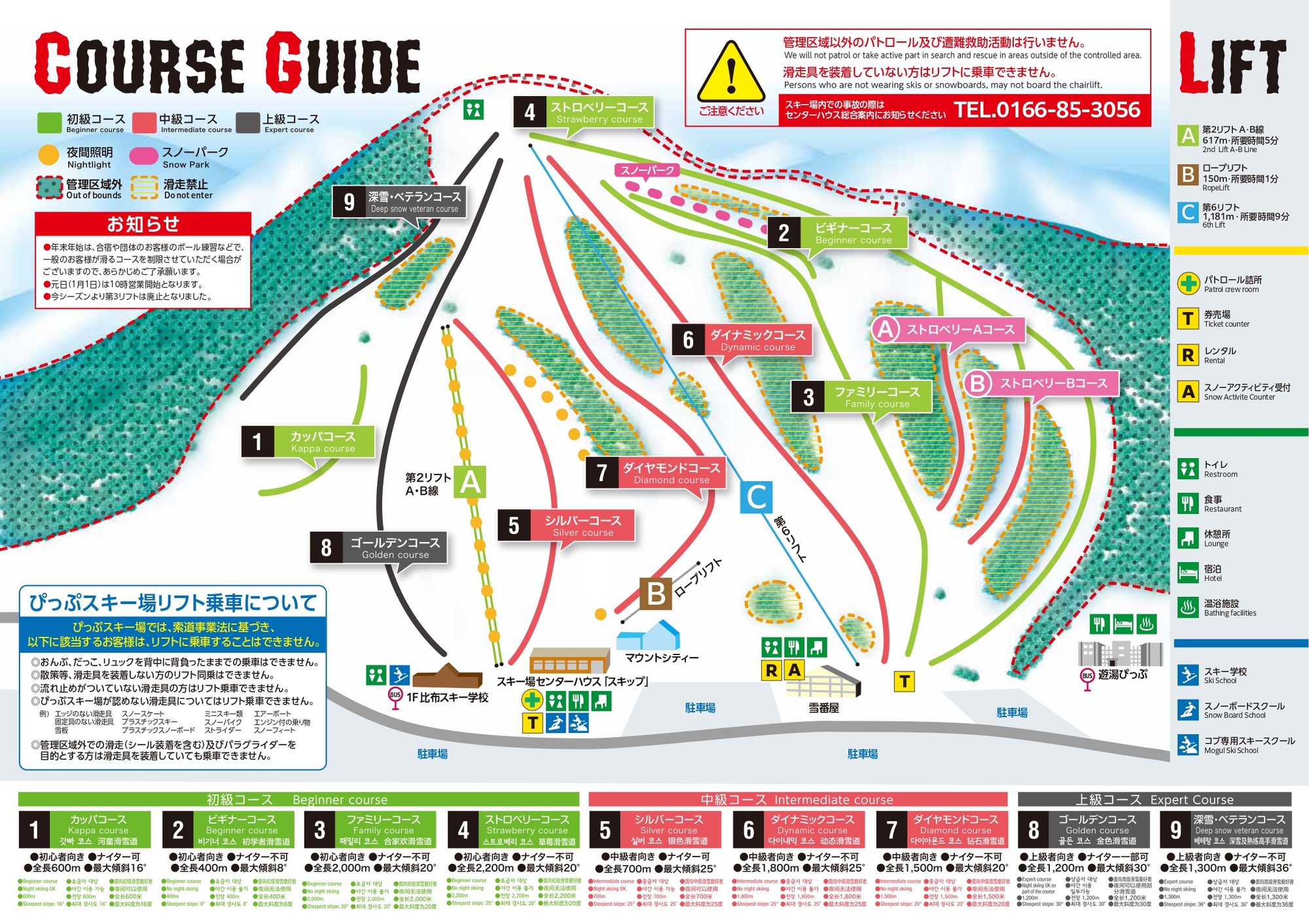 點圖看大圖Tap to enlarge
圖片來源:Snowline(snowline.jp)Image source: Snowline (snowline.jp) · 著作權屬各雪場,本站僅縮小轉載供參考。Copyright belongs to the resort; shown reduced for reference only.
3D 雪場地圖3D map
全螢幕 / 新分頁開啟Full screen / new tab拖曳旋轉、滾輪或雙指縮放。3D 地圖為非官方,地形來自 Mapterhorn,底圖為 OpenFreeMap,可切換國土地理院空拍圖,雪道與纜車來自 OpenStreetMap,收錄在「北海道 3D 雪場地圖版本庫」(3DHokkaido-0007)。手機上有定位按鈕。Drag to rotate, scroll or pinch to zoom. Unofficial 3D map: terrain from Mapterhorn, OpenFreeMap basemap with a GSI aerial photo toggle, runs and lifts from OpenStreetMap, published in the Hokkaido 3D library (3DHokkaido-0007). On phones there is a locate button. hokkaido-3d.pages.dev
出典:国土地理院(加工)・© OpenStreetMap contributors(ODbL)Source: Geospatial Information Authority of Japan (processed) · © OpenStreetMap contributors (ODbL)