野澤溫泉Nozawa Onsen

雪場資訊Resort info

野澤溫泉的特色是高處山林雪區、長距離稜線滑行與山腳溫泉村,官方雪道指南清楚區分 Yamabiko、Skyline 及親子緩坡等不同體驗。有限顧客評價尤其喜歡高處雪面與全山多樣性,也有人認為大範圍能分散人流。這不是保證無須排隊;長線部分路段較窄,回村路線亦有難度差異,適合願意研究地圖、兼顧滑行與地方生活的人。Nozawa Onsen pairs upper-mountain forest skiing and long ridge runs with a hot-spring village below. Official descriptions distinguish the Yamabiko sector, Skyline and gentler family slopes, giving different ability levels genuinely different experiences. A few visitors particularly enjoy the upper snow and breadth of choice, and one feels the terrain helps spread people out. That is not a queue-free guarantee. Narrow sections and differing descent difficulties make route planning important, especially for groups combining village time with a full mountain day.
- 縣/地區Prefecture / area
- 長野縣 · 下高井郡野沢溫泉村Nagano
- 標高/落差Elevation / vertical
- 山腳 565 m・山頂 1,650 m・垂直 1,085 mBase 565 m · top 1,650 m · vertical 1,085 m來源source
- 纜車Lifts
- 17 座17來源source
- 最長滑道Longest run
- 10 km來源source
- 2026-27 開放日2026-27 opening
- 2026-11-28 至 2027-05-05(官網)2026-11-28 to 2027-05-05 (official site)來源source
- 地形公園Terrain park
- 有:上之平 Snow Park(標高 1,220–1,410 m,全長約 2 km),12 月下旬至季末Yes: Uenotaira Snow Park (1,220–1,410 m, about 2 km), late December to season end來源source
- 營業時間Hours
- 日間 8:30–16:30;3/29–5/5 為 8:10–15:30Daytime 8:30–16:30; 8:10–15:30 from 29 Mar to 5 May來源source
- 夜間滑雪Night skiing
- 有:長坂四人吊椅 16:30–20:00,2026-12-26 至 2027-01-02 每天,以及 1/9 至 3/20 的每週六(另加 1/10、3/21)Yes: Nagasaka quad 16:30–20:00, daily 26 Dec 2026 – 2 Jan 2027 and Saturdays 9 Jan – 20 Mar (plus 10 Jan and 21 Mar)來源source
- 定休日Closing days
- 季中無休Open every day of the season
- 票價Lift prices
大人Adult 長者Senior 兒童Child 1 日券1 day ¥7,800 ¥6,300 ¥4,700 2 日券2 days ¥14,500 ¥11,650 ¥8,700 SnowJapan 2026-27 季價格;年齡分級依雪場規定,部分雪場另有高中生等票種,請以官網為準。SnowJapan 2026-27 prices. Age bands follow each resort; some resorts have extra categories such as high-school tickets. Check the official site.
來源source
雪道圖Trail map
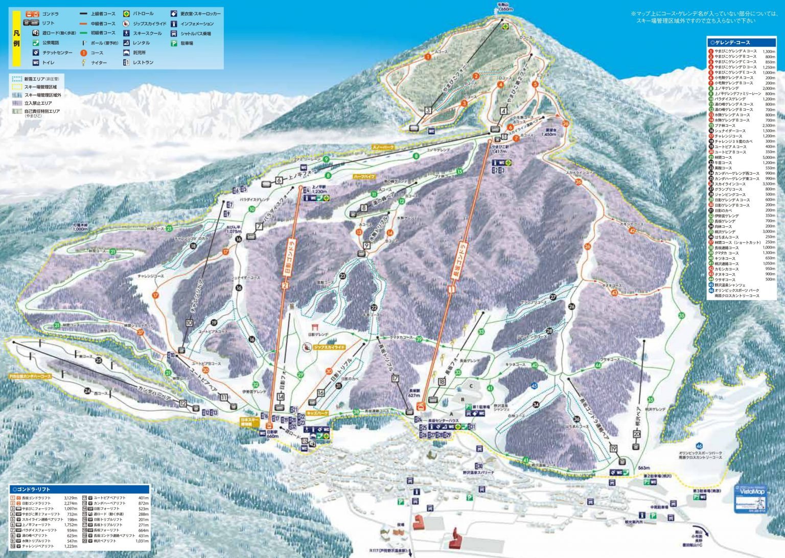 點圖看大圖Tap to enlarge
圖片來源:Snowline(snowline.jp)Image source: Snowline (snowline.jp) · 著作權屬各雪場,本站僅縮小轉載供參考。Copyright belongs to the resort; shown reduced for reference only.
3D 雪場地圖3D map
全螢幕 / 新分頁開啟Full screen / new tab拖曳旋轉、滾輪或雙指縮放。3D 地圖為非官方,地形來自 Mapterhorn,底圖為 OpenFreeMap,可切換國土地理院空拍圖,雪道與纜車來自 OpenStreetMap,收錄在「中部 3D 雪場地圖版本庫」(3DChubu-0010)。手機上有定位按鈕。Drag to rotate, scroll or pinch to zoom. Unofficial 3D map: terrain from Mapterhorn, OpenFreeMap basemap with a GSI aerial photo toggle, runs and lifts from OpenStreetMap, published in the Chubu 3D library (3DChubu-0010). On phones there is a locate button. chubu-3d.pages.dev
出典:国土地理院(加工)・© OpenStreetMap contributors(ODbL)Source: Geospatial Information Authority of Japan (processed) · © OpenStreetMap contributors (ODbL)