湯澤中里滑雪度假村Yuzawa Nakazato

雪場資訊Resort info

湯澤中里的鮮明定位是家庭與初學者,官方設計緩坡、輸送帶及起伏遊戲線,讓練習不只重複直滑,同時也有陡坡與樹林地形。少量顧客紀錄顯示新雪日能享受粉雪,但也提醒過平路段在濕雪時容易停住,反而增加新手負擔。它的優點是循序學習與親子配套,而不是全山都容易;進階區須依程度及開放規則選擇。Yuzawa Nakazato has a clear family-and-beginner identity, with official gentle slopes, conveyors and playful rolling features that make progression more engaging. Steeper terrain and tree areas provide a different challenge beyond that introductory offering. A few customers enjoy fresh snow, but another points out that very flat sections become difficult when wet snow stops the skis or board. Its strength is structured progression and family facilities, not uniformly easy skiing. Choose advanced areas according to ability and the current access rules.
- 縣/地區Prefecture / area
- 新潟縣 · 湯澤町Yuzawa · Niigata
- 標高/落差Elevation / vertical
- 山腳 458 m・山頂 702 m・垂直 244 mBase 458 m · top 702 m · vertical 244 m來源source
- 纜車Lifts
- 7 座7來源source
- 最長滑道Longest run
- 2 km來源source
- 2026-27 開放日2026-27 opening
- 未公布Not announced來源source
- 地形公園Terrain park
- 有:非壓雪區(FWT ZONE)旁設有地形公園「Growth Park」。Yes: Terrain park "Growth Park" alongside the FWT Zone.來源source
- 票價Lift prices
大人Adult 長者Senior 兒童Child 1 日券1-day ¥6,700 — ¥3,400 2026-27 雪季 1 日券,日圓,取自 SnowJapan(整理自官網)。原文分級:Adult: 6,700 yen;Elementary school: 3,400 yen。未列出的票種請以官網為準。2026-27 1-day ticket in yen, from SnowJapan (compiled from the official site). Categories as listed: Adult: 6,700 yen; Elementary school: 3,400 yen.
來源source
雪道圖Trail map
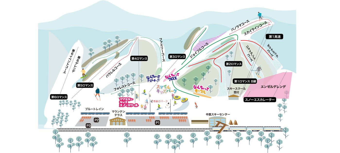 點圖看大圖Tap to enlarge
圖片來源:Snowline(snowline.jp)Image source: Snowline (snowline.jp) · 著作權屬各雪場,本站僅縮小轉載供參考。Copyright belongs to the resort; shown reduced for reference only.
3D 雪場地圖3D map
全螢幕 / 新分頁開啟Full screen / new tab拖曳旋轉、滾輪或雙指縮放。3D 地圖為非官方,地形來自 Mapterhorn,底圖為 OpenFreeMap,可切換國土地理院空拍圖,雪道與纜車來自 OpenStreetMap,收錄在「中部 3D 雪場地圖版本庫」(3DChubu-0010)。手機上有定位按鈕。Drag to rotate, scroll or pinch to zoom. Unofficial 3D map: terrain from Mapterhorn, OpenFreeMap basemap with a GSI aerial photo toggle, runs and lifts from OpenStreetMap, published in the Chubu 3D library (3DChubu-0010). On phones there is a locate button. chubu-3d.pages.dev
出典:国土地理院(加工)・© OpenStreetMap contributors(ODbL)Source: Geospatial Information Authority of Japan (processed) · © OpenStreetMap contributors (ODbL)