鹿澤Kazawa Snow Area
雪場資訊Resort info

鹿澤 Snow Area 的特色是偏向技術練習的高原雪場氣氛,官方公布多條不同坡面、賽事與新季資訊,適合以反覆磨練為目標的人。可核實的描述性顧客評價偏舊,提到人工造雪的開季用途,也曾遇上單線開放與硬冰;較新紀錄則有檢定練習。這支持其訓練取向,但不能用舊經驗保證當季造雪品質、雪道數或營業範圍。Kazawa Snow Area has a technique-oriented highland character, with official information covering multiple slopes, competitions and coming-season arrangements. The most descriptive verified customer reviews are older: they discuss snowmaking as an early-season resource, but also limited opening and icy surfaces. A newer log concerns examination practice, reinforcing the training atmosphere without providing a full resort assessment. It is best considered for purposeful repeated skiing, not as a guarantee that older opening dates, snowmaking quality or available course numbers will remain unchanged.
- 縣/地區Prefecture / area
- 群馬縣 · 嬬戀村Tsumagoi · Gunma
- 標高/落差Elevation / vertical
- 山腳 1,350 m・山頂 1,850 m・垂直 500 mBase 1,350 m · top 1,850 m · vertical 500 m來源source
- 纜車Lifts
- 5 座5來源source
- 最長滑道Longest run
- 2 km來源source
- 2026-27 開放日2026-27 opening
- 2026-11-212026-11-21來源source
- 地形公園Terrain park
- 未整理Not compiled yet
- 票價Lift prices
- 未整理Not compiled yet
雪道圖Trail map
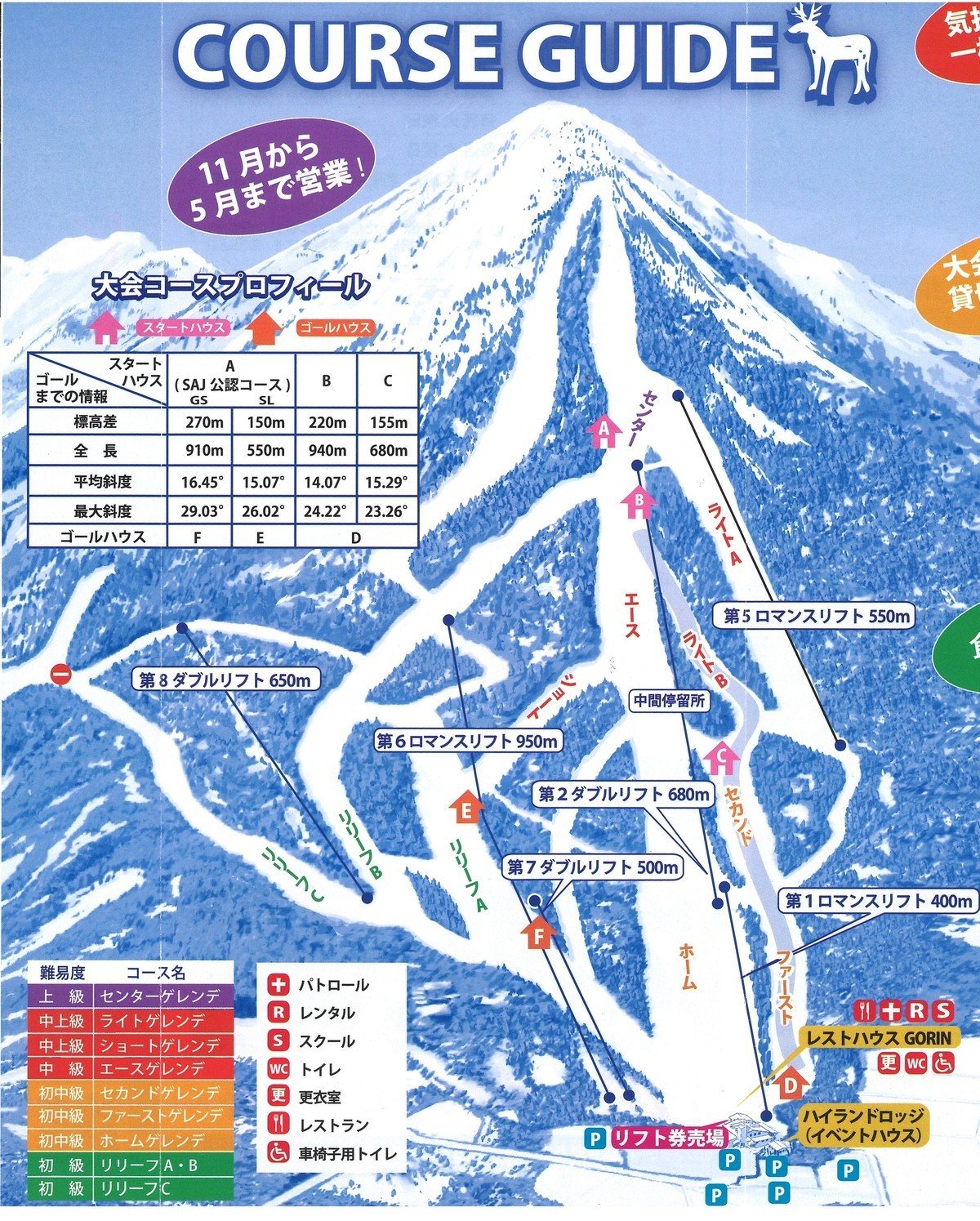 點圖看大圖Tap to enlarge
圖片來源:Snowline(snowline.jp)Image source: Snowline (snowline.jp) · 著作權屬各雪場,本站僅縮小轉載供參考。Copyright belongs to the resort; shown reduced for reference only.
3D 雪場地圖3D map
全螢幕 / 新分頁開啟Full screen / new tab拖曳旋轉、滾輪或雙指縮放。3D 地圖為非官方,地形來自 Mapterhorn,底圖為 OpenFreeMap,可切換國土地理院空拍圖,雪道與纜車來自 OpenStreetMap,收錄在「中部 3D 雪場地圖版本庫」(3DChubu-0010)。手機上有定位按鈕。Drag to rotate, scroll or pinch to zoom. Unofficial 3D map: terrain from Mapterhorn, OpenFreeMap basemap with a GSI aerial photo toggle, runs and lifts from OpenStreetMap, published in the Chubu 3D library (3DChubu-0010). On phones there is a locate button. chubu-3d.pages.dev
出典:国土地理院(加工)・© OpenStreetMap contributors(ODbL)Source: Geospatial Information Authority of Japan (processed) · © OpenStreetMap contributors (ODbL)