神立高原滑雪場Kandatsu Kogen

雪場資訊Resort info

神立以長緩坡、公園、技術地形與滑後浴場的組合形成鮮明日遊風格,官方雪道也有更陡進階選擇及夜滑路線。少量顧客評價稱讚新雪與整潔更衣、洗手設施,支持其實用配套優勢;但重雪、深坑與初級區人潮亦被提及。適合想把滑行與休憩完整安排的人,不能把漂亮山腳設施等同全山容易,夜間營運日期仍須另核。Kandatsu combines long gentler pistes, parks, technical terrain and a bath-and-sauna option after skiing. Official course information also identifies much steeper challenges and routes used for evening skiing. A few customers praise fresh snow and clean changing and toilet facilities, supporting its practical day-trip appeal. Other accounts describe heavy snow, ruts and busy beginner slopes. It suits skiers who value both activity and recovery, with the caution that an appealing base does not make every slope easy or every night an operating night.
- 縣/地區Prefecture / area
- 新潟縣 · 湯澤町Yuzawa · Niigata
- 標高/落差Elevation / vertical
- 山腳 460 m・山頂 1,000 m・垂直 540 mBase 460 m · top 1,000 m · vertical 540 m來源source
- 纜車Lifts
- 5 座5來源source
- 最長滑道Longest run
- 3.5 km來源source
- 2026-27 開放日2026-27 opening
- 2026-12-11(12/11–12/18 為預備季,12/19 起進入旺季)2026-12-11 (pre-season 11–18 Dec; top season from 19 Dec)來源source
- 地形公園Terrain park
- 有:場內設有多處雪地公園。Yes: Various snow parks.來源source
- 票價Lift prices
大人Adult シニアSenior 兒童Child 1 日券(平日1日券(大人))1-day (平日1日券(大人)) ¥5,800 — — 2026-27 大人 1 日券,日圓。JAPANSNOWLINE 於 10/24 對照官網確認;長者與兒童票價未整理,請以官網為準。2026-27 adult 1-day ticket in yen, checked against the official site by JAPANSNOWLINE on 10/24. Senior and child prices not yet compiled; check the official site.
來源source
雪道圖Trail map
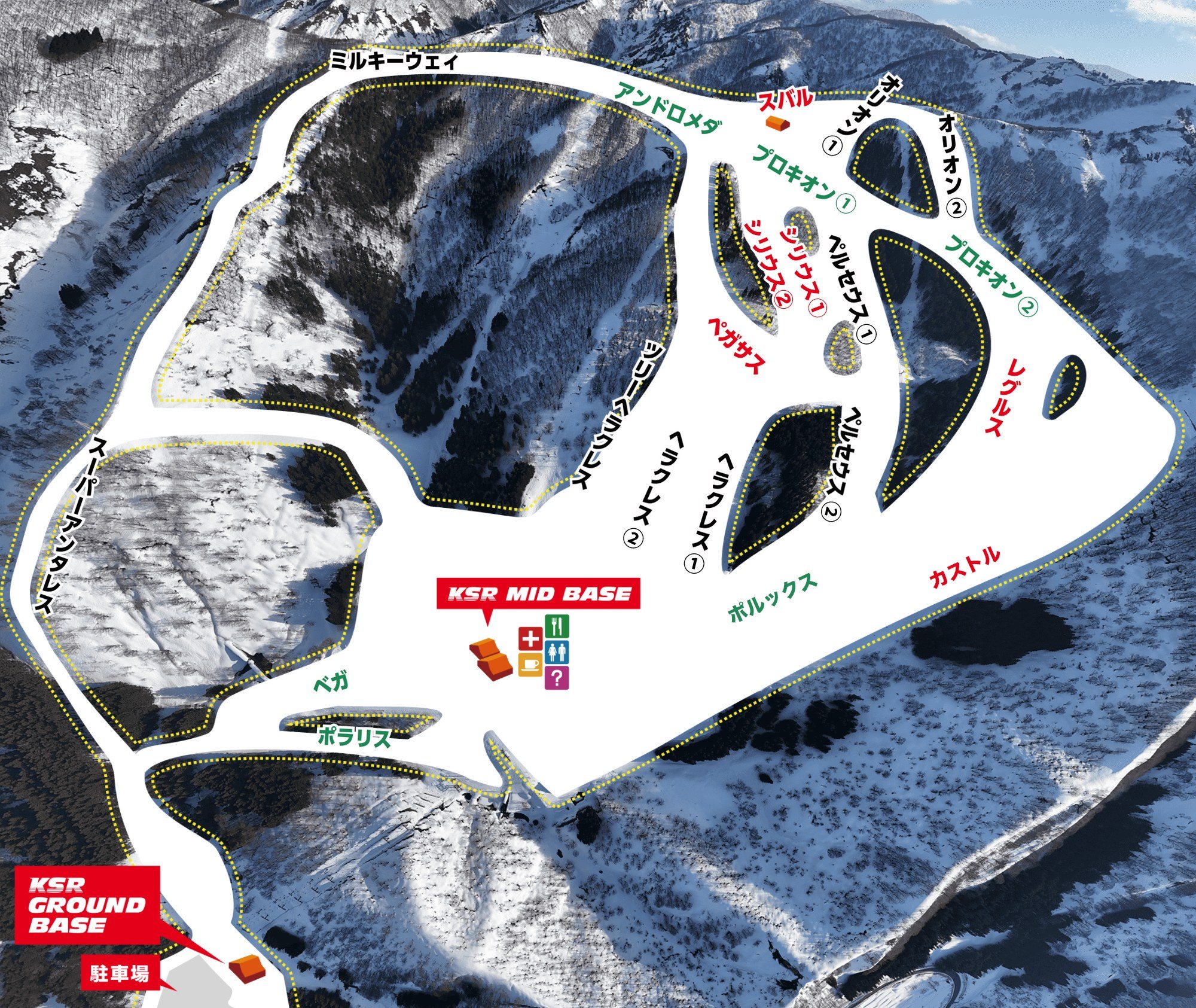 點圖看大圖Tap to enlarge
官網「コースガイド」的ゲレンデ案內圖(官網的空拍底圖與コース名稱圖層合成,沒有纜車標示)。Gelände map from the official “Course guide” page (the official aerial base image and the course-name layer composited; lifts are not marked).
圖片來源:雪場官方Image source: official ski field · 著作權屬各雪場,本站僅縮小轉載供參考。Copyright belongs to the resort; shown reduced for reference only.
3D 雪場地圖3D map
全螢幕 / 新分頁開啟Full screen / new tab拖曳旋轉、滾輪或雙指縮放。3D 地圖為非官方,地形來自 Mapterhorn,底圖為 OpenFreeMap,可切換國土地理院空拍圖,雪道與纜車來自 OpenStreetMap,收錄在「中部 3D 雪場地圖版本庫」(3DChubu-0010)。手機上有定位按鈕。Drag to rotate, scroll or pinch to zoom. Unofficial 3D map: terrain from Mapterhorn, OpenFreeMap basemap with a GSI aerial photo toggle, runs and lifts from OpenStreetMap, published in the Chubu 3D library (3DChubu-0010). On phones there is a locate button. chubu-3d.pages.dev
出典:国土地理院(加工)・© OpenStreetMap contributors(ODbL)Source: Geospatial Information Authority of Japan (processed) · © OpenStreetMap contributors (ODbL)