Hakuba47Hakuba47

雪場資訊Resort info

Hakuba47 將長線壓雪、饅頭坡與公園文化放在緊湊而可連接五龍的版圖中,官方雪道清楚列出不同程度路線,樹林滑區另有會員規則。少量顧客評價喜歡上下山雪質與路線趣味,但春季紀錄亦提醒下山線可能很快缺雪。適合重視技術與地形玩法的人;初級林道有狹窄轉折,樹林體驗也不能因見到別人滑行,就忽略登記及開放限制。Hakuba47 combines long groomers, moguls and a strong park identity within a mountain linked to Goryu. Official descriptions distinguish ability levels and require membership arrangements for designated tree-riding zones. A few customers enjoy the course quality and similar fresh-snow conditions at different heights, while spring logs warn that the lower descent can deteriorate quickly. It suits skiers seeking technique and terrain variety, with the qualification that beginner detours can be narrow and tree access remains subject to registration and opening rules.
- 縣/地區Prefecture / area
- 長野縣 · 白馬村Hakuba · Nagano
- 標高/落差Elevation / vertical
- 山腳 820 m・山頂 1,614 m・垂直 794 mBase 820 m · top 1,614 m · vertical 794 m來源source
- 纜車Lifts
- 5 座5來源source
- 最長滑道Longest run
- 6.4 km來源source
- 2026-27 開放日2026-27 opening
- 11 月下旬開放(預定)Late November (planned)來源source
- 地形公園Terrain park
- 有:47PARKS 地形公園,位於纜車山頂附近的 4 號路線;另有需登記的樹林區。Yes: 47PARKS by Route 4 from the gondola top; plus registered tree-riding zones.來源source
- 票價Lift prices
大人Adult 長者Senior 兒童Child 1 日券1-day ¥10,000 — ¥4,500 2026-27 雪季 1 日券,日圓,取自 SnowJapan(整理自官網)。原文分級:Adult (ages 23-64): 10,000 yen;Child (ages 6-12): 4,500 yen。未列出的票種請以官網為準。2026-27 1-day ticket in yen, from SnowJapan (compiled from the official site). Categories as listed: Adult (ages 23-64): 10,000 yen; Child (ages 6-12): 4,500 yen.
來源source
雪道圖Trail map
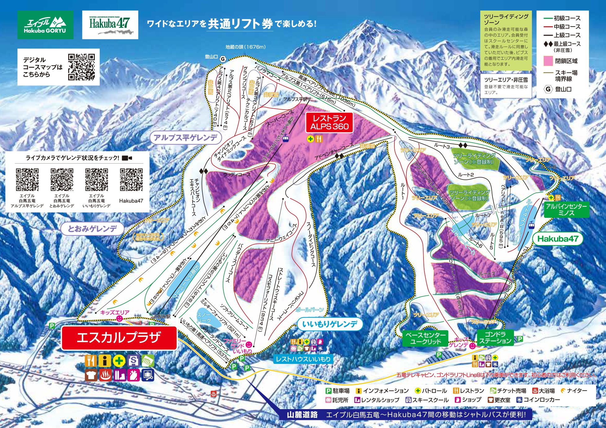 點圖看大圖Tap to enlarge
白馬五龍與 Hakuba47 共用同一張雪道圖。Hakuba Goryu and Hakuba47 share this one trail map.
圖片來源:Snowline(snowline.jp)Image source: Snowline (snowline.jp) · 著作權屬各雪場,本站僅縮小轉載供參考。Copyright belongs to the resort; shown reduced for reference only.
3D 雪場地圖3D map
全螢幕 / 新分頁開啟Full screen / new tab拖曳旋轉、滾輪或雙指縮放。3D 地圖為非官方,地形來自 Mapterhorn,底圖為 OpenFreeMap,可切換國土地理院空拍圖,雪道與纜車來自 OpenStreetMap,收錄在「中部 3D 雪場地圖版本庫」(3DChubu-0010)。手機上有定位按鈕。Drag to rotate, scroll or pinch to zoom. Unofficial 3D map: terrain from Mapterhorn, OpenFreeMap basemap with a GSI aerial photo toggle, runs and lifts from OpenStreetMap, published in the Chubu 3D library (3DChubu-0010). On phones there is a locate button. chubu-3d.pages.dev
出典:国土地理院(加工)・© OpenStreetMap contributors(ODbL)Source: Geospatial Information Authority of Japan (processed) · © OpenStreetMap contributors (ODbL)