夏油高原Geto Kogen

雪場資訊Resort info

夏油高原的辨識度來自豪雪形象與分級樹林滑行區,官方明確要求相應技術,並建議由較低難度逐步探索。少量顧客肯定雪道趣味與良好雪況,也有人提醒新雪競爭激烈、很快被滑過。它適合有能力處理變化雪面、又希望探索森林地形的人;不能把豪雪名聲等同每日鬆雪,也不能把樹林分級理解為初學者無風險體驗。Geto Kogen's identity centres on heavy-snow skiing and a graded system of tree-run areas. Official guidance explicitly stresses the skills required and recommends progressing through the area's difficulty levels. A few visitors enjoy the course quality and good conditions, but another notes intense competition for fresh tracks. It is distinctive for capable skiers interested in wooded terrain, not a guarantee of untouched powder all day. Even the easier designated tree sectors require judgement and are not ordinary beginner slopes.
- 縣/地區Prefecture / area
- 岩手縣 · 北上市Kitakami · Iwate
- 標高/落差Elevation / vertical
- 山腳 640 m・山頂 1,070 m・垂直 430 mBase 640 m · top 1,070 m · vertical 430 m來源source
- 纜車Lifts
- 5 座5來源source
- 最長滑道Longest run
- 3 km來源source
- 2026-27 開放日2026-27 opening
- 2026-11-28(最早)2026-11-28 (earliest)來源source
- 地形公園Terrain park
- 有:G Park,初到高級皆宜Yes: G Park, all levels來源source
- 票價Lift prices
- 未整理Not compiled yet
雪道圖Trail map
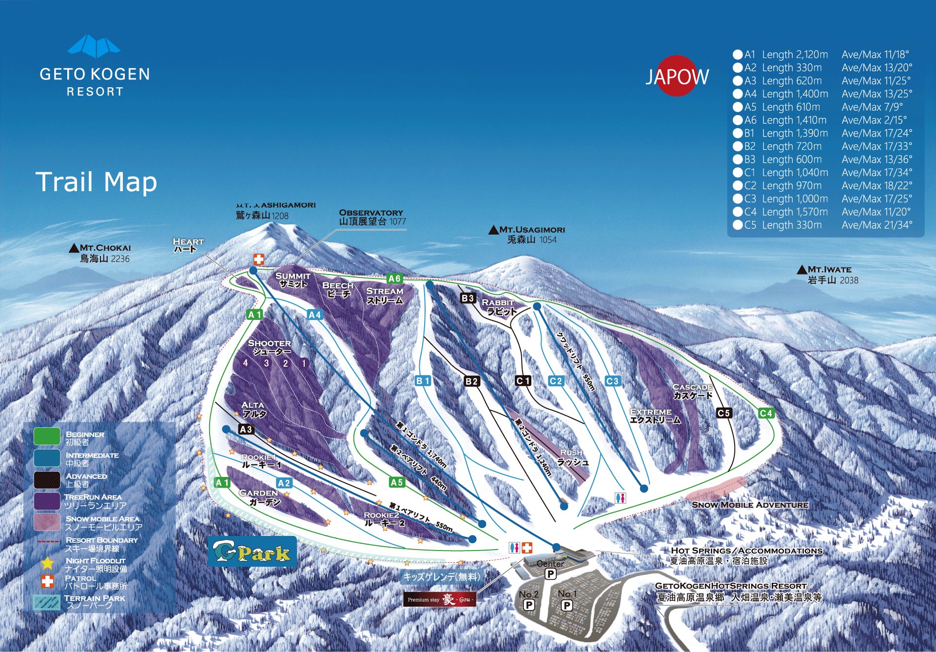 點圖看大圖Tap to enlarge
圖片來源:雪場官方Image source: official ski field · 著作權屬各雪場,本站僅縮小轉載供參考。Copyright belongs to the resort; shown reduced for reference only.
3D 雪場地圖3D map
全螢幕 / 新分頁開啟Full screen / new tab拖曳旋轉、滾輪或雙指縮放。3D 地圖為非官方,地形來自 Mapterhorn,底圖為 OpenFreeMap,可切換國土地理院空拍圖,雪道與纜車來自 OpenStreetMap,收錄在「東北 3D 雪場地圖版本庫」(3DMap-0015)。手機上有定位按鈕。Drag to rotate, scroll or pinch to zoom. Unofficial 3D map: terrain from Mapterhorn, OpenFreeMap basemap with a GSI aerial photo toggle, runs and lifts from OpenStreetMap, published in the Tohoku 3D library (3DMap-0015). On phones there is a locate button. tohoku-3d.pages.dev
出典:国土地理院(加工)・© OpenStreetMap contributors(ODbL)Source: Geospatial Information Authority of Japan (processed) · © OpenStreetMap contributors (ODbL)
附近溫泉Nearby onsen
夏油高原溫泉 兔森之湯Geto Kogen Usamori-no-yu
雪場內溫泉,滑完直接泡Onsen inside the ski resort
餐廳Food
藪屋 花卷總本店Yabuya Hanamaki
推薦Try 碗子蕎麥
花卷老字號碗子蕎麥Hanamaki's classic wanko soba