GALA 湯澤滑雪場GALA Yuzawa

雪場資訊Resort info

GALA 湯澤的鮮明優勢是鐵路日遊便利與山上租借、學校、餐飲等集中配套,官方雪道亦由緩坡延伸至非壓雪挑戰。少量顧客分享從都市出發的省事感,並肯定整理雪面及山景;但中央區觀光人潮與候車較多,北區當日可能較從容。適合無車或時間有限的滑雪日,不應把交通便利等同滑行零等待,初級林道亦有狹窄轉彎。GALA Yuzawa's clearest advantage is a rail-friendly day trip supported by concentrated rentals, lessons and dining. Official courses extend beyond gentle practice to more demanding ungroomed options. A few customers appreciate the easy journey from the city, prepared surfaces and scenery. Another finds the central area busy with sightseeing traffic while the northern sector has less waiting on that visit. It suits car-free or time-limited skiing, but convenient transport does not guarantee immediate lifts, and some easy forest routes include narrow turns.
- 縣/地區Prefecture / area
- 新潟縣 · 湯澤町Yuzawa · Niigata
- 標高/落差Elevation / vertical
- 山腳 358 m・山頂 1,181 m・垂直 823 mBase 358 m · top 1,181 m · vertical 823 m來源source
- 纜車Lifts
- 12 座12來源source
- 最長滑道Longest run
- 2.5 km來源source
- 2026-27 開放日2026-27 opening
- 2026-12-19(12/12–12/18 僅 Gondola 與觀光纜車營業;南區本季休業)2026-12-19 (12–18 Dec: gondola and sightseeing lift only; South area closed this season)來源source
- 地形公園Terrain park
- 未整理Not compiled yet
- 票價Lift prices
大人Adult シニアSenior 兒童Child 1 日券(ゴンドラ&リフト1日券(大人、窓口))1-day (ゴンドラ&リフト1日券(大人、窓口)) ¥8,000 — — 2026-27 大人 1 日券,日圓。JAPANSNOWLINE 於 10/24 對照官網確認;長者與兒童票價未整理,請以官網為準。2026-27 adult 1-day ticket in yen, checked against the official site by JAPANSNOWLINE on 10/24. Senior and child prices not yet compiled; check the official site.
來源source
雪道圖Trail map
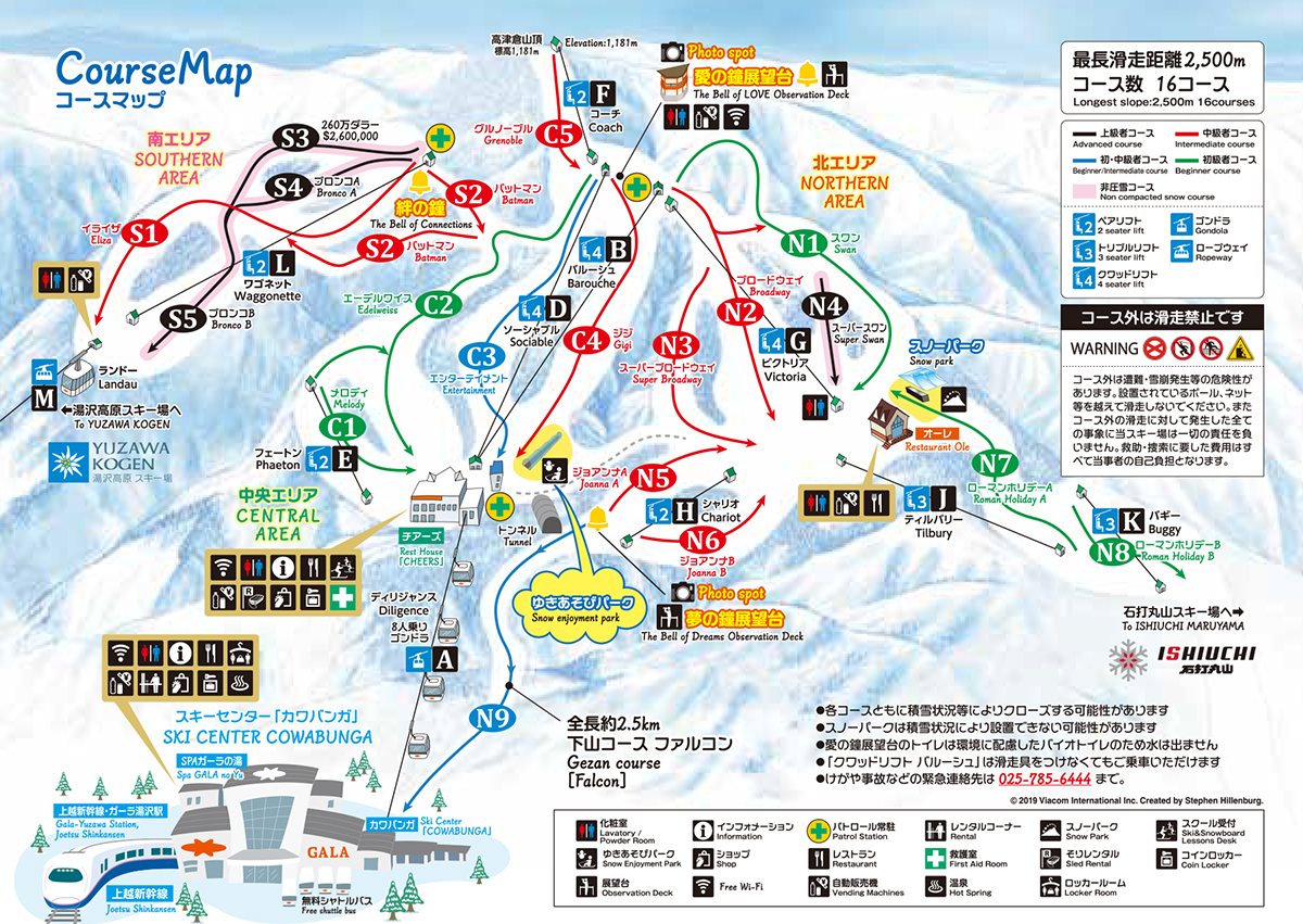 點圖看大圖Tap to enlarge
圖片來源:Snowline(snowline.jp)Image source: Snowline (snowline.jp) · 著作權屬各雪場,本站僅縮小轉載供參考。Copyright belongs to the resort; shown reduced for reference only.
3D 雪場地圖3D map
全螢幕 / 新分頁開啟Full screen / new tab拖曳旋轉、滾輪或雙指縮放。3D 地圖為非官方,地形來自 Mapterhorn,底圖為 OpenFreeMap,可切換國土地理院空拍圖,雪道與纜車來自 OpenStreetMap,收錄在「中部 3D 雪場地圖版本庫」(3DChubu-0010)。手機上有定位按鈕。Drag to rotate, scroll or pinch to zoom. Unofficial 3D map: terrain from Mapterhorn, OpenFreeMap basemap with a GSI aerial photo toggle, runs and lifts from OpenStreetMap, published in the Chubu 3D library (3DChubu-0010). On phones there is a locate button. chubu-3d.pages.dev
出典:国土地理院(加工)・© OpenStreetMap contributors(ODbL)Source: Geospatial Information Authority of Japan (processed) · © OpenStreetMap contributors (ODbL)