CanmoreCanmore Ski Village

雪場資訊Resort info

Canmore 位於東川,以接近旭川機場、地形變化與方便安排短程滑雪為特色。官方提供不同程度雪道、租借及夜滑服務;少量顧客分享喜歡流暢的壓雪坡,亦有家庭肯定鄰近住宿與地方食品。它較適合作為道北旅程中的練習站,而非以巨大落差吸引人。週末滑雪學校可能使雪道繁忙,部分陡坡亦須視積雪開放。Canmore's strengths are practical access from Asahikawa Airport and an interesting mix of slopes in Higashikawa. The official resort offers rentals, terrain for different abilities and evening skiing. A small selection of visitors praises enjoyable carving surfaces, while a family account values nearby accommodation and local food. It works well as a manageable stop on a northern Hokkaido itinerary, rather than a mountain chosen for enormous vertical. Weekend lessons and snow-dependent opening of steeper terrain deserve attention.
- 縣/地區Prefecture / area
- 北海道 · 上川郡東川町Hokkaido
- 標高/落差Elevation / vertical
- 山腳 210 m・山頂 456 m・垂直 246 mBase 210 m · top 456 m · vertical 246 m來源source
- 纜車Lifts
- 2 座2來源source
- 最長滑道Longest run
- 1.6 km來源source
- 2026-27 開放日2026-27 opening
- 2026 年 12 月中旬至 2027 年 3 月中旬(待確認,具體開幕日未公布)Mid-December 2026 to mid-March 2027 (to be confirmed; exact opening date not announced)來源source
- 地形公園Terrain park
- 未整理Not compiled yet
- 營業時間Hours
- 9:00–20:30(夜間 16:30–20:30)9:00–20:30 (night 16:30–20:30)來源source
- 夜間滑雪Night skiing
- 有:16:30–20:30Yes: 16:30–20:30來源source
- 定休日Closing days
- 未整理Not compiled yet
- 票價Lift prices
- 未整理Not compiled yet
雪道圖Trail map
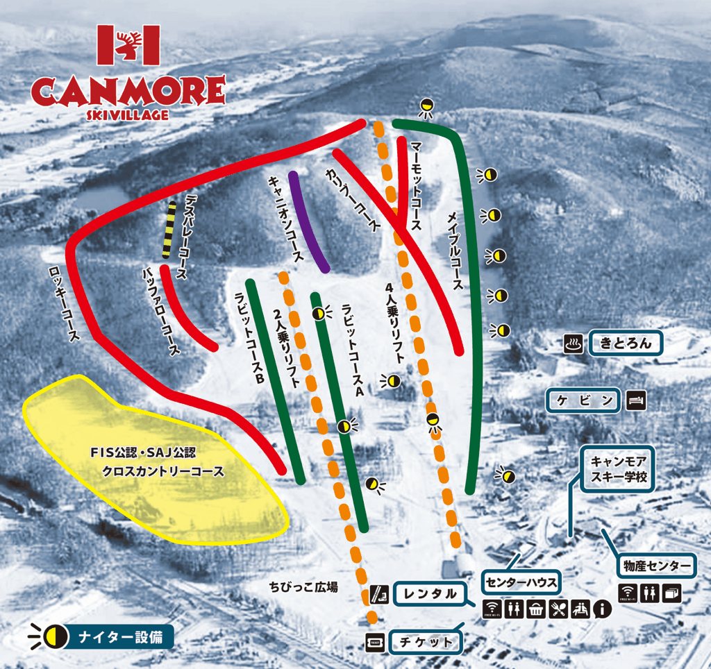 點圖看大圖Tap to enlarge
官網未提供可下載雪道圖;採 Snowline 雪道圖(2026-01-27)。No downloadable official map; Snowline course map (2026-01-27).
圖片來源:Snowline(snowline.jp)Image source: Snowline (snowline.jp) · 著作權屬各雪場,本站僅縮小轉載供參考。Copyright belongs to the resort; shown reduced for reference only.
3D 雪場地圖3D map
全螢幕 / 新分頁開啟Full screen / new tab拖曳旋轉、滾輪或雙指縮放。3D 地圖為非官方,地形來自 Mapterhorn,底圖為 OpenFreeMap,可切換國土地理院空拍圖,雪道與纜車來自 OpenStreetMap,收錄在「北海道 3D 雪場地圖版本庫」(3DHokkaido-0007)。手機上有定位按鈕。Drag to rotate, scroll or pinch to zoom. Unofficial 3D map: terrain from Mapterhorn, OpenFreeMap basemap with a GSI aerial photo toggle, runs and lifts from OpenStreetMap, published in the Hokkaido 3D library (3DHokkaido-0007). On phones there is a locate button. hokkaido-3d.pages.dev
出典:国土地理院(加工)・© OpenStreetMap contributors(ODbL)Source: Geospatial Information Authority of Japan (processed) · © OpenStreetMap contributors (ODbL)