旭岳Asahidake Ropeway

雪場資訊Resort info

旭岳的核心是空中纜車通往大雪山的自然雪世界,而非設施密集、全程壓雪的休閒雪場。官方冬季資訊須與一般登山纜車資訊分開理解;少量滑行紀錄欣賞新雪與山岳體驗,也反映強風、視線不良及春季黏雪。這裡較適合有相應技術、裝備與風險判斷能力者;道外滑行不等同受巡邏保護的普通雪道,初訪宜尋求專業指導。Asahidake is defined by ropeway access to a natural mountain environment, rather than a dense network of groomed resort pistes. Official winter guidance needs to be read alongside the operator's general sightseeing information. The small visitor sample conveys the excitement of fresh snow and mountain skiing, but also records strong wind, poor visibility and sticky spring conditions. It is best approached with appropriate skills, equipment and judgement; skiing beyond managed courses is not equivalent to ordinary patrolled resort skiing.
- 縣/地區Prefecture / area
- 北海道 · 東川町Higashikawa · Hokkaido
- 標高/落差Elevation / vertical
- 山腳 1,100 m・山頂 1,600 m・垂直 500 mBase 1,100 m · top 1,600 m · vertical 500 m來源source
- 纜車Lifts
- 1 座1來源source
- 最長滑道Longest run
- 未整理Not compiled yet來源source
- 2026-27 開放日2026-27 opening
- 纜車 2026-12-11 起營運(11/16–12/10 維修停駛);滑雪路線視積雪開放Ropeway runs from 2026-12-11 (closed 16 Nov – 10 Dec for maintenance); ski routes open when snow allows來源source
- 地形公園Terrain park
- 未整理Not compiled yet
- 纜車Ropeway
- 山麓站約 1,100 m → 姿見站約 1,600 m,約 10 分;旭岳山頂 2,291 mBase station about 1,100 m → Sugatami station about 1,600 m, about 10 min; summit 2,291 m來源source
- 營運時間Hours
- 12 月 9:00–15:40(最後下行);1 月以後官方尚未公布December 9:00–15:40 (last descent); January onward not yet published by the resort來源source
- 滑雪路線Ski routes
- A~D 共 4 條,積雪夠才開放(高山地形,沒有整備的雪道)4 routes A–D, open only with enough snow (alpine terrain, no groomed runs)來源source
- 票價Lift prices
大人Adult シニアSenior 子供Child 纜車來回(冬季)Ropeway round trip (winter) ¥2,800 — ¥1,750 冬季纜車來回價,日圓。這裡沒有另外的雪場纜車券,滑雪者買的就是纜車票。Winter ropeway round-trip price in yen. There is no separate lift pass; skiers buy the ropeway ticket.
來源source
雪道圖Trail map
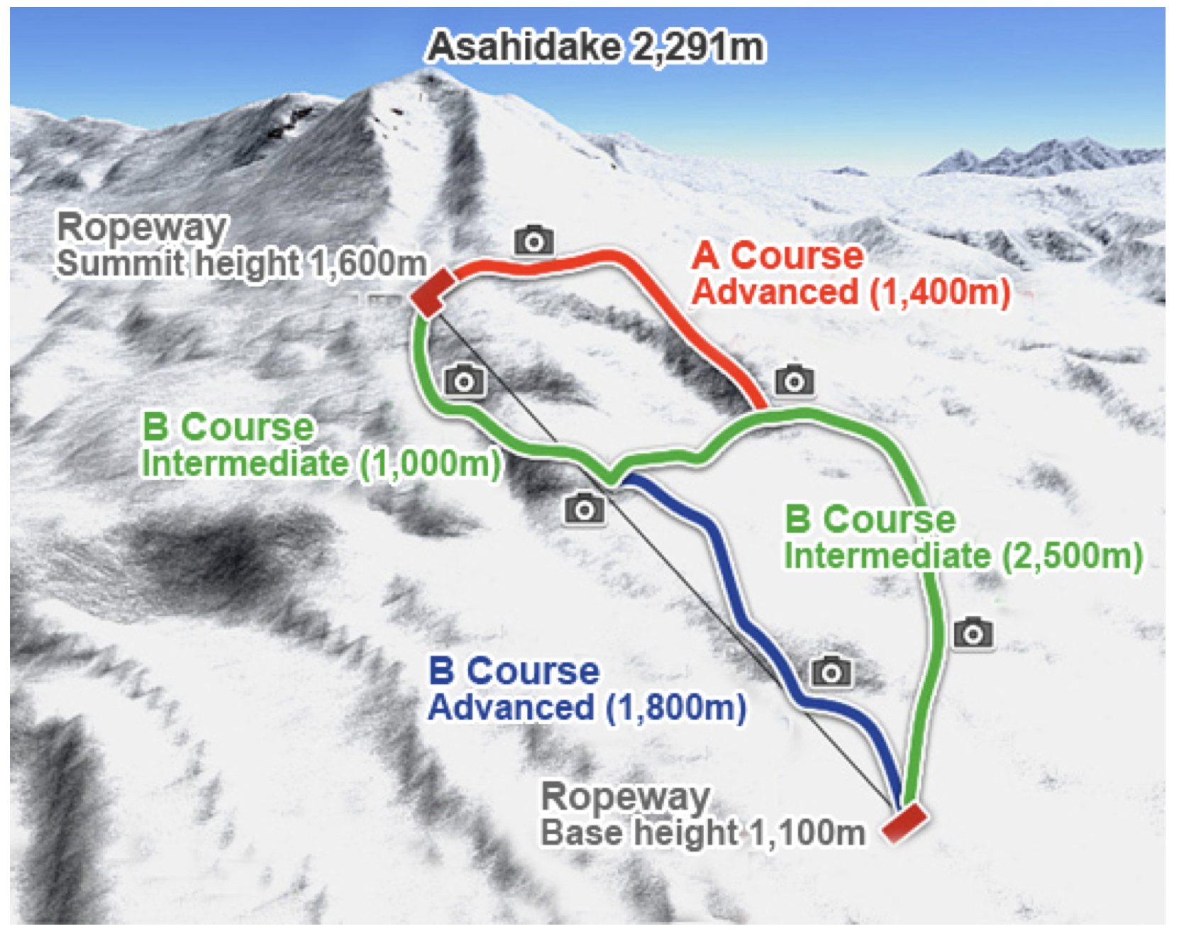 點圖看大圖Tap to enlarge
旭岳滑雪路線圖。山麓站 1,100 m、姿見站 1,600 m 的標高取自這張圖。Asahidake ski course map. The base (1,100 m) and Sugatami (1,600 m) elevations are taken from this map.
圖片由 Jeff 提供(應為旭岳纜車的官方路線圖,官方原圖網址未確認)Image supplied by Jeff (appears to be the Asahidake Ropeway course guide; official URL not confirmed) · 著作權屬各雪場,本站僅縮小轉載供參考。Copyright belongs to the resort; shown reduced for reference only.
3D 雪場地圖3D map
全螢幕 / 新分頁開啟Full screen / new tab拖曳旋轉、滾輪或雙指縮放。3D 地圖為非官方,地形來自 Mapterhorn,底圖為 OpenFreeMap,可切換國土地理院空拍圖,雪道與纜車來自 OpenStreetMap,收錄在「北海道 3D 雪場地圖版本庫」(3DHokkaido-0007)。手機上有定位按鈕。Drag to rotate, scroll or pinch to zoom. Unofficial 3D map: terrain from Mapterhorn, OpenFreeMap basemap with a GSI aerial photo toggle, runs and lifts from OpenStreetMap, published in the Hokkaido 3D library (3DHokkaido-0007). On phones there is a locate button. hokkaido-3d.pages.dev
出典:国土地理院(加工)・© OpenStreetMap contributors(ODbL)Source: Geospatial Information Authority of Japan (processed) · © OpenStreetMap contributors (ODbL)
交通Access
- 開車By car
- 旭川站約 1 小時 10 分;旭川機場約 60 分About 1 h 10 min from Asahikawa Station; about 60 min from Asahikawa Airport
附近溫泉Nearby onsen
旭岳溫泉Asahidake Onsen
纜車山麓站就在旭岳溫泉。官網只列溫泉區名,未列個別設施。The ropeway base is in Asahidake Onsen. The official site names the area only, no individual baths.
白金溫泉Shirogane Onsen
車程約 1 小時 10 分(官網)。只列溫泉區名。About 1 h 10 min by car (official site). Area name only.
層雲峽溫泉Sounkyo Onsen
約 2 小時 30 分(官網)。只列溫泉區名。About 2 h 30 min (official site). Area name only.
餐廳Food
山麓站食堂Base station restaurant
咖哩、拉麵(官網未列店名)。2026/11/16–12/10 維修停業。Curry and ramen (no name on the official site). Closed for maintenance 16 Nov – 10 Dec 2026.
山頂(姿見)站輕食區Sugatami station snack corner
可樂餅、咖啡(官網未列店名)。2026/11/16–12/10 維修停業。Croquettes and coffee (no name on the official site). Closed for maintenance 16 Nov – 10 Dec 2026.