安比高原APPI Kogen

雪場資訊Resort info

安比高原以長距離、多路線的滑行與完整酒店配套見長,官方介紹其大範圍雪道與山麓度假設施,適合希望連住、持續練習的旅客。有限顧客評價肯定整理後雪面及春季仍可享受的滑行,亦有人提醒纜車受影響時可用地形大幅縮減。其特色是規模與連續滑行潛力,而非每次都有粉雪;選擇日期與查看運輸狀態同樣重要。APPI Kogen offers long-run skiing on a substantial mountain with a full hotel-based resort infrastructure. Official information emphasises its extensive course network, making it attractive for a stay built around repeated days on snow. A small customer sample praises well-prepared surfaces and enjoyable spring sessions, but another report highlights how severely lift interruptions can reduce available skiing. Its distinguishing strength is sustained terrain variety supported by accommodation, not a guarantee of powder or full-mountain access on every visit.
- 縣/地區Prefecture / area
- 岩手縣Iwate
- 標高/落差Elevation / vertical
- 山腳 620 m・山頂 1,328 m・垂直 708 mBase 620 m · top 1,328 m · vertical 708 m來源source
- 纜車Lifts
- 6 座6來源source
- 最長滑道Longest run
- 5.5 km來源source
- 2026-27 開放日2026-27 opening
- 2026-12-052026-12-05來源source
- 地形公園Terrain park
- 有:APPI SNOW PARK:bank、wave、跳臺、箱子、鐵桿Yes: APPI SNOW PARK: banks, waves, jumps, boxes, rails來源source
- 票價Lift prices
- 未整理Not compiled yet
雪道圖Trail map
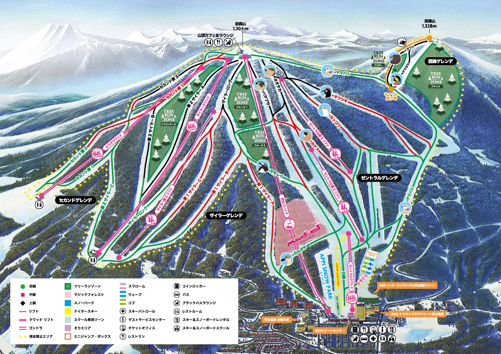 點圖看大圖Tap to enlarge
圖片來源:雪場官方Image source: official ski field · 著作權屬各雪場,本站僅縮小轉載供參考。Copyright belongs to the resort; shown reduced for reference only.
3D 雪場地圖3D map
全螢幕 / 新分頁開啟Full screen / new tab拖曳旋轉、滾輪或雙指縮放。3D 地圖為非官方,地形來自 Mapterhorn,底圖為 OpenFreeMap,可切換國土地理院空拍圖,雪道與纜車來自 OpenStreetMap,收錄在「東北 3D 雪場地圖版本庫」(3DMap-0015)。手機上有定位按鈕。Drag to rotate, scroll or pinch to zoom. Unofficial 3D map: terrain from Mapterhorn, OpenFreeMap basemap with a GSI aerial photo toggle, runs and lifts from OpenStreetMap, published in the Tohoku 3D library (3DMap-0015). On phones there is a locate button. tohoku-3d.pages.dev
出典:国土地理院(加工)・© OpenStreetMap contributors(ODbL)Source: Geospatial Information Authority of Japan (processed) · © OpenStreetMap contributors (ODbL)