赤倉觀光Akakura Kanko Resort

雪場資訊Resort info

赤倉觀光以纜車進入的長線巡航、山腰酒店景觀與較具運動感的雪道見長,官方亦明列壓雪與非壓雪路線。少量近期顧客評價認為中緩坡適合連續滑行,新雪日也有樂趣;餐飲則有具體好評。相同來源亦記下濃霧與濕雪,提醒其山景及滑行感受仰賴天氣。與赤倉溫泉相鄰不代表票券或所有連接隨時通用,仍須先查。Akakura Kanko combines gondola-accessed cruising, a distinctive mountainside hotel setting and a more sporting course selection. Official information clearly separates prepared and ungroomed routes. A few recent customers enjoy sustained skiing on moderate gradients, with fresh snow adding another dimension; individual reviews also praise food. Fog and wet snow appear in the same evidence, so scenery and flow remain weather-dependent. Being adjacent to Akakura Onsen does not establish identical ticket coverage or unrestricted connecting access; those arrangements need checking separately.
- 縣/地區Prefecture / area
- 新潟縣 · 妙高市Niigata
- 標高/落差Elevation / vertical
- 山腳 740 m・山頂 1,500 m・垂直 760 mBase 740 m · top 1,500 m · vertical 760 m來源source
- 纜車Lifts
- 6 座6來源source
- 最長滑道Longest run
- 4.5 km來源source
- 2026-27 開放日2026-27 opening
- 2026-12-19 至 2027-05-05(SnowJapan)2026-12-19 to 2027-05-05 (SnowJapan)來源source
- 地形公園Terrain park
- 有:Akakan Snow Park(Main Park、Second Park),在赤倉觀光飯店附近Yes: Akakan Snow Park (Main Park and Second Park) near the Akakura Kanko Hotel來源source
- 營業時間Hours
- 全季每天 8:30–16:008:30–16:00 daily all season來源source
- 夜間滑雪Night skiing
- 無None來源source
- 定休日Closing days
- 無定休日(雪季每天營業;SnowJapan)No regular closing days (open every day of the season; SnowJapan)
- 票價Lift prices
大人Adult 長者Senior 兒童Child 1 日券1 day ¥7,000 ¥6,000 ¥5,200 連續 2 日券2 days consecutive ¥12,300 ¥9,900 ¥8,700 SnowJapan 2026-27 季價格;年齡分級依雪場規定,部分雪場另有高中生等票種,請以官網為準。SnowJapan 2026-27 prices. Age bands follow each resort; some resorts have extra categories such as high-school tickets. Check the official site.
來源source
雪道圖Trail map
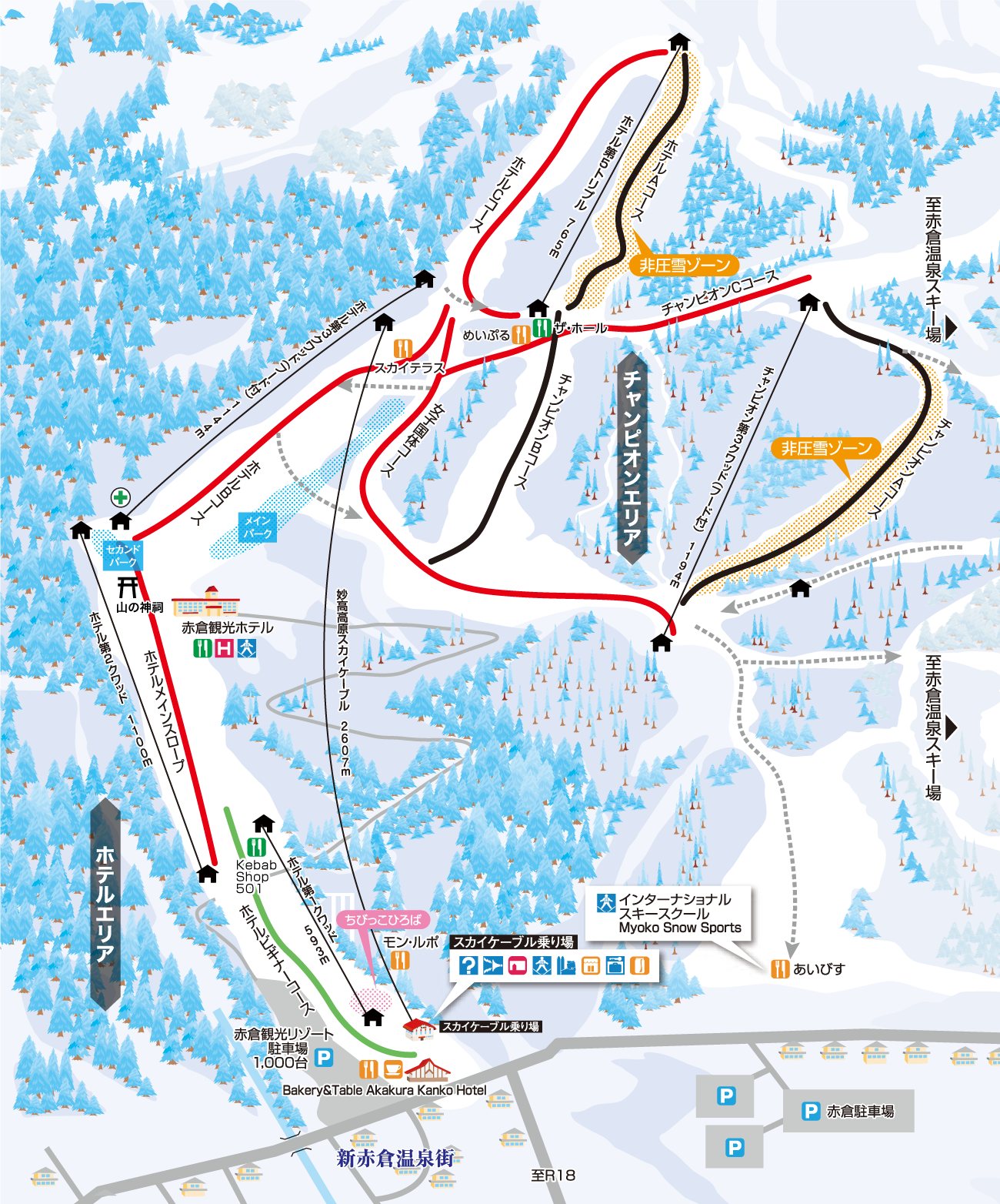 點圖看大圖Tap to enlarge
官網雪道圖。Official slope map.
圖片來源:雪場官方Image source: official ski field · 著作權屬各雪場,本站僅縮小轉載供參考。Copyright belongs to the resort; shown reduced for reference only.
3D 雪場地圖3D map
全螢幕 / 新分頁開啟Full screen / new tab拖曳旋轉、滾輪或雙指縮放。3D 地圖為非官方,地形來自 Mapterhorn,底圖為 OpenFreeMap,可切換國土地理院空拍圖,雪道與纜車來自 OpenStreetMap,收錄在「中部 3D 雪場地圖版本庫」(3DChubu-0010)。手機上有定位按鈕。Drag to rotate, scroll or pinch to zoom. Unofficial 3D map: terrain from Mapterhorn, OpenFreeMap basemap with a GSI aerial photo toggle, runs and lifts from OpenStreetMap, published in the Chubu 3D library (3DChubu-0010). On phones there is a locate button. chubu-3d.pages.dev
出典:国土地理院(加工)・© OpenStreetMap contributors(ODbL)Source: Geospatial Information Authority of Japan (processed) · © OpenStreetMap contributors (ODbL)